Arizona Water

In 1983, University of Arizona Tree Ring researchers warned:

Our results show that the projected climatic change would have serious overall effects on the west. The number of sub-regions that are expected to have water shortages by the year 2000 would essentially double. The regions drained by the Colorado River and the Rio Grande would be especially hard hit as there is presently little, if any, unallocated water in these basins. Allocation changes required to meet a diminishing water supply would be extremely difficult in these basins due to the complex web of international treaties, interstate compacts and both federal and local laws.[1]

Arizona water sources
D. Meeks
Oct. 10, 2020
Data source:
Arizona Department of Water Resources.
2020.
Arizona Water Facts
http://www.arizonawaterfacts.com/water-your-facts
CC BY-SA 4.0
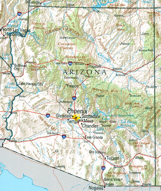
Over the last 40 years, Arizona's population has increased by about 4 million residents.[2] Arizona's water utilities and organizations have made great strides in water conservation since the 1983 report.

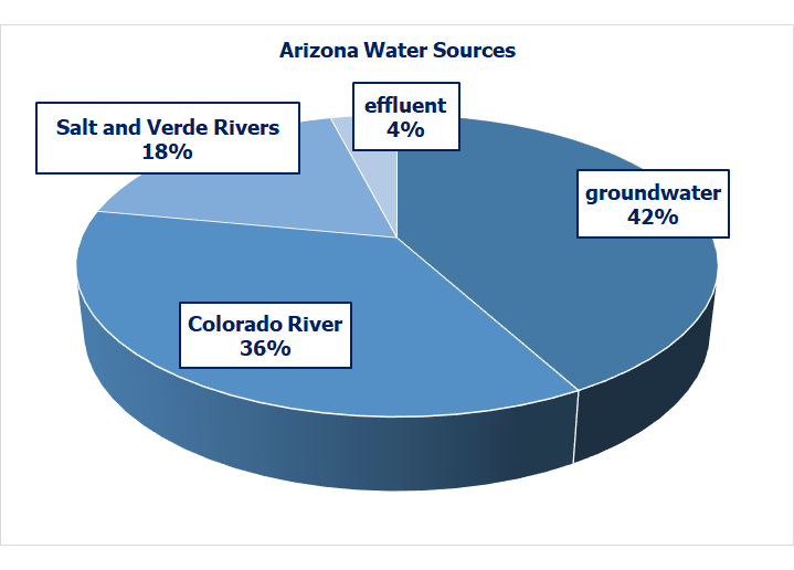
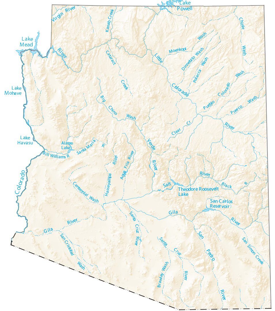
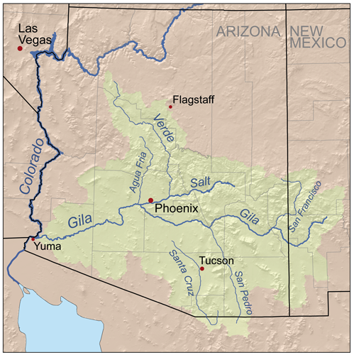
About 42% of Arizona's water use comes from groundwater, 36% from the Colorado River, 18% from in-state rivers, including the Salt and Verde and 4% from high-quality treated wastewater called effluent.[3]

Water resources have been managed primarily by the Salt River Project (SRP), the Central Arizona Project (CAP) and water utilities in the Phoenix and Tucson metropolitan areas. Their geographic domains, business structures and relationships with Arizona's Tribes have been shaped by more than 150 years of evolving federal and state laws and regulations.

Sources:

[1] Stockton, C. W. (Jul. 1983). Final report submitted to the National Science Foundation: Projected effects of climatic variation upon water availability in Western United States. Laboratory of Tree Ring Research. University of Arizona. https://repository.arizona.edu/bitstream/handle/10150/303523/ltrr-0048.pdf?sequence=1&isAllowed=y

[2] Country Economy. (n. d.). Arizona - population. https://countryeconomy.com/demography/population/usa-states/arizona

[3] Paul, H. (Oct. 2, 2018). 10 things you should know about Arizona's Groundwater Management Act. Audubon Society. https://www.audubon.org/news/10-things-you-should-know-about-arizonas-groundwater-management-act


Water Geology

Grand Canyon
Grand Canyon
D. Meeks
Aug. 2, 2014
Image taken by and used with
permission of the author
CC BY-SA 4.0
Many of Arizona's most beautiful sights have been created by water. The most famous is the Grand Canyon, a World Heritage Site of 1,218,375 acres on the Colorado Plateau. The canyon owes its existence to the erosive power of the Colorado River, which descends nearly 2,000 feet as it travels through 277 miles of the canyon.[1],[2]

The canyon's average depth is 4,000 feet deep. It is 6,000 feet deep at its deepest point and 18 miles at its widest.[1]

The canyon's uppermost layer is Kaibab limestone,hard sedimentary rock, composed mainly of calcium carbonate or dolomite, used as building material and in the making of cement which was formed at the bottom of the ocean. It now sits at the top of the Colorado Plateau, more than 9,000 feet above sea level.[2]

Plate tectonicsa theory that explains the movement of Earth's lithospheric plates over its mantle lifted the Colorado Plateau between 70 and 30 million years ago. The river exposed spectacular layers of sedimentary rock, deposited by water. The oldest canyon rocks have been dated at 1.8 billion years.[2]

The two current hypotheses explaining the uplift are shallow-angle subductionoccurs at convergent tectonic plate boundaries where a denser plate moves under a less dense plate or uplift caused by isostasy.state of gravitational equilibrium between Earth's crust and mantle, the crust floats at an elevation that depends on its thickness and density[2]

Antelope Canyon, east of Page, is a small slot canyon,a long, narrow canyon channel with vertical sedimentary rock walls that formed after thousands of years of desert weather extremes. Its red color is due to the iron oxides that mixed with the sand that formed the canyon walls 191 to 174 million years ago.[3]

Lower Antelope Canyon
Moondigger
Apr. 16, 2005
Wikipedia Antelope Canyon
https://en.wikipedia.org/
wiki/Antelope_Canyon#/media/
File:Lower_antelope_3_md.jpg
public domain
Water from flash floods and the creek that flows through the canyon seeped into bedrock fissures, wearing away Navajo sandstone.[3]

The canyon is divided into two sections. Located at an elevation of 4,000 feet, Upper Antelope Canyon is the most famous, and is also known as "The Crack." The Navajo name for Upper Antelope Canyon, which is about 100 yards long and 120 feet deep, is Tsé bighánílíní, which means "the place where water runs through rocks." The canyon floor is usually dry and flat, but wet during monsoon season.[3]

Lower Antelope Canyon is about 4.5 miles northwest of Upper Antelope Canyon. It is a little more than a mile in length, and narrower than the Upper Canyon along the canyon floor. The Navajo name for Lower Antelope Canyon is Hasdestwazi, meaning "spiral rock arches." It is also called "The Corkscrew."[3]

Upper and Lower Antelope Canyon are a part of a system of several streams that flow into Lake Powell.[3]

The 84,000 acres of Canyon de Chelly National Monument in the northeastern corner of the state, is located on the Navajo Nation in Chinle. About 40 families live within the park boundary which is managed by the National Park Service and the Navajo Nation.[4]

Like the Grand Canyon, Canyon de Chelly was formed by running water. The Tsaile and Whiskey Creeks joined to form the Chinle Wash, which carved through de Chelly sandstone deposited during the Permian Period, 230 to 205 million years ago. In some places, the canyon is 800 feet deep.[5]

Canyon de Chelly, seven riders and a dog
E. S. Curtis
Jan. 1, 1904
Wikipedia Canyon de Chelly
https://en.wikipedia.org/
wiki/Canyon_de_Chelly_National
_Monument#/media/File:
Canyon_de_Chelly,_Navajo.jpg
public domain
Most sandstone forms horizontally. de Chelly sandstone is unusual because it contains cross-bedded,in layers lying at an angle to the main beds of layered rock depositional, sloping surfaces formed by sand dunes.[4]

The canyon provided protection to ancient Puebloans, who inhabited the canyon until the 1300s. The Hopi later migrated to the area, which was later settled by the Navajo.[5]

Tonto Natural Bridge, about 10 miles north of Payson, is considered the largest natural travertinea white, tan, cream, rust-colored fibrous or concentric limestone mineral deposited by mineral hot springs bridge in the world. It is 183 feet high over a 400-foot long tunnel that is 150 feet across at its widest point.[6]

Pine Creek, where the bridge is located, was formed by a rhyolitean extrusive igneous rock with a very high silica content, usually pink or gray in color with grains so small that they are difficult to observe without a hand lens, made up of quartz, plagioclase, and sanidine, with minor amounts of hornblende and biotite lava. The rock eroded, leaving purple quartz sandstone, which was lithified,transform from sediment into stone tilted, faulted and eroded.[6]

The area was covered by seawater, leaving sand and mud comprised of limestone sediments. More volcanic eruptions covered the sediment with lava, forming a basalta dark, fine-grained volcanic rock that sometimes displays a columnar structure, typically composed largely of plagioclase with pyroxene and olivine cap which eroded and was shifted, creating the canyon.[6]

About 5,000 years ago, precipitation began seeping underground through rock fractures, creating limestone aquifers and springs which carried dissolved limestone and calcium carbonatea white insoluble solid occurring naturally as chalk, limestone, marble and calcite, forming mollusk shells and stony corals creating a travertinea white, tan, cream or rust-colored fibrous or concentric limestone mineral deposited by mineral hot springs dam. The dam was eroded from below creating the bridge.[6]

Kartchner Caverns is another spectacular geologic wonder. Located in southern Arizona, the cave was discovered in 1974 by Gary Tenen and Randy Tufts, who were exploring the limestone hills at the eastern base of the Whetstone Mountains. Unprotected caves can be seriously damaged, so Tenen and Tufts thought about developing the cave themselves. They kept the cave secret until February 1978 when they told property owners James and Lois Kartchner about their discovery.[6]

Tonto Natural Bridge
D. Meeks
Aug. 2, 2014
Image taken by and used with
permission of the author
CC BY-SA 4.0
Members of the Kartchner family were impressed with the development and operation of Catalina State Park by Arizona State Parks, and approached Arizona State Parks to determine if there was interest in acquiring the cave.[7]

Arizona State Parks finally purchased Kartchner on September 16, 1988, after 10 years of research, planning, construction, and legal issues which cost more than $28 million. The Conservation Celebration of Kartchner Caverns State Park was held on November 5, 1999. The lower caverns opened to the public on November 11, 2003.[7]

The cave's formation began with a shallow inland sea that covered the area 330 million years ago. The sea deposited sediment layers and fossils that hardened into Escabrosa limestone. Over the last 10 to 15 million years, the limestone uplifted, forming the Whetstone Mountains.[8]

A block of the limestone dropped down a fault thousands of feet below the mountains. Acidic rainwater penetrated the limestone block, creating the cave rooms and passages. Over thousands of years, dripping water formed speleothems.a mineral deposit formed in a cave[8]

Sources:

[1] National Park Service. (n. d.). Grand Canyon. https://www.nps.gov/grca/learn/nature/index.htm

[2] National Park Service. (n. d.). Grand Canyon geology. https://www.nps.gov/grca/learn/nature/grca-geology.htm

[3] Buscher, D. & Buscher, L. (Jan. 6, 2020). Antelope Canyon photos: Where water runs through rocks. LiveScience. https://www.livescience.com/antelope-canyon-photos.html

[4] National Park Service. (May 3, 2019). Canyon de Chelly National Monument. https://www.nps.gov/cach/learn/historyculture/index.htm

[5] DesertUSA.com (2020). Canyon de Chelly. https://www.desertusa.com/ind1/du_cdcdesc.html

[6] Arizona State Parks. (2020). Tonto Natural Bridge State Park. https://azstateparks.com/tonto/explore/science

Kartchner Caverns
Arizona State Parks
Dec. 5, 2009
YouTube
https://www.youtube.com/watch?v=uF75q4vzbAY
Embedded video, no copy made
[7] Arizona State Parks. (2020). Kartchner Caverns State Park history. https://azstateparks.com/kartchner/explore/park-history

[8] Arizona State Parks. (2020). Kartchner Caverns State Park science. https://azstateparks.com/kartchner/explore/science


Water History

Agriculture in the Salt River Valley began over 2,000 years ago with the Hohokam, who lived in the valley until about 1450. They constructed a sophisticated canal system that watered tens of thousands of acres of valley farmland.[1]

Settlers arrived in the Salt River Valley during the 1860s when a U.S. Army outpost was established in 1865 at Camp McDowell, near the intersection of the Salt and Verde Rivers. Soldiers built canals from the Verde River and planted crops.[1]

In 1867 settlers from Wickenburg led by Jack Swilling came to the valley and dug a ditch adjacent to a prehistoric Hohokam canal. One end of that ditch is now buried beneath north runway of Phoenix Sky Harbor International Airport.[1]

The city of Phoenix, named in honor of the departed Hohokam community, was formed in 1870, when those living along Swilling's Ditch formed the Salt River Town Association, establishing their new town along a half-square-mile area between what is now Seventh Street and Seventh Avenue, south of Van Buren Street. They called the new town Phoenix. Swilling's Ditch was later named the Salt River Valley Canal.[1]

1884 Joint Head Dam ruins where Swilling built his ditch
Marine 69-71
Mar. 5, 2017
Wikipedia Jack Swilling
https://en.wikipedia.org/
wiki/Jack_Swilling#/media/
File:Phoenix-Joint_Head_Dam-1884-6.jpg
CC BY-ND 4.0
Settlers used Hohokam canals, diverting water from distant Salt and Verde river snowmelt for irrigation. The Tempe Canal Company began more extensive canal construction in 1871, with a dam and headgates miles upstream from Hayden Butte. Company founders each paid $200 for tools and provisions. Nine other men joined the effort, and the canal was completed by the mid-1880s. Additional canal companies were formed, later becoming large real estate enterprises. When completed, the canal was forty miles long, and its dam and headgate moved to Granite Reef.[1]

Over the next decade, several canal companies combined, but water rights became contentious. The Arizona territory applied the "doctrine of appropriation," which recognized "beneficial use." Anyone could divert water from a river or stream with a few provisions:

In 1863, Judge William Howell drafted the 400-page legal code for the entire Arizona Territory. The Howell Code included water rights provisions, establishing the state's surface water as public property. His system ensured that during a drought, some farm land was guaranteed to get sufficient water to maintain food crops. Control was no longer strictly in the hands of canal companies.[1]

A seven-year drought, which began in 1891, was the result of low snowfall in northern valleys that supplied water to the Salt and Verde Rivers.[1]

Wormser v. Salt River Valley Canal, et al. (1892) became a landmark in Arizona water rights law. Judge Joseph Kibbey held that water rights belonged with the land, and could not be transferred, sold, or rented for use at other locations.[1]

Water used in growth and production of a loaf of bread?
Farmers were concerned that new settlers would remove too much forest timber, which served as a snow-retention area during the winter. In 1897 the Arizona Territorial Legislature asked Congress to reserve unclaimed timber land in the Salt River Valley watershed.

On August 17, 1898 President William McKinley signed Proclamation No. 19, creating the Apache-Sitgreaves National Forest in the northeastern Arizona Territory. It was followed by the Tonto National Forest, created on October 3, 1905.[1]

Apache-Sitgreaves National Forest
Nightryder84
Oct. 29, 2008
Wikipedia Apache-Sitgreaves National Forest
https://en.wikipedia.org/
wiki/Apache%E2%80%93Sitgreaves_
National_Forests#/media/
File:Apache_Abbas.JPG
CC BY-SA 3.0
Land investors realized that most water rights had already been claimed and that new developments would be water-limited, especially during times of drought. Several companies attempted new irrigation problems, but ran out of funding.[1]

The 1894 Carey Act granted millions of acres to the states and territories to finance irrigation so that local governments and private partnerships would construct storage dams and create irrigation districts,a special political taxing district established for agricultural improvement or irrigation and conservation purposes but the act failed to launch substantial irrigation projects because the states, territories and investors could not meet financial obligations.[1]

By the depression of the mid-1890s investors were apprehensive about funding water projects and political conversations resulted in the 1902 National Reclamation Act, providing government funding for reclamation projects. Users would reimburse the federal government once they took over the completed projects.[1]

The Salt River Valley Water Users Association (SRVWUA), formed in 1903 by commercial and local farmers, small ranchers and businesses and wealthy businessmen, filed its articles with the Maricopa County recorder on February 7, 1903 and two days later with the Secretary of the Arizona Territory.

SRVWUA enabled residents to use their land as collateral for the federal funds to construct Roosevelt Dam. Because the association represented a broad constituency it united water users in the Phoenix area and reduced litigation and competition for water resources. Area landowners could join SRVWUA for a fee of ten cents per acre.[1]

In 1904 SRVWUA initiated Patrick T. Hurley v. Charles F. Abbott, et al., 259 F. Supp. 669 (D. Ariz. 1966), to clarify water rights. The federal government joined the suit as a cross-complainant on behalf of the Indians of the Salt River and Fort McDowell Reservations.[1]

Wetlands adjacent to rivers and streams are?
The Salt River Project was one of the first federal reclamation projects. By September 1905 a road through the Superstion Mountains, later named the Apache Trail, had been built to move men and resources to the site of the future Roosevelt Dam. Because dam construction required significant power, water was diverted from the Salt River via a 19-mile canal.[1]

By 1908 2,000 people were living in the town of Roosevelt.[1]

Fort McDowell Ruins
Fort McDowell Ruins
Marine 69-71
Jan. 15, 2007
Wikipedia Ft. McDowell, Arizona
https://en.wikipedia.org/
wiki/Fort_McDowell,_Arizona#/media/
File:Fort_McDowell_Yavapai_
Nation-Fort_McDowell_Ruins-1.jpg
CC BY-ND 4.0
U.S. Reclamation Service engineers and SRVWUA leaders believed that the Salt River Project (SRP) should control the irrigation system and the Granite Reef dam, which diverted water into the Arizona canal, creating Martin Lake.[1]

In March 1910, Judge Edward Kent issued his Hurley opinion, which defined the three classes of valley water:

Kent also determined water allocations to the Salt River and Fort McDowell Reservations and gave them the highest priority.[1]

The Roosevelt Dam was dedicated in 1911. By 1915 Roosevelt Lake had filled with snow runoff even though 1,000 acre-feet of water per day was being released for irrigation. In 1917 the federal government transferred operation of the Salt River Project (SRP) to SRVWUA, which sent the first reimbursement payment of $132,000 to the federal government in December.[1]

Sources:

[1] Salt River Project. (2017). The story of SRP: Water, power, and community. https://www.srpnet.com/assets/srpnet/pdf/about/history/Story-of-SRP-History-Book.pdf


Colorado River Basin[*]

Colorado River Basin
Shannon1
Jan. 25, 2018
Wikipedia Colorado River
https://en.wikipedia.org/
wiki/Colorado_River#/media/
File:Colorado_River_basin_map.png
CC BY-SA 4.0
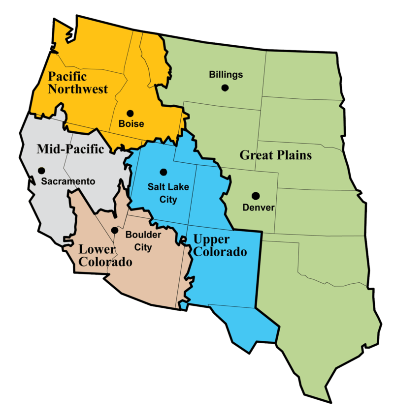
Colorado River water management is governed by a complex system of international treaties, interstate compacts and Supreme Court decrees which began in 1922 with the Colorado River Compact.[8]

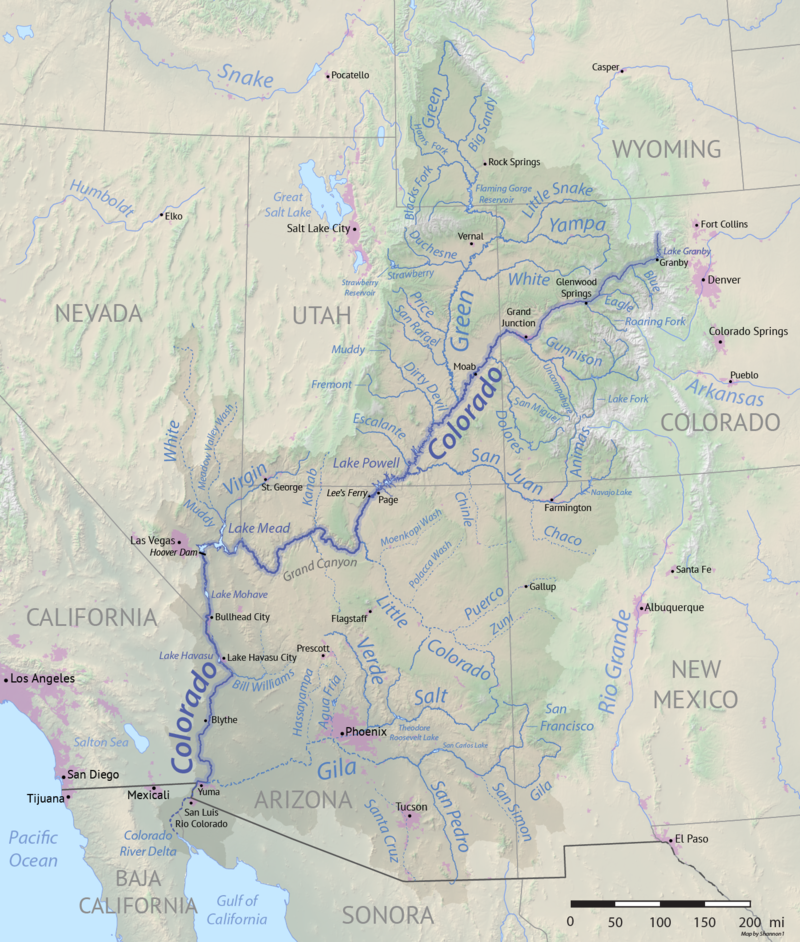
The Colorado River is about 1,450 miles long. 
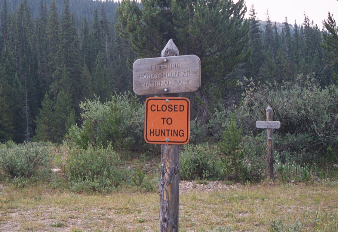
The headwaters of the Colorado River are located in Rocky Mountain National Park near Grand Lake, Colorado.[17] It is about 1,450 miles long and flows across the international border into Mexico. The drainage basin area is about 246,000 square miles and includes all of Arizona and parts of California, Colorado, New Mexico, Nevada, Utah and Wyoming.[1]

The river system supports $1.4 trillion of the annual U.S. economy and 16 million jobs, about 1/12 of U.S. domestic product. Without Colorado River water Arizona's gross state product would drop by more than $185 billion per year and the state would lose more than 2 million jobs.[16]

For every 1 Co temperature rise Colorado River flow has decreased by 9.3%, a depletion of 1.5 billion tons of water lost to evaporation or lack of melting snowpack.[16]

In addition to temperature changes dust may also control the speed at which spring snowmelt feeds the headwaters of the Colorado River. More dust correlated with faster spring runoff and higher peak flows because dust-covered snow is darker and absorbs more heat than white snow.[18]

Windblown dust has increased in the Southwest due to climate change and human land-use. As rainfall decreases protective soil is removed exposing bare soil. Winter and spring winds pick up the dusty soil and drop it on the Rockies to the northeast at an annual rate of about five times higher than in the mid-1800s.[18]

The major tributaries of the Colorado River, from northeast to southwest, include the Green, Dirty Devil, Escalante and San Juan Rivers. The Green River also has several major tributaries (from northeast to southwest) including the Uinta, White, Willow Creek, Price and San Rafael Rivers.[2]

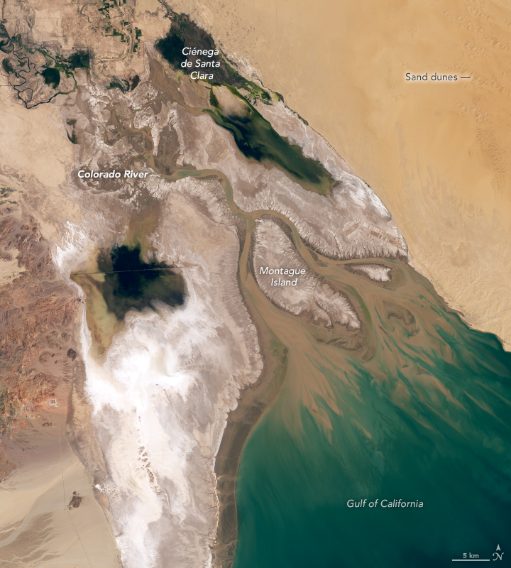
The Colorado River used to flow into a marsh in the Gulf of California.Gulf of California
Gulf of California
NASA
Nov. 30, 2003
Wikipedia Gulf of California
https://en.wikipedia.org/
wiki/Gulf_of_California#/media/
File:Gulf_of_California.jpg
public domain
Now it disappears in the farmlands at the base of the Sierra de Juarez Mountains Sierra de Juarez Mountains
Sierra Juarez
Prsjl
Aug. 2, 2009
Wikipedia Sierra Juárez, Oaxaca
https://en.wikipedia.org/
wiki/Sierra_Ju%C3%A1rez,_Oaxaca#/
media/File:Yagila.JPG
CC BY-SA 3.0
in Mexico, until nothing remains. Only about 10 percent of all the water that flows into the Colorado River reaches Mexico, where it is used for farming.[3]

Modern use of Colorado River water began in the late 1800s when water was diverted to California's Imperial Valley The Imperial Valley from the highway between Tijuana and Mexicali
The Imperial Valley from the highway between Tijuana and Mexicali
CharismaticDespot
Jun. 12. 2019
Wikipedia Imperial Valley
https://en.wikipedia.org/
wiki/Imperial_Valley,_California#/
media/File:ImperialValleyfromBC.jpg
CC BY-SA 4.0
for irrigation. Competition for Colorado River water has resulted in decades of political and legal confrontation and compromise.[4]

The Colorado River is an important water resource for areas outside of the basin, including Denver, Salt Lake City, Albuquerque, Los Angeles and San Diego for municipal water, and the Imperial Valley in California for agricultural water. The river and its tributaries provide water to the nearly 30 million people, both within and outside of the basin and it irrigates nearly 4 million acres of agricultural lands.[1]

In the early 1900s, Arizona, California, Colorado, Nevada, New Mexico, Utah and Wyoming negotiated for shares of the Colorado River.

Current annual allotments in the Lower Basin were established in 1928 as part of the Boulder Canyon Project.[6]

Arizona, Nevada and California comprise the Lower Basin and receive 2.8 million acre-feet, 300,000 acre-feet and 4.4 million acre-feet respectively. The 1944 U.S.-Mexico Water Treaty provides 1.5 million acre-feet of Colorado River water to be delivered to Mexico annually.[5]

Current specific annual allotments in the Upper Basin were established by the Upper Colorado River Basin Compact of 1948.[7]

The very bad math drying up the Colorado River
Grist
Apr. 26, 2023
YouTube
https://www.youtube.com/watch?v=AzpYHXgfbbI
Embedded video, no copy made
Colorado River Allocations
basin state percent million acre ft/year m3/s
Upper Basin 7.50 293.0
Colorado 51.75* 3.86 150.7
Utah 23.00* 1.71 67.0
Wyoming 14.00* 1.04 40.8
New Mexico 11.25* 0.84 32.8
Arizona 0.70 0.05 2.0
*A percentage of the total after Arizona's 0.05 million acre-feet per year are deducted.
Arizona's percentage is of the total.
Lower Basin 7.50 293.0
California 58.70 4.40 172.0
Arizona 37.30 2.80 109.0
Nevada 4.00 0.30 12.0
Aerial view of Hoover Dam
M. Ortiz
Sep. 23, 2017
Wikipedia Hoover Dam
https://en.wikipedia.org/
wiki/Hoover_Dam#/media/File:
2017_Aerial_view_Hoover_Dam_4774.jpg
CC BY-SA 4.0
Arizona has the right to use of up to 2.8 million acre-feet of Colorado River water annually, making the river Arizona's largest renewable water supply. Half is provided to Colorado River water users, and the other half to Central Arizona Project water users.[4]

Arizona's Colorado River water has a unique priority rights system:

The Bureau of Reclamation plays a major role in the control and distribution of surface water within the Colorado River Basin through management of large federal water projects like Glen Canyon Dam and Lake Powell and Hoover Dam and Lake Mead.[1]

More than 10% of the river's water is lost, due to reservoir evaporation and seepage. Upper Basin states are already charged for evaporation from federally-managed reservoirs, but Lower Bsin states are not, based on the Supreme Court Arizona v. California decision.[12]

Glen Canyon Dam substation and bridge near Page
Glen Canyon Dam,
substation and bridge near Page
Adbar
Mar. 1, 2010
Wikipedia Glen Canyon Dam
https://en.wikipedia.org/
wiki/Glen_Canyon_Dam#/media/
File:Glen_Canyon_Dam_and_Bridge.JPG
CC BY-SA 3.0
If the federal government changes this practice, Lower Basin states could see their allotments cut even more. Total evaporation and water loss in the Lower Basin usually exceeds 1 million acre-feet, about the amount of water used by Utah each year from the Colorado.[12]

The new Lower Colorado River Basin System Conservation and Efficiency Program, funded by an initial allocation through the Inflation Reduction Act and managed through the Bureau of Reclamation, will help increase water conservation, improve water efficiency, and prevent system reservoirs from falling to critically low elevations that would threaten water deliveries and power production.[13]

Hoover Dam is located in Black Canyon on the Colorado River at the Arizona-Nevada border. It was constructed between 1930 and 1936 and is the highest concrete arch dam in the U.S. It created Lake Mead, which extends for 115 miles (185 km) upstream and is one of the largest artificial lakes in the world. The dam is used for flood and silt control, hydroelectric power for 1.3 million,[15] agricultural irrigation and domestic water supply.[9]

Glen Canyon Dam is the second highest concrete-arch dam in the U.S. and created the 26.2 million acre-feet of water storage capacity in Lake Powell. The Glen Canyon power plant produces around 5 billion kilowatt-hours of hydroelectric power annually, distributed by the Western Area Power Administration to Wyoming, Utah, Colorado, New Mexico, Arizona, Nevada and Nebraska. Hydropower revenues help fund environmental programs associated with Glen and Grand canyons.[10]

Between January 2000 and April 2023 water storage in Lakes Mead and Powell decreased by 33.5 million acre feet (41.3 billion cubic meters). As of April 2023 water storage was sufficient for only 15 months.[21] A team of UCLA scientists estimated that between 2000 and 2021 rising temperatures led to evaporation of 32.5 million acre-feet of water in the Colorado River Basin, more than the entire storage capacity of Lake Mead.[22]

Based on 2023 Lake Powell and Lake Mead depths another four or five years of high Colorado River flow rates would be required to refill both reservoirs. Colorado River water researchers said this is unlikely, given that the river now transports an average of 20% less water each year than it did during the 20th century.[20]

To the delight of many hikers, Lake Powell's low water level recently revealed long-hidden Cathedral in the Desert and the Gregory Natural Bridge. These formations were flooded when Glen Canyon Dam was completed.[14]

Colorado River delta
L. Dauphin/USGS/NASA
Apr. 25, 2020
https://en.wikipedia.org/wiki/Colorado_River_Delta#/
media/File:Coloradoriverdelta_oli_APR2020.jpg
public domain
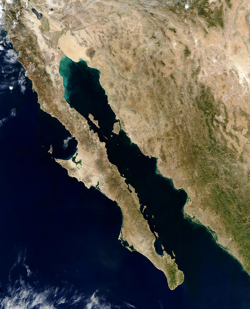
For decades, the merits of building the dam and water sustainability versus the apparent destruction of geologic wonders and changes to the canyon's flora and fauna have been debated by water managers and environmentalists.[14]

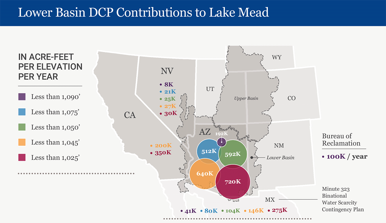
On May 22, 2023 Arizona, California and Nevada agreed to take less water from the Colorado. In return the federal government will pay $1.2 billion to irrigation districts, cities and Tribes related to the cutbacks. The agreement will end in 2026. The reductions are about 13% of Lower Colorado Basin water use, about 3 million acre-feet of water over the next three-an-a-half years.[19]

Based on the Jan. 1, 2024 projected level of Lake Mead at 1065.27 feet above sea level, the U.S. Secretary of the Interior has declared a Tier 1 shortage for Colorado River operations in 2024.[23]

On May 24, 2023, Tucson mayor Regina Romero signed a groundbreaking water conservation agreement with the Bureau of Reclamation and CAP. Under the agreement Tucson will be one of the first Arizona cities to leave a significant allocation of Colorado River water in Lake Mead and voluntarily conserve up to 110,000 acre-feet of water over three years.[24]

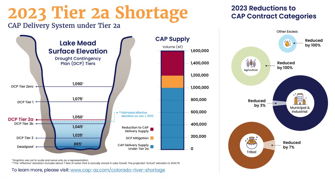
In 2023 Arizona conserved about 950,000 acre-feet, including the required 592,000 Tier 2a reduction and an additional voluntary contribution of 355,000 acre-feet to support the Colorado River system.[25]

One acre-foot equates to a yearly supply for three Arizona families.[5]

Sources:

[1] USGS. (n. d.). Colorado River Basin focus area study. https://www.usgs.gov/mission-areas/water-resources/science/colorado-river-basin-focus-area-study?qt-science_center_objects=0#qt-science_center_objects

[2] Geology.com. (n. d.). Utah lakes, rivers and water resources. https://geology.com/lakes-rivers-water/utah.shtml

[3] USGS. (n. d.). Rivers, streams and creeks. https://www.usgs.gov/special-topic/water-science-school/science/rivers-streams-and-creeks?qt-science_center_objects=0#qt-science_center_objects

[4] Arizona Department of Water Resources. (n. d.). Colorado River management. https://new.azwater.gov/crm/colorado-river-allocation

[5] Central Arizona Project. (n. d.). Background and history. https://www.cap-az.com/about/history-of-cap/

[6] National Archives. (1928). Boulder Canyon Project Act, 1928. https://www.archives.gov/milestone-documents/boulder-canyon-project-act

[7] U.S. Congress. (1948). Upper Colorado River Basin Compact, 1948. https://www.usbr.gov/lc/region/pao/pdfiles/ucbsnact.pdf

Cathedral in the Desert
Glen Canyon Institute
2018
https://www.glencanyon.org/
cathedral-in-the-desert/
Used with written permission of
Glen Canyon Institute
[8] Gelt, J. (Aug. 1997). Sharing Colorado River Water: History, public policy and the Colorado River Compact. Water Resources Research Center. https://wrrc.arizona.edu/publications/arroyo-newsletter/sharing-colorado-river-water-history-public-policy-and-colorado-river

[9] Petruzzello, M. (n. d.). Hoover Dam. Encyclopedia Britannica. https://www.britannica.com/topic/Hoover-Dam

[10] Bureau of Reclamation. (n. d.). Glen Canyon Unit. Interior region 7 - Upper Colorado Basin. https://www.usbr.gov/uc/rm/crsp/gc/

[11] Arizona Department of Water Resources. (2022). Colorado River management. https://new.azwater.gov/crm/colorado-river-allocation

[12] Runyon, L. (Sep. 30, 2022). Federal officials set their sights on Lower Colorado River evaporation to speed up conservation. NPR for Northern Colorado. https://www.kunc.org/environment/2022-09-30/federal-officials-set-their-sights-on-lower-colorado-river-evaporation-to-speed-up-conservation

[13] U.S. Department of the Interior. (Oct. 12, 2022). Drought mitigation funding from Inflation Reduction Act. https://www.doi.gov/pressreleases/biden-harris-administration-announces-new-steps-drought-mitigation-funding-inflation#:~:text=The%20newly%20created%20Lower%20Colorado,for%20those%20who%20live%20in

Kawuneeche Valley, near the headwaters of the Colorado River in Rocky Mountain National Park
Kawuneeche Valley, near the headwaters of
the Colorado River in Rocky Mountain National Park
D. Kowalczyk
2001
Wikipedia Colorado River
https://en.wikipedia.org/
wiki/Colorado_River#/media/
File:Kawuneeche_Valley.jpg
CC BY-SA 3.0
[14] Davis, T. (Dec. 31, 2022). At Glen Canyon, receding waters reveal a cathedral - and shift in debate. Tucson.com. https://tucson.com/news/local/subscriber/at-glen-canyon-receding-waters-reveal-a-cathedral-and-shift-debate/article_84c0e6e2-6f51-11ed-b17f-5b146a543326.html

[15] White, R. (Feb. 14, 2023). Why was the Hoover Dam built? NewsWeek. https://www.newsweek.com/hoover-dam-built-world-most-visited-1781104

[16] Jacobo, J. (Apr. 19, 2023). Here's what will happen if Colorado River system doesn't recover from 'historic drought.' abcNews. https://abcnews.go.com/US/happen-colorado-river-system-recover-historic-drought/story?id=98475953&utm_source=trellis&utm_medium=email&utm_campaign=Clips%20for%20April%2020,%202023

[17] Utah Department of Natural Resources. (n. d.). Utah division of water resources. https://water.utah.gov/interstate-streams/colorado-river-story/

[18] Rasmussen, C. (Jan. 23, 2018). Dust on snow controls springtime river rise in West. NASA Global Climate Change. https://climate.nasa.gov/news/2674/dust-on-snow-controls-springtime-river-rise-in-west/

[19] Flavelle, C. (May 22, 2023). A breakthrough deal to keep the Colorado River from going dry, for now. The New York Times. https://www.nytimes.com/2023/05/22/climate/colorado-river-deal.html

[20] Davis, T. (May 15, 2023). Refilling the Colorado River lakes all but unthinkable, experts say. tucson.com. https://tucson.com/news/local/subscriber/refilling-of-colorado-river-lakes-all-but-unthinkable-experts-say/article_48aaaa0c-ee82-11ed-99e7-a321a3a69e3c.html#:~:text=Lakes%20Powell%20and%20Mead%2C%20the,21st%20century%2C%20federal%20forecasts%20show.

[21] Schmidt, J. C., et al. (Jun. 17, 2023). The Colorado River water crisis: Its origin and the future. WIREs Water. https://wires.onlinelibrary.wiley.com/doi/10.1002/wat2.1672#

[22] James, I. (Jul. 30, 2023). Colorado River losing vast amounts of water due to warming climate, study finds. Los Angeles Times. https://www.latimes.com/environment/story/2023-07-30/study-shows-how-warming-climate-is-sapping-the-colorado-river?utm_source=Poynter+Institute&utm_campaign=15bc2e49da-07312023+-+The+Poynter+Report&utm_medium=email&utm_term=0_26742a15dc-15bc2e49da-390904996

[23] Central Arizona Project. (n. d.). 2024 Colorado River operations: Tier 1 shortage. Know Your Water News. https://knowyourwaternews.com/2024-colorado-river-operations-tier-1-shortage/

[24] City of Tucson. (Aug. 4, 2023). Tucson signs historic water conservation agreement to help save Lake Mead. Signals. https://www.signalsaz.com/articles/tucson-signs-historic-water-conservation-agreement-to-help-save-lake-mead/#:~:text=On%20May%2024%2C%202023%2C%20Mayor,River%20water%20in%20Lake%20Mead.

[25] Central Arizona Project. (n. d.). Arizona: Contributing to the stability of the Colorado River system. https://knowyourwaternews.com/arizona-contributing-to-the-stability-of-the-colorado-river-system/

 
[*] Some of the Colorado River section materials posted in this site originally posted at the Explore Utah → Colorado River Basin → Colorado River section of Journalism 455/555 Environmental Journalism and John Wesley Powell, 1834-1902, http://denisemeeks.com/journalism/jour_555/powell/ by this author


Sonoran Desert

Sonoran Desert
Sonoran Desert
National Park Service
Lake Mead National Recreation Area
https://www.nps.gov/lake/learn/nature/deserts.htm
public domain
The Sonoran Desert has been shaped by water. It is a transition between the Sierra Madre and the Rocky Mountains, the Pacific and Gulf coasts and the coastal lowlands of Baja California and the mid-continent.[3]

The desert covers 100,000 square miles of California, Arizona, Sonora, Mexico and Baja California.[1] and is part of the Basin and Range province composed of long, low valleys bordered by parallel mountain ranges formed more than 40 million years ago by volcanic activity that also formed the Chiricahua, Superstition, Ajo, Kofa, Galiuro and Gila mountains.[2]

About 12 million years ago the Basin and Range area expanded and stretched. Around 8 million years ago the expansion stopped and stabilized, leaving about 5,000 feet (1,525 m) of gravel, sand and clay in valleys that resulted in our current desert aquifers. About 6 million years ago California's San Andreas fault separated Baja California from the main part of the Sonoran Desert.[2]

The desert's northeastern boundary is the mile-high escarpmentlong, steep slope, especially one at the edge of a plateau or separating areas of land at different heights called the Mogollon RimMogollon Rim from east of Pine, Arizona
Mogollon Rim from east of Pine, Arizona
K. Dooley
Oct. 10, 2009
Wikipedia Mogollon Rim
https://en.wikipedia.org/wiki/
Mogollon_Rim#/media/File:
Mogollon_Rim_east_of_Pine.jpg
CC BY 2.0
of the Colorado Plateau.[2] The desert's eastern edge in southeast Arizona is composed of high valleys and mountain ranges including the Pinaleno and Chricahua mountains. The southeast edge is at the Sierra Madre Occidental, 30 million year-old volcanic rocks in Mexico. In the west the desert is bordered by mountain ranges between 3,000 and 10,000 feet.[2]

The desert contains three basaltic volcanic fields that formed in the last 4 million years. The most famous, the Pinacate in Sonora, Mexico, has a 4,000 foot stratovolcanoa volcano built up of alternate layers of lava and ash surrounded by hudreds of cinder conesa cone formed around a volcanic vent by fragments of lava thrown out during eruptions.[2]

Southern Basin and Range province
National Park Service
Geology Resources Division
https://www.nps.gov/common/uploads/photogallery/
nri/park/geology/4957D554-1DD8-B71B-0BC1F3
D1EB13998C/4957D554-1DD8-B71B-0BC1F3D1EB13998C-large.jpg
public domain
The desert seldom experiences earthquakes. The last major earthquake, measured at 7.2 on the Richter scale and centered south of Douglas near Bavispe, Sonora, on the afternoon of May 3, 1887. It created large dust clouds, massive rock falls, geysers and cracked walls.[2]

The oldest stratified rocks have been dated to about 1,200 million years ago. They contain algae and small mushrooms that survived despite Precambrian tides.[2]

Paleozoic (570 to 240 mya) shales and limestones include trilobites,an extinct fossil arthropod recognized by its distinctive three-lobed and three-segmented form shark and fish teeth, crinoids,any of a large class of invertebrates that are echinoderms and usually have a cup-shaped body with five or more feathery arms coral, bryzoans,a non-moving aquatic invertebrate of the phylum Bryozoa which comprises of the moss animals conodonts,a fossil marine animal of the Cambrian to Triassic periods, having a long wormlike body, numerous small teeth and a pair of eyes, may be the earliest vertebrate clams, brachiopods,animal with a hard valve on its upper and lower surface oysters and cephalopods.an active predatory mollusk of the large class Cephalopoda such as an octopus or squid[2]

Mesozoic (150 to 90 mya) fossils include lizard tracks, turtles, horsetails and petrified wood, formed when the land rose and water drained. Late Cretaceous rocks in the Santa Rita mountains include sauropods,a very large plant-eating quadruped dinosaur with a long neck and tail, small head and massive limbs horned and duckbilled dinosaurs and ancient mammals.[2]

Cenozoic rocks include fossil ancestors of modern horses, titanotheresan extinct herbivorous hoofed mammal of the family Brontotheriidae of the Eocene and Oligocene epochs and oreodonts.an extinct, four-toed, ruminant, artiodactyl mammal of the Merycoidodontidae and Agriochoeridae families living in North America from the Eocene to the early Pliocene and resembling swine

Pleistocene fossils from the last two million years include camels, bison, modern horses, mastodons,any of various extinct mammals of the elephant family existing from the Miocene through the Pleistocene distinguished by molar teeth with cone-shaped cusps mammoths, giant ground sloths, wolves, lions, giant beavers and bears.[2]

The Pleistocene climate was characterized by glaciers and world-wide climate changes. Arizona mountain glaciers existed above 9,000 feet (2,740 m), producing strong streams that transported rocks, soil and other debris from mountains and depositing it in canyons. The flowing water created alluvial fansa fan-shaped mass of deposited material atthe mouth of a river or stream that produced bajadas.a broad alluvial slope from the base of a mountain range into a basin formed by joined alluvial fans Below the bajadas are pedimentsa broad, gently sloping expanse of buried rock debris extending outward from the foot of a mountain slope, especially in a desert that prevented some valley alluvium and its water from flowing outward.[2]

Thousands of years of weathering have created rounded boulders and hoodoosa column or pinnacle of weathered rock along Gates Pass Road west of Tucson in Saguaro National Park, in the Santa Catalina mountains north of the city along Mt. Lemmon Highway, in Texas Canyon along I-10 east of Benson and on Camelback Mountain in Phoenix.[2]

Hoodoos in Chiricahua National Monument
National Park Service
Sonoran Desert network ecosystems
Sonoran Desert Inventory & Monitoring Network
https://www.nps.gov/im/sodn/ecosystems.htm
public domain
The desert's land and biodiversity are the result of its subtropical climate, continental physiography,the geography subfield that studies physical patterns and processes to understand forces that produce and change rocks, oceans, weather and global flora and fauna patterns bimodal precipitation,a wet season with two rainfall peaks that are separated by at least one dry month geology and topography.detailed description or representation on a map of the natural and artificial features of an area[3]

The desert's extreme climate is characterized by sunny winters and a summer monsoon season. It is home to at least 60 species of mammals, more than 350 bird species, 20 amphibians, 100 reptiles, about 30 species of native fish, more than 2,000 species of plants[3] and the only jaguars in the U.S. and the world's only saguaro cactus.[1]

Sources:

[1] National Park Service. (n. d.). Lake Mead. https://www.nps.gov/lake/learn/nature/deserts.htm

[2] Scarborough, R. (n. d.). The geologic origin of the Sonoran Desert. Arizona-Sonora Desert Museum. https://www.desertmuseum.org/books/nhsd_geologic_origin.php

[3] National Park Service. (n. d.). Sonoran Desert network ecosystems. Sonoran Desert Inventory & Monitoring Network. https://www.nps.gov/im/sodn/ecosystems.htm


Tribal Water

Pima Indian farmers sitting on shore looking at an irrigation dam on the Gila River, Arizona around 1900
Pima Indian farmers sitting on shore looking at
an irrigation dam on the Gila River, Arizona around 1900
C. C. Pierce
circa 1900
Wikimedia Commons
https://commons.wikimedia.org/
wiki/File:Group_of_Pima_Indian
_farmers_sitting_on_shore_
looking_at_an_irrigation_dam_on_the_
Gila_River,_Arizona,_ca.1900_(CHS-3622).jpg
public domain
Tribes have asserted their water rights based on the 1908 Supreme Court opinion in Winters v. U.S., 207 U.S. 564 (1908) involving use of Milk River water in north central Montana.[1] Farmers upstream of the reservation diverted water for agricultural use, leaving insufficient water supplies for the Tribes. The U.S. brought an injunction against the farmers, who appealed.[2]

The court found that when the federal government created the Fort Belknap reservation Fort Belknap reservation
Fort Belknap reservation
AWMcphee
Jul. 24, 2019
Wikipedia Fort Belknap Indian Reservation
https://en.wikipedia.org/
wiki/Fort_Belknap_Indian_Reservation#/
media/File:1150R_Fort_Belknap_
Reservation_Locator_Map.svg
CC0 public domain
it reserved the right to use a sufficient amount of the river's water to fulfill the purposes of the reservation as a homeland for the Gros Ventre and Assiniboine people.[1]

The Winters Doctrine rights now apply to Tribes in Arizona and across the country. These rights

When water quality degradation would undermine reservation water use, federal courts have recognized water quality as another element of Indian reserved water rights. Reserved water rights holders can seek legal protection from water quality degradation by other water users. In U.S. v. Gila Valley Irrigation District, 454 F.2d 219 (1972), the Ninth Circuit approved a district court's finding that a reserved water right was impaired when other users' actions increased salinity of Tribal irrigation water.[3]

Arizona Tribal communities
Arizona Commission of Indian Affairs
USDA Natural Resources Conservation Service Arizona
https://www.nrcs.usda.gov/wps/portal/
nrcs/az/about/outreach/tribal/STELPRDB1242434/
public domain
The five Tribes for which the U.S. filed water rights claims in the previous proceedings moved to intervene and made additional water claims. The Supreme Court denied those motions.[4]

In 1979 a Supplemental Decree established "present perfected rights to the use of the mainstream water in each State and their priority dates," describing Tribal water rights and noting those rights "shall continue to be subject to appropriate adjustment by agreement or decree of this Court."[4]

The Court referred the matters to a new special master who determined that the Secretary of the Interior's orders issued between 1969 and 1978 had determined the Tribes' reservation boundaries for purposes of the 1964 Decree. Those boundary lands determinations increased reservation land areas and entitled Tribes to additional water.[4]

The special master also decided that there were additional lands in the 1964 boundaries entitled to water. In a 1983 ruling the Court rejected this recommendation, refusing to reopen the 1964 Decree to award the Tribes additional waters. The Court held that the Secretary's findings were not final determinations because the affected states had not had an opportunity to seek judicial review. The California water agencies challenged the Secretary's findings in federal district court.[4]

After this ruling the states and agencies petitioned the Court to reopen its 1964 Decree, seeking a ruling on whether the Quechan, Fort Mojave and Colorado River Indian Reservations were entitled to additional boundary lands and whether the Tribes were entitled to additional water rights.[4]

The Court appointed two new special masters who issued orders resulting in a report recommending the Court approve proposed settlements regarding the Fort Mojave and Colorado River Indian Reservations. The special masters' report did not favor additional water for the Quechan Tribe on the grounds that a judgment of the Court of Claims had divested the Tribe of any claim to the boundary lands and corresponding water rights.[4]

In a 1989 ruling the Supreme Court approved the Fort Mojave and Colorado River Reservations settlement agreements. In 2000 the Court rejected the special master's recommendation that the Quechan Tribe was precluded from pursuing a claim.[4]

After the 2000 ruling the parties made several attempts to settle the claims of the Quechan Tribe, resulting in agreements with Arizona, California and Colorado water districts that were approved by the Supreme Court in 2005. The settlements provided the Tribe with over 26,000 acre-feet of water per year.[4]

Even though Tribes in the Colorado River basin are among the most senior water rights holders, the amount and access for the Havasupai, Hopi, Kaibab Band of Paiute Indians, Navajo Nation, Pasqua Yaqui, San Juan Southern Paiute, Tonto Apache and Yavapai-Apache Nation Tribes is unresolved.[5]

Navajo woman and child
A. Adams
circa 1944
Wikipedia Colorado River
https://en.wikipedia.org/
wiki/Colorado_River#/media/
File:%22Navajo_Woman_and_Infant,_
Canyon_de_Chelle,_Arizona.%22_
(Canyon_de_Chelly_National_Monument),
_1933_-_1942_-_NARA_-_519947.jpg
public domain
In 1952 the Inter Tribal Council of Arizona, Inc. (ITCA) established a consortium of 21 of the 22 federally recognized Indian Tribes in Arizona. On March 2, 2021 ITCA entered into a memorandum of understanding (MOU) with the Bureau of Reclamation's (BoR) Lower Colorado River Basin. The MOU created an agreement between ITCA Tribes and BoR to work together on Colorado River water issues to meet the future needs of Arizona Tribes.[8]

The Colorado River borders more than 100 miles of Hualapai land in the Grand Canyon, but the Tribe couldn't access that water.[6] H.R.7633 - Hualapai Tribe Water Rights Settlement Act of 2022 was introduced in the U.S. House of Representatives by Arizona Rep. Tom O'Halleran in April.[7] Tribal members must fill water trucks from fire hydrants via a 30-mile round trip to Peach Springs outside of the Grand Canyon to obtain water.[6]

The Hopi depend on corn, part of the basis of their creation story, in which their creator gave them a gourd of water, a planting stick and a short ear of blue corn. For generations they have depended on snowmelt to irrigate their gray, red and white corn fields between the First Mesa and Second Mesa reservation in northern Arizona. Now corn fields are affected by hotter weather, stronger winds and crop-eating animals like deer and elk that can no longer find food elsewhere.[9]

Sixty miles to the west Hopi farmers use the Pasture Canyon reservoir, built by Mormon settlers in the late 19th century, to irrigate Moenkoepi fields via irriagtion ditches which supply water to corn and beans.[9]

Because many Hopi ceremonies required corn Arizona's continuing drought has affected the Hopi way of life, but Tribes are now depending on irrigation and are planning new ways to provide water for their fields.[9]

In March 2022 federally recognized Tribes in the Upper Basin of the Colorado River and conservation groups developed a shared vision for sustainability. The document

A bill signed by President Biden in January 2023 allows the Colorado River Indian Tribes (CRIT) to lease their 650,000 acre-foot water allocation.[10]

In April 2023 the Gila River Indian Community (GRIC) announced that it will leave a substantial part of its Colorado River allotment in Lake Mead for the next three years. In return, the Biden administration will pay the Tribe about $150 million which will be used to restore wells and build water-related infrastructure on Tribal land. The federal government will fund a $83 million pipeline to deliver recycled wastewater to the reservation for farming.[10]

Which AMA is no longer issuing permits for new developments relying on groundwater?
On May 3, 2023 the EPA proposed federal baseline water quality standards for Indian reservations lacking CWA standards for half a million Tribal members. The goals are to protect 26,000 miles of rivers and streams, 1.9 million acres of lakes, reservoirs and other surface waters and aquatic life. If enacted the new regulations would introduce a common set of policies for Tribal waters.[11]

But many of Arizona's Tribes still face enormous administrative and legal hurdles. The Navajo Nation is the largest reservation in the U.S., covering 27,000 square miles. It is home to more than 250,000 people. Average Americans use between 80 and 100 gallons of water per day, but Navajo Nation members use about 7. [13]

The Navajo Nation's $128 million Dilkon Medical Center was completed in 2022. It remains closed due to a lack of clean water.[12]

The Navajo Nation completed water settlements with New Mexico and Utah, but Arizona is a different story. State courts and water and elected officials have used negotiation tactics attempting to force Tribes to accept concessions unrelated to water, including trying to make state approval or renewal of casino licenses contingent on water deals and preventing them from expanding reservations.[12]

What is the average depth of the Grand Canyon?
The federal government is constructing a pipeline to connect the Navajo Nation's capital in TségháhoodzáníTségháhoodzání, Window Rock, Arizona
Tségháhoodzání the Window Rock
On^ste82
Feb. 9, 2013
Wikipedia Window Rock, Arizona
https://en.wikipedia.org/wiki/
Window_Rock,_Arizona#/media/File:
Window_Rock_-_panoramio_(1).jpg
CC BY 3.0
the Window Rock, Arizona, to water from New Mexico's San Juan River. Without an Arizona water settlement the pipe can't legally carry the water.[12]

In June 2023 the Supreme Court ruled that the U.S. was not required to provide the Navajo Nation with water access. In the majority ruling,

Justice Brett Kavanaugh refused to find that the 1868 treaty satisfied the Winters framework. The 1868 treaty "reserved necessary water to accomplish the purpose of the Navajo Reservation. But it did not require the United States to take affirmative steps to secure water for the Tribe," Kavanaugh wrote for the majority. "Nor is it the role of the Judiciary to rewrite a 155-year-old treaty." That job, Kavanaugh asserted, fell to Congress.[13]

Water rignts and diabetes in Arizona
California Newsreel
Oct. 22, 2014
YouTube
https://www.youtube.com/watch?v=5eZjg6UIRkE
Embedded video, no copy made
Writing for the minority, Justice Neil Gorsuch said

The Navajo "have written federal officials. They have moved this Court to clarify the United States' responsibilities when representing them. They have sought to intervene directly in water-related litigation," Gorsuch wrote. "And when all of those efforts were rebuffed, they brought a claim seeking to compel the United States to make good on its treaty obligations by providing an accounting of what water rights it holds on their behalf." "At each turn, they have received the same answer: 'Try again.' When this routine first began in earnest, Elvis was still making his rounds on The Ed Sullivan Show," Gorsuch observed.[13]

In July 2023 Senators Bennet, Heinrich, Hickenlooper and Neguse reintroduced the Tribal Access to Clean Water Act of 2023. The bill would increase funding through the Indian Health Service, USDA and the Bureau of Reclamation to support water infrastructure projects in Tribal communities and provide clean water to Native Americans without access. Bennet introduced the bill in 2021, which includes funding for the EPA to improve Tribal access to clean water. The bill was revised to reflect the significant funding contained within the Bipartisan Infrastructure Law and the need to provide technical assistance. [17]

On August 31, 2023 members of the Biden administration and the Hualapai Tribe finally celebrated the Tribe's $312 million water rights settlement, which established a trust fund for the Tribe to develop water infrastructure and promote economic growth and self-sufficiency. The Hualapai Tribe Water Rights Settlement Act of 2022, the first Indian water rights settlement enacted during the Biden-Harris administration, settled the Tribe's water rights claims. The act was the result of a decade of Tribal, federal and state government negotiations.[15]

Tucson's Pascua Yaqui Tribe has 22,000 members and a 3.5 square mile reservation on the city outskirts. The Tribe is building a subdivision but an additional 18,000 acres are required to house 1,000 members on a housing waiting list and its projected population. As a water settlement condition state policy dictates that Tribes agree not to exapand their reservations. The policy will force the Pascua Yaqui to to choose between Tribal housing and clean water.[12]

On November 9, 2023 Gila River Indian Community council leaders led by Governor Stephen Roe Lewis signed an historic agreement with the U.S. Army Corps of Engineers to begin work on the first solar-covered canal pilot project in the U.S, on the Tribe's Level Top Canal. The first phase, estimated at $6.744 million, with an expected 2025 completion date, includes construction of solar panels over part of the Community's 1-10 canal to conserve water and generate 1 megawatt in renewable energy for irrigation facilities.[16]

Arizona's conomic and population growth have created additional challenges. In addition to negotiating with the state and federal government Tribes often find themselves competing with businesses, cities and utilities to get their share of water.

The challenges faced by Arizona's Tribes are daunting:

"It has taken an average of about 18 years for Arizona tribes to reach even a partial water-rights settlement, according to a ProPublica and High Country News analysis of data collected by Leslie Sanchez, a postdoctoral fellow at the U.S. Forest Service's Rocky Mountain Research Station, who researches the economics of tribal water settlements. The Arizona tribes that filed a claim but are still in the process of settling it have been waiting an average of 34 years."[12]

Sources:

When did the Gila, Salt and Verde rivers begin forming?
[1] Inter Tribal Council of Arizona. (2017). The Winters Doctrine: The foundation of Tribal water rights. https://itcaonline.com/programs/tribal-leaders-water-policy-council/the-winters-doctrine-the-foundation-of-tribal-water-rights/

[2] Longo, P. J. (2011). Winters Doctrine. Encyclopedia of the Great Plains. http://plainshumanities.unl.edu/encyclopedia/doc/egp.wat.041

[3] EveryCRSReport.com. (Jun. 8, 2011). Indian reserved water rights under the Winters Doctrine: An overview. https://www.everycrsreport.com/reports/RL32198.html

What island is located in the Colorado River delta near Baja California?
[4] United States Department of Justice. (Aug. 22, 2017). Arizona v. California. https://www.justice.gov/enrd/arizona-v-california

[5] Central Arizona Project. (n. d.). Tribal water rights. https://www.cap-az.com/about/tribal-water-rights/

[6] Fonseca, F. (Sep. 15, 2022). State of unease: Colorado basin tribes without water rights. https://apnews.com/article/travel-arizona-colorado-river-native-americans-water-rights-ce39952c4a2d7844454f4b439eb5d3e5

[7] O'Halleran, T. (Apr. 12, 2022). H.R.7633 - Hualapai Tribe Water Rights Settlement Act of 2022. https://www.congress.gov/bill/117th-congress/house-bill/7633

Which Arizona Revised Statutes define state water regulations?
[8] Dadgar, M. (Mar. 21, 2021). Inter Tribal Council of Arizona and the Bureau of Reclamation sign historic agreement to ensure Tribal participation in Colorado River negotiations. https://itcaonline.com/press-release-inter-tribal-council-of-arizona-and-the-bureau-of
-reclamation-sign-historic-agreement-to-ensure-tribal-participation-in-colorado-river-negotiations/

[9] Wallace, D. (Nov. 22, 2022). Corn nourishes the Hopi identity, but climate-driven drought is stressing the Tribe's foods and traditions. Inside Climate News. https://insideclimatenews.org/news/27112022/corn-nourishes-the-hopi-identity-but-climate-driven-drought-is-stressing-the-tribes-foods-and-traditions/

[10] Bittle, J. (Apr. 11, 2023). US turns to tribes to help Arizona survive Colorado River cuts. Grist. https://grist.org/indigenous/colorado-river-arizona-tribes-wategila-river-conservation-deal-biden/

[11] Environmental Protection Agency. (May 3, 2023). EPA proposes to establish first-time Clean Water Act protections for over 250 tribes. https://www.epa.gov/newsreleases/epa-proposes-establish-first-time-clean-water-act-protections-over-250-tribes

[12] Smith, A. V., et al. (Jun. 14, 2023). How Arizona squeezes tribes for water. https://www.hcn.org/issues/55.7/indigenous-affairs-colorado-river-how-arizona-stands-between-tribes-and-their-water-squeezed?campaign_id=54&emc=edit_clim_20230620&instance_id=95588&nl=climate-forward&regi_id=75304528&segment_id=136192&te=1&user_id=41c41844ba6d41e6e92a0dd7bae484d3

[13] Glennon, R. (Jun. 23, 2023). Supreme Court rules the U.S. is not required to ensure access to water for the Navajo Nation. Water Online. https://www.wateronline.com/doc/supreme-court-rules-the-u-s-is-not-required-to-ensure-access-to-water-for-the-navajo-nation-0001

[14] Federally Recognized Tribes & Conservation Groups in the Upper Basin. (Mar. 11, 2022). Shared vision for the Upper Basin of the Colorado River Basin: A resolution for sustainability. http://www.naturalresourcespolicy.org/docs/upper-basin-shared-vision-final.pdf

[15] U.S. Department of the Interior. (Aug. 31, 2023). Interior Department, Hualapai Tribal leaders celebrate historic Indian water rights settlement. https://www.doi.gov/pressreleases/interior-department-hualapai-tribal-leaders-celebrate-historic-indian-water-rights

[16] az.gov. (Nov. 15, 2023). Gila River Indian Community signs historic agreement for solar-over-canal project. https://www.azwater.gov/news/articles/gila-river-indian-community-signs-historic-agreement-solar-over-canal-project

[17] Bennet, M. (Jul. 19, 2023). Bennet, Heinrich, Hickenlooper, Neguse introduce bill to expand and improve acces to clean water in Tribal communities. https://www.bennet.senate.gov/public/index.cfm/2023/7/bennet-heinrich-hickenlooper-neguse-introduce-bill-to-expand-and-improve-access-to-clean-water-in-tribal-communities


Arizona rivers
Arizona rivers
GISGeography
https://gisgeography.com/
arizona-lakes-rivers-map/
Used with permission
as stated on website

Rivers

Most of Arizona lies within the Colorado River drainage basin.an area of land where precipitation collects and drains into a common outlet, such as a river, bay or other body of water

The Gila, Salt and Verde rivers began forming between 2 and 3 million years ago around the beginning of the Quarternary period. All three rivers began in basins that filled up and overflowed.[5]

Dams and irrigation systems now prevent the water from these rivers from draining into the Mogollon Rim and nearby mountain ranges. Without retention this water would move down canyons and valleys and into the Gulf of California.[5]

A Nature Conservancy study determined that 35% of Arizona's natural, perennialpresent all seasons of the year flowing rivers had been altered or have disappeared due to dams, diversions and groundwater pumping.[4]

A Center for American Progress Disappearing Rivers analysis added climate change and development to the list of factors affecting Arizona's rivers. The report concluded that 48% of the state's rivers no longer flow freely because of obstructions, which include 373 dams, and 33% flow through lands significantly altered by human activity.[6]

The report also recommended

The Sonoran Institute provides reports on Arizona's rivers.[3]

In 1999 wildlife officials released 16 into the San Pedro Riparian National Conservation Area about 80 miles southeast of Tucson. According to the Watershed Management Group a recent survey demonstrated that a few dozen now live along the San Pedro River in both Arizona and Mexico. The beavers compete with wayward cattle that eat some of the same vegetation consumed by the beavers.[7]

Beavers' dams expand wetlands that store carbon and create marshes that are less fire-prone than dry areas. But they sometimes annoy ranchers whose fields are flooded as a result of the beavers' activities. They are, however, a valuable part of the San Pedro environment.[7]

Arizona's 10 Longest Rivers[1]
river↕ length mile/km↕ information related image
Colorado 1,450/2,330
  • drains an open, arid watershed in two Mexican and seven American states
  • begins at La Poudre Pass in the Southern Rocky Mountains of Colorado, at 10,184 feet, 3,104 meters, above sea level
  • rises from the Rocky Mountains
  • flows through the Grand Canyon and Colorado Plateau before joining Lake Mead where turns towards the international border
  • once in Mexico, it flows towards River Colorado Delta[1]
  • La Poudre Pass at the Continental Divide
    La Poudre Pass at the Continental Divide
    R. Deschner
    Aug. 17, 2000
    Wikipedia La Poudre Pass
    https://en.wikipedia.org/
    wiki/La_Poudre_Pass#/media/
    File:Rock_Mountain_National
    _Park_North_Entrance_Sign.JPG
    CC BY-SA 3.0
    Gila 650/1,050
  • main Colorado tributary
  • source in Sierra County on the Continental Divide's slope
  • flows through Gila National Forest
  • drains 60,000 square miles arid watershed mainly in the U.S.
  • extends to the north parts of Sonora
  • dry near Yuma, about halfway through its 500-mile trip to the Colorado River
  • was once navigable, from its mouth to Phoenix
  • South of Phoenix, it crosses the Gila River Indian Reservation as an intermittent stream due to irrigation diversions[1],[2]
  • likely began in the Safford Basin the San Carlos Indian Reservation[5]
  • A beaver dam in the Gila River
    A beaver dam in the Gila River
    M. Kowal
    Jun. 4, 2021
    Wikipedia Gila National Forest
    https://en.wikipedia.org/
    wiki/Gila_National_Forest#/media/
    File:A_beaver_dam_spans_a_section_of
    _the_Middle_Fork_of_the_Gila_River.jpg
    CC BY-SA 4.0
    Little Colorado 315/507
  • branch of Colorado River
  • it and its main tributary, the Puerco, drain about 26,500 square miles of watershed in west New Mexico and eastern Arizona
  • lower part of the river is the most extended arm of the Grand Canyon's longest arm which stretches for about 57.2 miles before joining Colorado River[1]
  • Puerco River
    Puerco River
    Finetooth
    Sep. 26, 2010
    Wikipedia Puerco River
    https://en.wikipedia.org/
    wiki/Puerco_River#/media/
    File:Puerco_River_in_
    Petrified_Forest_NP.jpg
    CC BY-SA 3.0
    Salt 200/320
  • longest branch of Gila
  • drains an area of about 13,700 square miles
  • its headwater tributaries, East Fork and Black River, stretch its length to 300 miles
  • got its name because it flows through a large salt deposit after merging with the Black and White River in the White Mountains in Gila County[1]
  • began in what is now known as Roosevelt Lake
  • overflowed across surrounding mountains and into the East Valley, through the Superstition Mountains to south of Fountain Hills[5]
  • Gila Mountains
    Gila Mountains
    D. G. De Vries
    Jan. 1, 2005
    Wikipedia Gila Mountains (Yuma County)
    https://en.wikipedia.org/
    wiki/Gila_Mountains_(Yuma_County)#/
    media/File:Context_view,_looking_
    downhill_from_afterbay_at_the_
    east_rear_of_the_Pumping_
    Plant_-_Wellton-Mohawk
    _Irrigation_System,_Pumping
    _Plant_No._2,_Bounded
    _by_Interstate_8_to_south,
    _Wellton,_HAER_AZ-68-B-2.tif
    public domain
    Santa Cruz 184/296
  • with headwaters in San Rafael Valley it flows through northern Sonora, Mexico, and Southern Arizona, and past Santa Cruz to Sierra San Antonio, where it returns to the U.S.
  • then flows northwards past Marana to Gila River and Santa Cruz flats, with the Santa Rita Mountains and San Cayetano on its east and the Sierrita Mountains and Atascosa on its west[1]
  • San Rafael Valley
    San Rafael Valley
    The Old Pueblo
    Oct. 4, 2014
    Wikipedia San Rafael Valley
    https://en.wikipedia.org/
    wiki/San_Rafael_Valley#/media/
    File:San_Rafael_Valley_Arizona_2014.JPG
    CC BY-SA 4.0
    Verde 170/270
  • major tributary of the Salt
  • one of the most significant Arizona-based perennial streams with a mean flow rate of about 602 cubic feet per second
  • rises from a dam in Lake Sullivan
  • then flows for 125 miles through the state, private land, and the Tonto National Forest[1]
  • originates from a series of springs 20 miles north of Prescott in the Big Chino Valley
  • is one of only two Arizona watercourses to receive the Wild and Scenic River designation
  • the other is Fossil Creek, which feeds into the Verde[5]
  • Clover Springs project restored 2,800 feet of stream channel in the headwaters of West Clear Creek[8]
  • Verde River upstream of Clarkdale
    Verde River upstream of Clarkdale
    Finetooth
    Mar. 10, 2013
    Wikipedia Verde River
    https://en.wikipedia.org/
    wiki/Verde_River#/media/
    File:Verde_River_near_
    Clarkdale,_Arizona.jpg
    CC BY-SA 3.0
    Puerco 167/269
  • flows in Northeastern Arizona and northwestern New Mexico through the Painted Desert
  • one of the branches of Little Colorado
  • drains a 2,654 square mile area
  • has an average discharge rate is about 70 cubic feet per second
  • dry most of the year
  • overflows during downpours[1]
  • Painted Desert
    Painted Desert
    Joyradost
    Jan. 1, 2000
    Wikipedia Painted Desert
    https://en.wikipedia.org/
    wiki/Painted_Desert_(Arizona)#/
    media/File:Painteddesert1.JPG
    public domain
    Virgin 162/261
  • source on a Navajo Reservation in Utah
  • flows in Arizona, Utah and Nevada
  • was designated as the first scenic and wild river in Utah during Zion National Park's centennial celebrations
  • was named by Jedediah Smith as Adams River in 1826, but map maker John Fremont changed its name[1]
  • Zion National Park seen from Angel's Landing
    Zion National Park seen from Angel's Landing
    Diliff
    Sep. 13, 2004
    Wikipedia Zion National Park
    https://en.wikipedia.org/
    wiki/Zion_National_Park#/media/
    File:Zion_angels_landing_view.jpg
    CC BY-SA 3.0
    San Francisco 159/256
  • leading branch of Upper Gila
  • rises near Alpine and then extends to New Mexico before entering Arizona at Clifton
  • drains into the Gila[1]
  • Alpine, Arizona
    Alpine, Arizona
    NASA/Landsat 7
    Mar. 21, 2010
    Wikipedia Alpine
    https://en.wikipedia.org/
    wiki/Alpine,_Arizona#/media/
    File:AlpineAZ.jpg
    public domain
    San Pedro 140/230
  • northern-flowing river rises from Cananea in Sonora, Mexico
  • last free-flowing river in the southwestern parts of the country
  • hosts more than 60% of the avian species in America, including 300 species of migrating birds and 100 breeding bird species[1]
  • Cananea, Sonora, Mexico in 1908
    Cananea, Sonora, Mexico in 1908
    SMU Central University Libraries
    Jan. 14, 2011
    Wikipedia Cananea
    https://en.wikipedia.org/
    wiki/Cananea#/media/
    File:Cananea,_Sonora,_ca_1908.jpg
    no restrictions

    Sources:

    Verde and Gila Rivers watershed
    Verde and Gila Rivers watershed
    Kmusser
    Sep. 13, 2007
    Wikipedia Verde River
    https://en.wikipedia.org/
    wiki/Verde_River#/media/
    File:Gilarivermap.png
    CC BY-SA 2.5
    [1] World Atlas. (2022). The ten longest rivers in Arizona. https://www.worldatlas.com/articles/the-10-longest-rivers-in-arizona.html

    [2] American Rivers. (2021). Gila River: The origin of wilderness. https://www.americanrivers.org/river/gila-river/

    [3] Sonoran Institute. (2023). Resources: Arizona reports. https://sonoraninstitute.org/resources/arizona-reports/

    [4] Nature Conservancy. (2023). Arizona rivers & water. https://azconservation.org/project/water/

    [5] Gerbis, N. (Feb. 26, 2021). Untold Arizona: Tracing the ancient origins of Arizona rivers. KJZZ. https://kjzz.org/content/852596/untold-arizona-tracing-ancient-origins-arizona-rivers

    [6] Center for American Progress. (Feb. 2018). Arizona's disappearing rivers. https://disappearingwest.org/rivers/factsheets/DisappearingRivers-AZ-factsheet.pdf

    [7] 
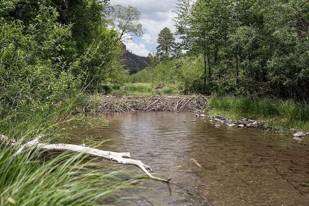
Hube, E-M. (Apr. 24, 2023). Once-common San Pedro River beavers making tiny comeback. Arizona Daily Star. https://tucson.com/news/local/once-common-san-pedro-river-beavers-making-tiny-comeback/article_a30c94da-df12-11ed-8ae4-734100e4eb96.html

    [8] Arizona Department of Water Resources. (May 4, 2023). Restoration project supported by ADWR's Water Protection Fund deemed a 'great success.' https://new.azwater.gov/news/articles/2023-04-05-0


    Salt River Project

    Starting in the 1920s and for the next 30 thirty years Salt River Valley Water Users' Association (SRVWUA) was the leading valley water supplier.[1]

    A 1920 study discovered that the water table was rising 1.5 feet per year. There were about 43,000 acres with a water level of about 10 feet below the surface. To capture that water 33 wells were dug to remove 200,000 acre-feet of groundwater per year. In locations where building wells was not practical ditches were dug to divert excess water.[1]

    The system was divided into 45 divisions under the supervision of water masters. In 1922, a group of Yaqui Indians from Mexico arrived to work on maintenance crews. SRVWUA provided them with permanent housing, and the crews remained into the 1950s.[1]

    There were several floods during the early 1920s, so Phoenix, Maricopa County and SRVWUA funded Cave Creek Dam which stopped a major flood in 1923.[1]

    In the early 1920s other groups on the periphery of the Salt River Project (SRP) attempted water irrigation programs. The Auxiliary Eastern Canal Landowners' Association (ECLA) wanted to buld a dam at Mormon Flat and irrigate 35,000 acres with a combination of floodwater and groundwater, but SRVWUA had a prior water claim to the Salt and Verde water that ECLA wanted.[1]

    Salt River watershed
    Salt River watershed
    Shannon1
    Apr. 22, 2011
    Wikipedia Salt River
    https://en.wikipedia.org/
    wiki/Salt_River_(Arizona)#/
    media/File:Salt_River_Map.jpg
    CC BY-SA 4.0
    In June 1920 the ECLA and SRVWUA reached an agreement that allowed ECLA to expand the canal system in the southern and western parts of the valley, but ECLA later gave up its claim, renamed itself the Roosevelt Water Conservation District (RWCD).[1]

    The Verde River Irrigation and Power District (VRIPD) wanted to divert water that was being used by the SRP, but like ECLA, lacked funding and political support to build the proposed Verde Dam.[1]

    In 1930 groundwater had become scarce, with reservoir storage at close to 100,000 acre-feet. SRP turned to groundwater and installed 45 high-capacity pumping plants in less than a year.[1]

    SRVWUA then had a bonded debt of $11 million for three Salt River dams, and owed the federal government $4.8 million for the balance of the Roosevelt Dam costs. SRVWUA requested another $3.6 million from the federal government, agreeing to pay back all of its federal debts over the next 20 years.[1]

    During and after the Great Depression, SRVWUA managed to maintain its credit rating and managed to collect payments from water users.[1]

    In 1933 the Public Works Administration (PWA) provided the U.S. Bureau of Reclamation, which established an office in Phoenix, $19 million to finance the Verde project. But reports indicated that the project was ill-advised.[1]

    In 1936 the Maricopa County Board of Supervisors approved SRVWUA's request to form the Salt River Project Agricultural Improvement and Power District (SRPAIPD), separating the Salt River water and power management functions.[1]

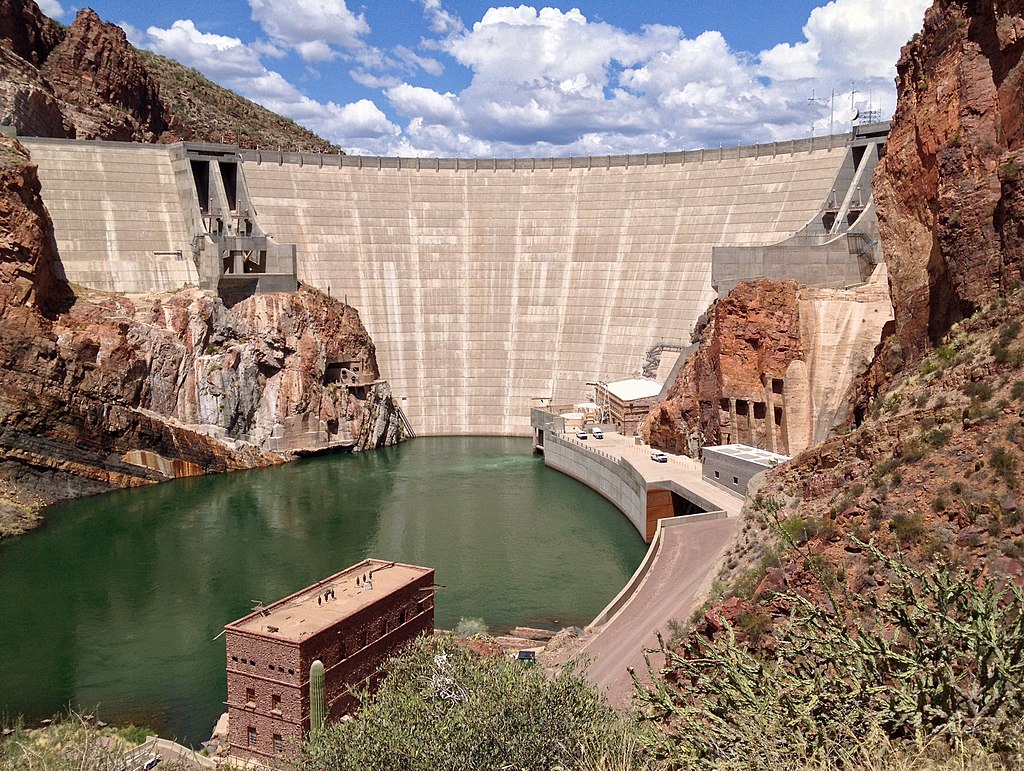
    The Bartlett Dam was started in 1937 and completed in 1939, creating a 2,185 acre reservoir that stored 180,000 acre-feet of water. This dam was financed with federal funds and built by the Bureau of Reclamation, symbolizing the relationships between SRP and the federal government.[1]

    Morenci Mine
    Morenci Mine
    S. Salisbury
    Oct. 14, 2012
    Wikipedia Morenci Mine
    https://en.wikipedia.org/
    wiki/Morenci_mine#/media/
    File:Morenci_Mine_2012.jpg
    CC BY 2.0
    During World War II, there were 20 prisoner-of-war camps in Arizona, with four in the Salt River Valley. Many of the prisoners dug and cleaned SRP ditches. In 1944 25 of them escaped through a tunnel they dug through the Crosscut Canal. They planned on floating down the Salt and Gila Rivers on rafts, but failed due to low water flow, and were recaptured.[1]

    Phelps Dodge Corporation needed additional water for its Morenci mining operations on the Gila River in southeastern Arizona, In 1944 construction on the Horseshoe Dam, paid for by Phelps Dodge, began. It is the only earth and rockfill dam in the SRP system.[1]

    In 1947 21-year-old University of Arizona graduate, Louisa Simons, became SRP's first female engineer.[1]

    By the end of WW I, the Phoenix area economy was booming. In 1948 the percentage of SRP customers increased by 28.5% because of new housing subdivisions and new businesses.[1]

    The SRP dam system developed over several decades:[2]

    Urbanization created a new problem. Ditches and canals became traffic hazards and trash and weed collectors. By 1954 seven miles of canals and were lined with concrete and 28 miles of ditches were replaced with pipes at a cost of $40,000 per mile. They became separations for new roads and subdivisions.[1]

    Salt water meets fresh water at what?
    SRP provided subdivision homeowners who now lived on land previously used for agriculture with an interesting service. SRP had supplied irrigation water to farmlands and continued to direct water every two weeks onto subdivision property for owners who wanted it. The lots were watered for 30 to 90 minutes, creating temporary desert lagoons for bathing birds and floating insects. But the cost became prohibitive, and was ended in 1955.[1]

    In the 1960s, the metropolitan area needed new water resources, which then included treated wastewater released into the Salt River bed.[1]

    How many U.S. public water systems?
    In 1975, increasing water and power costs drove up SRP's rates by 50%.[1]

    In February 1980 three heavy rainstorms put enormous pressure on the entire SRP dam system. Roads washed out and power houses were flooded. SRP released 180,000 cubic feet per second from the system, the largest controlled flow ever to go down the Salt River, to avoid reservoir flooding.[1]

    The Ninth Circuit Court of Appeals James, et al. v. Ball, et al., 613 F.2d 180 (1979) decision challenged the way that SRP allowed its membership to vote. In 1981 the U.S. Supreme Court overruled the Appeals Court and ruled in SRP's favor, and landowners who had more acreage had greater voting rights.[1]

    Phoenix
    Phoenix
    Melikamp
    Nov. 27, 2011
    Wikipedia Phoenix
    https://en.wikipedia.org/
    wiki/Phoenix,_Arizona#/media/
    File:Phoenix_AZ_
    Downtown_from_airplane.jpg
    CC BY-SA 3.0
    Tribal water rights became an important issue in resolving claims for all water users. Water rights of Indian and non-Indian communities were based on different legal precedents and resolving the water claims of Arizona's Tribes was imperative in determining SRP's future. Litigating Tribal claims was time-consuming and expensive. The legal outcomes could affect water access of non-tribal users, so it was in SRP's best interest to negotiate and resolve Tribal water rights before they ended up in court.[1]

    The 1988 Salt River Pima-Maricopa Indian Community Water Rights Settlement agreement provided the Tribe with financial support for water use planning and agricultural and industrial development. It also served as a model for future agreements with the Fort McDowell Indian Community in 1993, the San Carlos Apache Tribe in 1999 and the Zuni Tribe on the Little Colorado and the Gila River Indian Community (GRIC) in 2002.[1]

    During the next 30 years, SRP dealt with an increasing customer base as the population of the "Valley of the Sun" increased by several million. SRP celebrated its 100th anniversary in 2003. A drought significantly reduced the Roosevelt Lake water supply, and as the water level decreased, willow and salt cedar trees began lining its banks, becoming a home for several bird species including the endangered southwestern willow flycatcher.[1]

    If and when the water level increased, this new bird environment would be eliminated, so SRP received a permit from the US Fish and Wildlife Service to offset the impacts to the flycatchers and three other protected bird species. SRP created the Roosevelt Lake Habitat Conservation Plan, establishing 2,200 acres of permanent flycatcher habitat in riparian zones across central Arizona to provide the birds with a new and more permanent home.[1]

    In 2004 Congress passed the Arizona Water Settlements Act that resolved many of Arizona's water issues and resolved tribal water disputes.[1]

    In 2010 the White Mountain Apache Water Rights Quantification Settlement Judgment and Decree ended conflicts between SRP, the state and the Tribe. This agreement was of special importance because the headwaters of the Salt River are on Apache land.[1]

    SRP remains a community-based nonprofit utility annually supplying nearly 800,000 acre-feet of water and power to more than a million customers.[1]

    Sources:

    The Salt River Project
    Salt River Project
    Mar. 10, 2016
    YouTube
    https://www.youtube.com/watch?v=6O5jVwiEHUY
    Embedded video, no copy made
    [1] Superior Court. (Dec. 8, 2014). White Mountain Apache Tribe water rights quantification settlement judgment and decree. State of Arizona.
    https://www.superiorcourt.maricopa.gov/SuperiorCourt/
    GeneralStreamAdjudication/docs/6417-202%20White%20Mountain%20Apache%20%20Settlement%20
    Judg%2012.18.14.pdf

    [2] Salt River Project. (2020). Dams and reservoirs managed by SRP. https://www.srpnet.com/water/dams/

    [3] Salt River Project. (2020). Theodore Roosevelt Dam. https://www.srpnet.com/water/dams/roosevelt.aspx

    [4] Salt River Project. (2020). Horse Mesa Dam. https://www.srpnet.com/water/dams/horsemesa.aspx

    [5] Salt River Project. (2020). Mormon Flat Dam. https://www.srpnet.com/water/dams/mormon.aspx

    [6] Salt River Project. (2020). Stewart Mountain Dam. https://www.srpnet.com/water/dams/stewart.aspx

    [7] Salt River Project. (2020). Horseshoe Dam. https://www.srpnet.com/water/dams/horseshoe.aspx

    What Arizona city recently lost its Scottsdale water supply?
    [8] Salt River Project. (2020). Bartlett Dam. https://www.srpnet.com/water/dams/bartlett.aspx

    [9] Salt River Project. (2020). Granite Reef Diversion Dam. https://www.srpnet.com/water/dams/granitereef.aspx

    [10] Salt River Project. (2020). C.C. Cragin Dam and Reservoir. https://www.srpnet.com/water/dams/cragin.aspx


    Drought

    Tier 1 shortage
    Tier 1 shortage
    Central Arizona Project
    2022
    Water/CAP System/Planning and Processes/Shortage Impacts
    https://www.cap-az.com/water/cap-system/
    planning-and-processes/shortage-impacts/
    Used with written permission of
    Central Arizona Project
    Southwestern North America has been suffering a megadroughta drought lasting for more than two decades since 2000. The current drought has exceeded the severity of a late-1500s megadrought identified as the driest in 1,200 years. Several wet years are required to alleviate the drought it would take multiple wet years to remediate the drought.[16]

    Researchers analyzing tree rings from southern Montana to northern Mexico and between the Pacific Ocean and the Rocky Mountains identified past moisture levels and found that severe droughts were marked by a lack of soil moisture. They also discovered that megadroughts occurred repeatedly in that region between 800 and 1600, confirming that droughts were a natural occurence.[16]

    But climate change has made droughts far worse than those of the past. Human-caused climate change responsible for about 42% of the soil moisture deficit since 2000. Warmer temperatures increase evaporation, drying soil and vegetation.[16]

    The 2004 Arizona Drought Preparedness Plan created the Drought Interagency Coordinating Group. The group includes representatives from state, federal and non-governmental organizations. They identify drought mitigation and adaptation options, advise the governor about drought conditions, request drought declarations, review and approve the Arizona Drought Preparedness Plans & Annual Reports and make recommendations on drought monitoring and response implementation.[19]

    In 2018 and early 2019 Arizona Department of Water Resources (ADWR) and Central Arizona Project (CAP) led nearly 40 stakeholders through months of public and small group meetings with the goal of negotiating reductions from Colorado River allocations.[4]

    In 2020 and 2021 the river operated at Tier Zero status, requiring Arizona to forego 192,000 acre-feet of the state's 2.8-million acre-foot annual entitlement to Lake Mead. The reduction was entirely from the CAP system.[3]

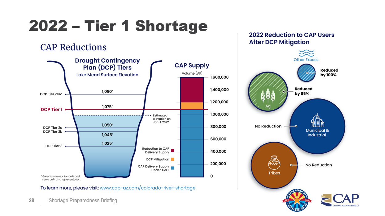
    In August 2021 the U.S. Secretary of the Interior declared the first-ever Tier 1 shortage for Colorado River operations requiring Arizona to further reduce uses to a total of 512,000 acre-feet from the CAP.[3]

    Arizona has how many miles of rivers?
    Tier 1 reductions constitute about 30% of CAP's normal supply, about 18% of Arizona's Colorado River supply and less than 8% of Arizona's total water use.[3]

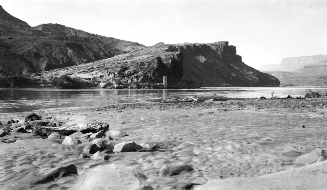
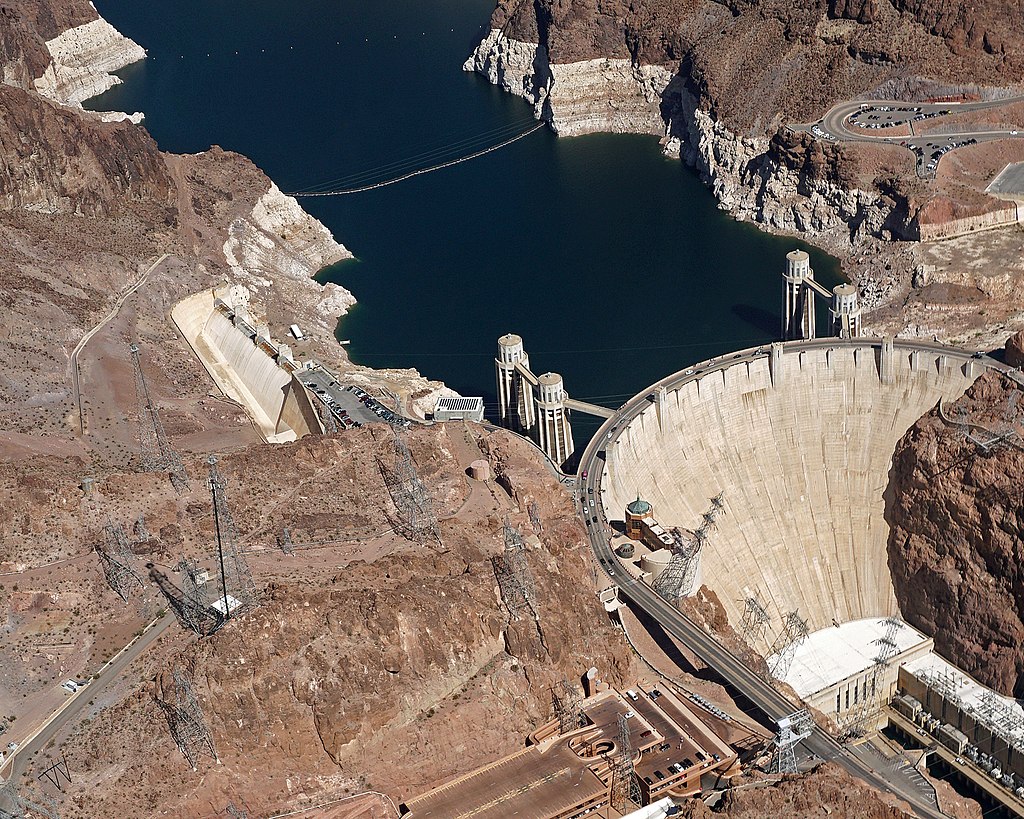
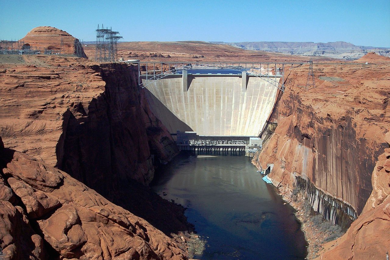
    On February 14, 2023 Lake Powell, about 22% full, dropped to a record low of 3,522 feet above sea level, the lowest it has been since it was filled in the 1960s. The level is expected to continue declining until May, when mountain snowmelt will join streams flowing into the lake.[10]

    The bottom of Lake Powell is now covered by a layer of Colorado River sediment, estimated to be at least 100 feet thick. The layer is called the Dominy formation, named after Floyd Dominy, who led Glen Canyon Dam construction as the head of the Bureau of Reclamation. Dominy claimed that it would take thousands of years for the reservoir to fill with sediment.[11]

    Tier 2 shortage
    Tier 2 shortage
    Central Arizona Project
    2023
    Water/CAP System/Planning and Processes/Shortage Impacts
    https://www.cap-az.com/water/cap-system/
    planning-and-processes/shortage-impacts/
    Used with written permission of
    Central Arizona Project
    When exposed this broken sediment, which has captured tons of water, releases methanea powerful greenhouse gas and the simplest hydrocarbon, consisting of one carbon atom and four hydrogen atoms from rotting trees. During flash floods, the muddy layer flows downstream with its captured biomatter,mass of living matter within a given area damaging ecosystems, displacing and killing both flora and fauna, including otters, native fish, willows and cottonwoods.[11]

    In 2022, Cathedral in the Desert, a feature that has not been visible since the 1960s, could be accessed by boat. By 2023 visitors had to secure boats downstream and walk 15 minutes along a small creek through which even small boats cannot pass. As the reservoir continues to decline, the journey by foot will increase.[11]

    Some environmentalists view Lake Powell's decreasing water supply as an opportunity for the area to return to its natural state, before the Glen Canyon Dam was built. Because the water level has declined, however, hydropower turbines are now using warm surface water, making conditions more hospitable for non-native fish which are competing with native species.[11]

    The seven Colorado River Basin States, along with water entitlement holders in the Lower Basin, developed Upper Colorado River Basin Drought Contingency Plan and a Lower Colorado River Basin Drought Contingency Plan.[1] The Upper and Lower Basins of the Colorado were each allocated 7.5 million acre-feet of water.

    The Upper Basin plan is designed to:

    Lower Colorado drought contingency plan Lake Mead contributions
    Lower Colorado drought contingency plan Lake Mead contributions
    Central Arizona Project
    Drought Contingency Plan
    https://www.cap-az.com/water/water-supply/
    protecting-cap-reliability/drought-contingency-plan/
    Used with written permission of
    Central Arizona Project
    The Lower Basin plan is designed to: In a companion agreement, the states:

    On August 16, 2022 the Department of the Interior declared that the Colorado River will operate in a Tier 2 shortage condition starting in January, 2023. The Department estimated that Lake Mead's water level will fall below 1,050 feet above sea level, the Tier 2 threshold.[5]

    A Bureau of Reclamation and Western Illinois University study concluded that it was possible and extremely expensive to move water from the Mississippi River to the drought-stricken west, but at $1,700 per acre-foot requiring an 88-foot diameter pipe. And there are no guarantees that the Mississippi will not experience drought.[12]

    The Arizona Department of Water Resources provides extensive resources on the current conditions of the Colorado River.[2]

    Colorado River Shortage: Tier 2a for 2023
    Central Arizona Project
    Sep. 8, 2022
    YouTube
    https://www.youtube.com/watch?v=10xVK_xfJuE
    Embedded video, no copy made
    Colorado River Studies
    agency title ✔ year
    Bureau of Reclamation Colorado River Basin Ten Tribes
    Partnership Tribal Water Study
    2009
    Bureau of Reclamation Colorado River Basin Water
    Supply and Demand Study
    2009
    USGS Colorado River Basin Studies Present
    Utah State University Colorado River Recently
    Published Research
    Present

    Drought has led to additional problems for some Arizona residents. Rio Verde Foothills is an unincorporated community of about 2,200 homes outside of Scottsdale, which has been trucking water to about 500 Rio Verde homes.[6]

    More than ten years ago Scottsdale warned Rio Verde residents that they would need to find a different water source.[6] In November 2021 Scottsdale notified Rio Verde that the Colorado Tier 1 shortage and the city's drought management plan required the stoppage of water deliveries as of January 2023.[7] Scottsdale officials said their first responsibility was to Scottsdale residents.[6]

    Some Rio Verde property owners banded together to try to create their own water improvement district. But the Maricopa County Board of Supervisors voted down their petition, citing other residents' objections that claimed properties could be condemned to build a new water delivery system.[6]

    In October 2022 Canada-based water company, Epcor Utilities, filed an application to supply Rio Verde Foothills with water. If the project were approved the utility would have to purchase land and construct a standpipe and drill a new well, which could take two to three years. Only homes built before 2024 would receive water provided by Epcor.[6]

    Megadroughts projected for American west
    NASA
    Feb. 12, 2015
    YouTube
    https://www.youtube.com/watch?v=ToY4eeWsdLc
    Embedded video, no copy made
    In January 2023 Governor Katie Hobbs released an ADWR report showing that the groundwater basin under Buckeye, west of Phoenix, will fall below the needs of subdivisions scheduled for construction over the next 100 years.[9] Buckeye's population would nearly quadruple in the next several years if all currently proposed developments are approved.[8]

    Hobbs also ordered the creation of a new Water Policy Council, with the goal of updating the 1980 Ground Water Management Act. That act requires subdividers in Maricopa, Pinal and Pima counties to prove that 100 years of assured water supply exist for proposed housing developments.[8] That proof must include legal availability, financial availability, good quality, physical availability and renewable resource availability.[15]

    January 2023 snows provided a slight improvement to Arizona's drought situation. At the Verde River watershed snowpack as of February 1, 2023 was about 300% of normal and twice winter's usual peak accumulation. SRP predicted that Horseshoe and Bartlett reservoirs will fill to capacity and spill as much as 100,000 acre-feet.[13]

    In February 2023 the Mesa City council approved $3.4 million for funding to on drill 12 new groundwater wells by 2029. On March 6, 2023 the council decided to spend $13 million to build a new 10-mile pipeline to deliver some city reclaimed water to the Gila River Indian Community.[14]

    At the Salt River watershed snowpack was about 111% of normal and about 95% of the typical winter peak. SRP's 2023 prediction states that Roosevelt Lake will reach approximately 90% capacity in spring 2023.[13]

    What are the three Lower Basin states?
    Alleviating the effects of the drought requires action and cooperation among Colorado River basin states:

    Sources:

    [1] Arizona Department of Water Resources. (n. d.). Colorado River Drought Contingency Planning June 28, 2018 - Present. https://new.azwater.gov/lbdcp

    [2] Arizona Department of Water Resources. (n. d.). Colorado River Current Conditions. https://new.azwater.gov/crm/dashboard

    [3] Central Arizona Project. (2022). Colorado River Shortage 2022 Fact Sheet. https://new.azwater.gov/sites/default/files/media/ADWR-CAP-FactSheet-CoRiverShortage-081321.pdf

    What are the four Upper Basin states?
    [4] Central Arizona Project. (Feb. 2022). Drought Contingency Plan Fact Sheet. https://library.cap-az.com/documents/departments/planning/colorado-river-programs/CAP-FactSheet-DCP.pdf

    [5] Nilsen, E. and Ramirez, R. (Aug. 16, 2022). New water cuts coming for Southwest as Colorado River falls into Tier 2 shortage. CNN. https://www.cnn.com/2022/08/16/us/colorado-river-water-cuts-lake-mead-negotiations-climate/index.html

    [6] Hampton, D. J. (Nov. 17, 2022). Faucets poised to run dry for hundreds of Arizona residents by year's end. NBC News. https://www.nbcnews.com/news/us-news/faucets-poised-run-dry-hundreds-arizona-residents-years-end-rcna57550

    [7] Schneider, V. (Nov. 1, 2021). Water hauling to halt January 2023 for non-residential customers. City of Scottsdale. https://s3.documentcloud.org/documents/21176854/rvf-water-hauling-letter-from-scottsdale.pdf

    One of the first federal reclamation programs was?
    [8] Davis, T. (Jan. 10, 2023). Pima County among areas that could face water messes like Buckeye's. tucson.com. https://tucson.com/news/local/subscriber/pima-county-among-areas-that-could-face-water-messes-like-buckeyes/article_67ea20e6-90a4-11ed-9193-d3dc2db28bcc.html

    [9] Myskow, W. (Jan. 17, 2023). Arizona's new governor take on water conservation and promises to revise the state's Groundwater Management Act. Inside Climate News. https://insideclimatenews.org/news/17012023/arizonas-katie-hobbs-groundwater-policy-buckeye-scottsdale/#:~:text=Jan%2017%2C%202023-,Arizona's%20new%20governor%20takes%20on%20water%20
    conservation%20and%20promises,the%20state's%20Groundwater%20Management%20Act&text=As%20Gov.,
    groundwater%20use%20in%20rural%20areas.

    [10] Water Education Foundation. (Feb. 16, 2023). Lake Powell drops to a new record low as feds scramble to prop it up. https://www.watereducation.org/aquafornia-news/lake-powell-drops-new-record-low-feds-scramble-prop-it#:~:text=Water%20levels%20fell%20to%203%2C522.16,record%20set%20in%20April%202022.

    Where are the headwaters of the Colorado River?
    [11] Childs, C. (Feb. 1, 2023). Glen Canyon revealed. High Country News. https://www.hcn.org/issues/55.2/features-water-glen-canyon-revealed

    [12] The Daily Sentinel. (Feb. 9, 2023). The Mississippi won't save us. Grand Junction, Colorado. https://www.gjsentinel.com/opinion/editorials/the-mississippi-wont-save-us/article_5a32bc08-a808-11ed-a46d-971258140734.html

    [13] Water Use It Wisely. (Feb. 23, 2023). Celebrate AZ water: A tale of two watersheds. https://wateruseitwisely.com/blog/celebrate-az-water-a-tale-of-two-watersheds/

    [14] Reagan, K. (Mar. 7, 2023). Mesa spending millions on new water infrastructure after declaring shortage. 12News. https://www.12news.com/article/news/local/water-wars/mesa-spending-34m-drilling-new-groundwater-wells/75-006a4af4-22ee-44d8-918c-e1544d707908#:~:text=MESA%2C%20Ariz.,the%20southeast%20region%20of%20Mesa.

    [15] Arizona Department of Water Resources. (n. d.). Arizona water facts. https://www.arizonawaterfacts.com/water-your-facts

    Who was the Salt River Project`s first female engineer?
    [16] Columbia Climate School. (Feb. 14, 2022). Megadrought in Southwest is now the worst in at least 1,200 years, study confirms. https://news.climate.columbia.edu/2022/02/14/megadrought-in-southwest-is-now-the-worst-in-at-least-1200-years-study-confirms/

    [17] Kaufman, M. (Aug. 4, 2021). 'When will the megadrought end?' is the wrong question to ask. Mashable Voices. https://mashable.com/article/drought-megadrought-what-to-do

    [18] Las Vegas Valley Water District. (n. d.). Drought and conservation measures. https://www.lvvwd.com/conservation/measures/index.html

    [19] Arizona Department of Water Resources. (Oct. 2016). Arizona drought interagency coordinating group. https://infoshare.azwater.gov/docushare/dsweb/Get/Document-9990/ICG%20Fact%20Sheet%202016.pdf


    Central Arizona Project: 30 Years of Shaping Arizona
    Central Arizona Project
    Jul. 21, 2015
    YouTube
    https://www.youtube.com/watch?v=3x1FOPDFISQ
    Embedded video, no copy made

    Central Arizona Project

    In 1968 President Lyndon B. Johnson signed the Colorado River Basin Project Act, authorizing construction of CAP by the U.S. Department of the Interior's Bureau of Reclamation. The system enabled 1.5 million acre-feet of Arizona's allotment to be delivered to population centers and reduced groundwater for agriculture and other activities.[1]

    In 1971 the Central Arizona Water Conservation District (CAWCD) was created to provide Arizona a means to repay the federal government for the reimbursable costs of construction and to manage and operate the physical system. CAWCD is usually referred to as Central Arizona Project (CAP).[1] CAWCD consists of Maricopa, Pima and Pinal counties.[2]

    CAP is a non-profit public utility governed by a 15-member volunteer board of directors. Ten are elected from Maricopa, four from Pima, and one from Pinal counties. They meet twice per month and serve six year terms.[1]

    CAP's operations are managed by a staff of 500, responsible for maintenance, operations, business management, public outreach and resource management.[1]

    CAP construction cost $4 billion. It began at Lake HavasuLake Havasu with Lake Havasu City
    Lake Havasu with Lake Havasu City,
    Arizona on the east shore
    D. Searls
    Sep. 23, 2007
    Wikipedia Lake Havasu
    https://en.wikipedia.org/
    wiki/Lake_Havasu#/media/
    File:LkHavasu.jpg
    CC BY-SA 2.0
    in 1973 and was completed 20 years later south of Tucson.[1]

    Central Arizona Project canal shape
    Central Arizona Project canal shape
    Central Arizona Project
    https://knowyourwaternews.com/why-the-cap
    -canal-shape-matters-a-tale-of-the-trapezoid/
    Used with written permission of
    Central Arizona Project
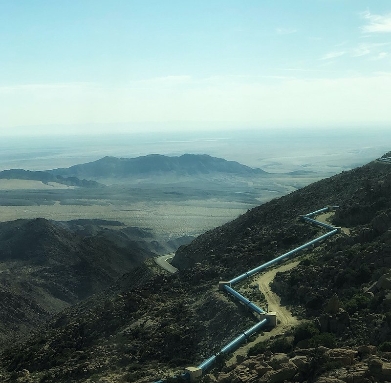
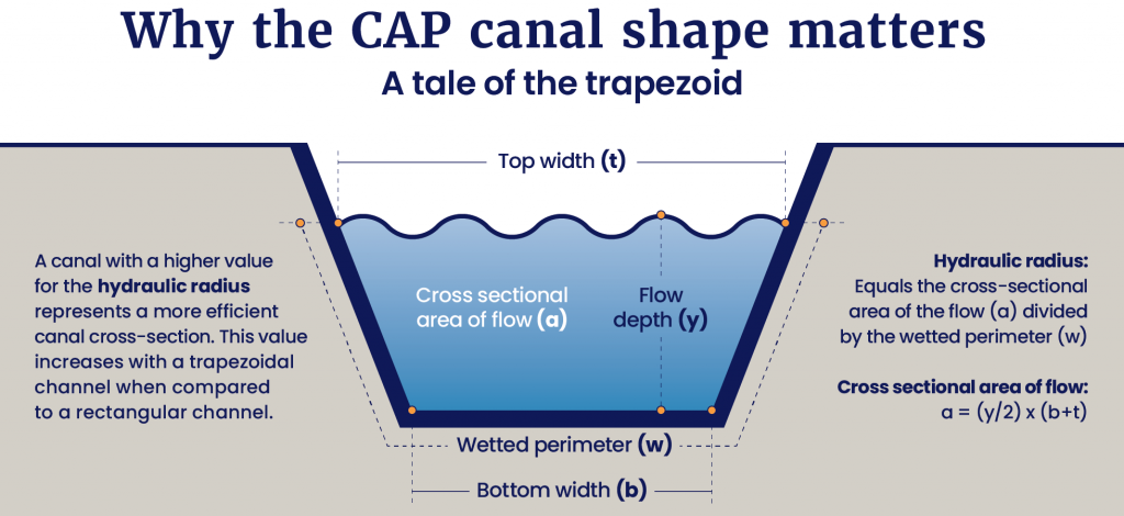
    CAP is the state's single largest power user, utilizing 2.5 million megawatt1,000 kilowatts, the power used by the average microwave oven hours per year, about the same amount of energy used by 250,000 homes. The system pumps water uphill from the Mark Wilmer Pumping Plant. Six 66,000 horsepower pumps force water up 800 vertical feet into the seven-mile long Buckskin Mountain Tunnel. The water then flows into and continues through the canal to Tucson.[1]

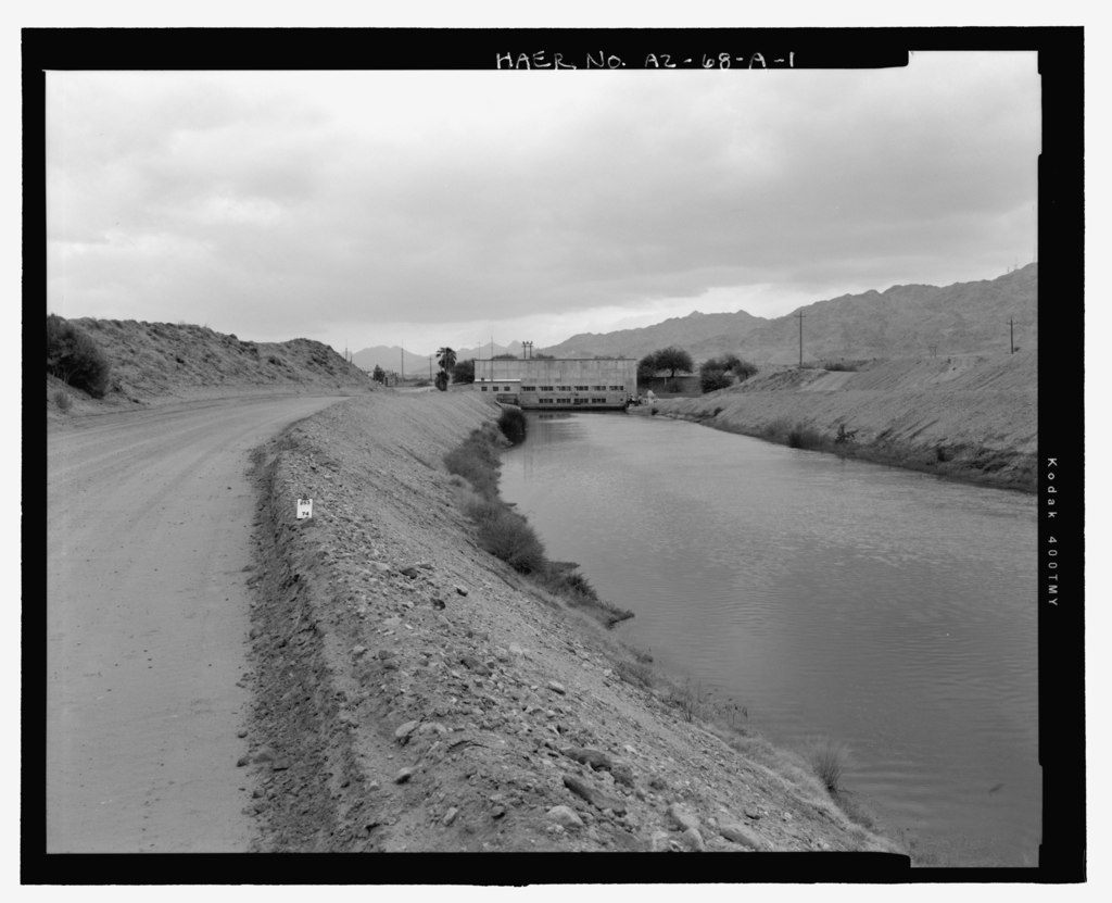
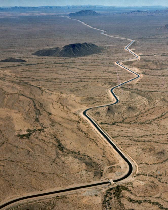
    The canal is 336 miles long. The system has 39 check structures acting as a metering devices, controlling the flow of water into and out of parts of the canal. Each check structure contains two independently operating gates that can move in 1/100 foot increments. The maximum structure capacity is 3,000 cubic feet per second.[13]

    Fourteen pumping plants lift the water more than 2,900 feet before it starts its journey to Tucson, which takes between five and seven days. On its way, the water passes through the hydroelectric pump and generating plant at New Waddell Dam,New Waddell Dam
    New Waddell Dam
    U.S. Bureau of Reclamation
    May 31, 2011
    Wikipedia New Waddell Dam
    https://en.wikipedia.org/
    wiki/New_Waddell_Dam#/media/
    File:New_Wadell_Dam.jpg
    public domain
    the Lake Pleasant storage reservoir and 39 gates controlling water flow. There are also 50 water delivery turnouts.[1]

    The first part of the canal system is wider and deeper, acting as an internal reservoir, holding 20% of the system water. The canal descends approximately 5 inches per mile. On its way, about 1% of the annual flow, 16,000 acre-feet per year, is lost to evaporation.[1]

    Some Arizonans have wondered why CAP isn't covered by solar panels to prevent evaporation, 16,000 acre-feet per year. A study by the Bureau of Reclamation and CAP concluded that they would be difficult to construct and maintain, would need to be adjusted to track the Sun, and would cost about $4 billion to install.[11]

    CAP water is used for residential, business and tribal customers and agriculture for irrigation.[1]

    Central Arizona Project canal
    Central Arizona Project canal
    Central Arizona Project
    Mar. 26, 2008
    Wikipedia Central Arizona Project
    https://en.wikipedia.org/
    wiki/Central_Arizona_Project#/
    media/File:Arizona_cap_canal.jpg
    public domain
    CAP generates revenue by selling water and power, usage fees paid by customers, investments, and property taxes paid by non-Indian reservation residents of Maricopa, Pima and Pinal counties. Water prices are determined by the CAWCD board of directors who use energy, operations, maintenance, and replacement cost projections, but must be reasonable and affordable.[1]

    The Arizona Reconsultation Committee (ARC) meets monthly to discuss the state of the CAP system, reevaluate previous plans and agreements, conservation efforts, and water renewal projects.[3]

    CAP also has an extensive plan for the possible introduction of non-CAP water, called non-project water. CAP continues to work with Arizona cities and tribes, asked for, and received a lot of positive feedback on its potential plans.[4]

    CAP was recently awarded VESP Platinum, the highest level of ADEQ's Voluntary Environmental Stewardship Program (VESP). To achieve VESP Platinum, CAP achieved a measurable environmental improvement, committed to measuring continuous improvement for three years, instituted an active Environmental Management System, and committed community outreach.[5]

    On November 18, 2020, CAP University held its first class. More than 300 members of the public from several Upper and Lower Colorado Basin states signed on to the 3-hour Zoom meeting which addressed CAP background and history, engineering, land development, power usage, drought contingency plan, sustainability efforts, and the steps that CAP takes to keeps its on-site and field employees safe.[6]

    CAP is planning additional CAP University courses that will explore each of these topics in greater depth.[7]

    CAP is part of Water Utility Climate Alliance (WUCA), a coalition of 12 of the nation's largest water providers. WUCA member agencies provide drinking water to more than 50 million people in the U.S. Other members include Austin Water, Denver Water, Metropolitan Water District of Southern California, New York City Department of Environmental Protection, Philadelphia Water Department, Portland Water Bureau, San Diego County Water Authority, San Francisco Public Utilities Commission, Seattle Public Utilities, Southern Nevada Water Authority and Tampa Bay Water. WUCA engages in climate change research, water management decision-making improvement and water supply protection.[9]

    The CAP Trail: Arizona's multi-use recreational opportunity
    Central Arizona Project
    Jun. 3, 2021
    YouTube
    https://www.youtube.com/watch?v=lwoK7aQwkRM
    Embedded video, no copy made
    CAP is home to many fish, including largemouth and smallmouth bass, bluegill, redear sunfish, striped bass and carp which enter as eggs or larvae at Lake Havasu and Lake Pleasant. Grass carp and channel catfish are stocked annually for vegetation and insect control. When sections of the canal are drained for maintenance the fish usually detect equipment motion and move. CAP crews rescue any remaining fish before work begins and transport them upstream or downstream to a safe canal location.[10]

    In early October 2023, a hungry crew of goats arrived at Superstition Mountains Recharge Project. They spread out over the basin and began their three-month weed eating efforts. The goats are provided with a trough of fresh water and the basin is surrounded by an electric fence netting to keep the goats from wandering and safe from predators. The goats will leave underlying soil exposed, increasing drainage and removing weeds that would clog the basin. The herd may be used on five other projects owned and operated by CAP.[12]

    To learn more about the CAP sign up for Central Arizona Project Know Your Water News[8] and check out the CAP allocations map.[14]

    Sources:

    [1] Central Arizona Project. (n. d.). Background and history. https://www.cap-az.com/about-us/background

    Goats at Superstition Mountains recharge
    Central Arizona Project
    Oct. 18, 2023
    YouTube
    https://www.youtube.com/watch?v=YkH6Z5htHz0
    Embedded video, no copy made
    [2] Arizona Library, Archives, and Public Records. (n. d.). Central Arizona Water Conservation District (CAWCD). https://azlibrary.gov/sla/agency_histories/central-arizona-water-conservation-district-cawcd

    [3] Central Arizona Project. (n. d.). Arizona Reconsultation Committee (ARC). https://www.cap-az.com/departments/planning/colorado-river-programs/arizona-reconsultation-committee

    [4] Central Arizona Project. (Apr. 9, 2020). Draft water quality guidance for the introduction of non-project water into the Central Arizona Project. https://library.cap-az.com/documents/departments/planning/service-area-planning/water-quality-guidance-draft-102620.pdf

    [5] Arizona Department of Environmental Quality. (Nov. 12, 2020). Central Arizona Project is now a platinum member of the ADEQ Voluntary Environmental Stewardship Program. Press Release. http://www.azdeq.gov/press-releases/vesp-cap

    [6] Central Arizona Project. (Nov. 2020). CAP University resources. https://www.cap-az.com/cap-university-resources

    [7] Person, D. (Nov. 30, 2020). Zoom interview.

    When did the Salt River Valley Water Users Association (SRVWUA) form?
    [8] Central Arizona Project. (n. d.). Know Your Water News. https://knowyourwaternews.com/

    [9] Person, D. (Sep. 19, 2022). CAP is WUCA's "poster child" for September! Central Arizona Project Know Your Water News. https://knowyourwaternews.com/cap-is-wucas-poster-child-for-september/

    [10] Bryan, S. (Jan. 16, 2023). Saving the fish. Know Your Water News. https://knowyourwaternews.com/saving-the-fish/

    [11] Walter, N. (Aug. 29, 2022). Why the CAP isn't covered by solar panels. Know Your Water News. https://knowyourwaternews.com/why-the-cap-isnt-covered-by-solar-panels/

    How many miles long is the CAP canal?
    [12] Central Arizona Project. (n. d.). Got weeds? Know Your Water News. https://knowyourwaternews.com/goat-weeds/

    [13] Central Arizona Project. (n. d.). Anatomy of a check structure. Know Your Water News. https://knowyourwaternews.com/check-1-2-3/

    [14] Central Arizona Project. (n. d.). CAP allocations map. https://library.cap-az.com/maps/capallocations


    Groundwater

    In the last 60 years, Arizona's population has grown about 500%, to about 7 million residents. Arizona's water use has declined to less than 7 million acre-feet per year, 3% less than it was in the 1950s.[1]

    The 1980 Groundwater Management Act (GMA) required that its active-management areas (AMAs) find water alternatives other than pumping it out of the ground. This requires conservation efforts by municipal, industrial, and agricultural users which lead to declining per person water use.[2]

    The act established four AMAs:

    More than 75% of Arizonans live within the Prescott, Phoenix, Pinal, Tucson and Santa Cruz AMAs. [2] On July 1, 1994, the boundaries of the Tucson AMA were modified to exclude part of the upper Santa Cruz valley sub-basin included within the Santa Cruz AMA.[26] Four of the five urban AMAs are required to reduce groundwater reliance so that by 2025, they create a balance between recharge and extraction.[1]

    The act was not created without some controversy. It was the first of its kind in the country, outlawing irrigation on any new acres of farmland and forced subdivisions in more populated areas to show a 100-year water supply before building.[3]

    Arizona
    Arizona
    USGS
    2001
    University of Texas Libraries
    https://commons.wikimedia.org/
    wiki/File:Arizona_ref_2001.jpg
    public domain
    Arizona was depleting underground aquifers. A 1976 state Supreme Court decision on groundwater pumping threatened to decimate Tucson's mining industry. Governor Bruce Babbitt and the state legislature managed to work together to pass this act that assured that Arizona had water, when other states, especially California, were dealing with shortages.[3]

    ADWR measures groundwater levels in Arizona basins on a rotating basis. AMAs and irrigation non-expansion areas (INA)area designated to protect existing agriculture where groundwater is the main water source have priority. These efforts, called basin sweeps, collect well water, groundwater and water quality data used in water management and planning.[16]

    The GMA created the Joseph City and Douglas INAs.[28] The Douglas INA became and AMA in 2022. The Harquahala INA was created in 1981 and the Hualapai Valley INA in 2022, They are administered by ADWR.[21]

    On June 28, 2021, ADWR updated groundwater conditions in the Pinal AMA. The results demonstrated that between 2016 and 2115 groundwater demand would exceed supply by 8 million acre-feet.[15]

    In January 2023, ADWR published the Hassayampa Groundwater Model, which projects water use west of the White Tank mountains and northwest of Phoenix. The analysis determined that demand would exceed supply by 4.4 million acre-feet of groundwater over a 100-year period for the area, meaning that future subdivisions relying on groundwater would not be approved.[15]

    Outside AMAs there are few groundwater use restrictions, resulting in limited legal protections for local communities that want to prevent new and existing groundwater user from overpumping, reducing groundwater reserves and creating potential shortages.[2]

    Counties and municipalities outside AMAs can sign up for additional protections. Cochise and Yuma Counties and Clarkdale and Patagonia require new development to prove it can meet the 100 year water requirements of AMAs.[2]

    The San Pedro and the Verde Rivers flow because of groundwater, but Arizona water law does not adequately protect the relationship between groundwater and surface water.[2]

    When Colorado River supply exceeds demand, municipalities can store the excess water underground, earning long-term storage credits. The state tracks those credits, and cities can then return that water into the ground when needed. Reclaimed water, however, earns fewer storage credits.[2]

    In 1993 the Arizona State legislature created a groundwater replenishment authority to be operated by the Central Arizona Water Conservation District (CAWCD) throughout its three-county service area. This replenishment authority of CAWCD is called the Central Arizona Groundwater Replenishment District (CAGRD).[4]

    CAGRD member land development process
    CAP Arizona
    Oct. 2, 2017
    YouTube
    https://www.youtube.com/watch?v=fDv1iw7nRBQ
    Embedded video, no copy made
    CAGRD provides a way for landowners and water providers to demonstrate an assured water supply under Assured Water Supply Rules (AWS Rules) which became effective in 1995.[4] Homeowners can determine if their water utility is part of CAGRD using the map available on the CAP website.[8]

    CAP's Non-Indian Agricultural (NIA) supplies are 65% of CAGRD's water supply portfolio, They were reduced in the 2022 Tier 1 shortage and will be eliminated in the 2023 Tier 2a shortage. Other CAP supplies may be reduced in the future.[11]

    CAGRD has been preparing for less CAP water by acquiring long term storage credits (LTSC), which have enabled CAGRD to acquire reliable assets meeting replenishment obligations for 20 years in the Phoenix AMA, and longer in the Tucson and Pinal AMAs, even under severe shortage conditions.[11]

    Every 10 years, as part of its mandatory operation plan, CAGRD sets a target for LTSCs that should be maintained as a water supply reserves. The reserve target for each AMA is equivalent to 20% of the difference between the total 100-year replenishment obligation for that AMA and the total volume of long- and intermediate-term water supplies planned to meet the obligation.[11]

    When was Camp McDowell established?
    As of 2021, CAGRD's Replenishment Reserve account has 250,000 credits in the Phoenix AMA, 5,800 in the Pinal AMA and 40,800 in the Tucson AMA.[11]

    CAGRD's water acquisition program is focused on securing additional water supplies less susceptible to Colorado River shortage conditions. and will continue to forecast and monitor potential shortage impacts and costs.[11]

    In 1996, the state legislature created the Arizona Water Banking Authority (AWBA). Because farms and cities were not using their full CAP allotments and California had been using the excess Colorado River supply, new water banking laws enabled Arizona to store the unused Colorado allotment in recharge facilities to reduce groundwater overdraft.[5]

    At what Lake Mead water surface elevation is a Tier 3 shortage declared?
    The AWBA can perform water banking services for Arizona entities, including loaning previously developed long term storage credits and storing water for them, and can supplement storage of CAP water with effluent or other surface water supplies.[10]

    In 1999, the legislature expanded CAWCD's replenishment authorities and responsibilities, passing the Water Sufficiency and Availability Act.[4]

    Active management areas
    Active management areas
    Arizona Department of Water Resources
    https://new.azwater.gov/news/articles/2016-18-11
    Used with written permission of ADWR
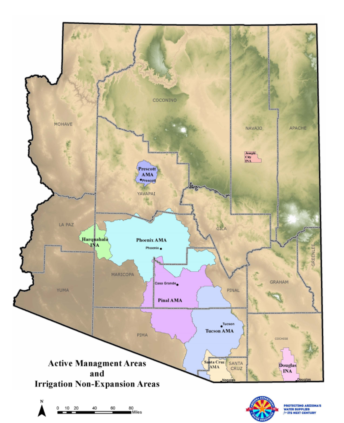
    The USGS monitors groundwater storage and land elevation changes caused by groundwater removal in Tucson Basin and Avra Valley, the two most populated alluvial plainsa largely flat landform created by the deposition of sediment over a long period of time by one or more rivers coming from highland regions, from which alluvial soil forms within the Tucson AMA. It is one of five areas established by the 1980 Groundwater Management Act and governed by the Arizona Department of Water Resources.[6]

    The USGS used radar to track the changes and found the maximum subsidence of about 2 inches occurred between May 2003 to July 2006, and then declined to 0.9 inches between April 2011 and November 2014.[6]

    Between May 2003 and March 2016, maximum subsidence was as high as 5.3 inches in the Tucson metropolitan area, south of Irvington Road between south 12th Avenue and south Park Avenue. Subsidence was as high as 4 inches in central Tucson south of Broadway between Country Club Road and Craycroft Road.[6]

    The radar data indicated that there was no significant land surface deformation from 2003 to 2016 in Avra Valley.[6]

    There are areas of Arizona outside of AMAs, where groundwater sources are declining. Willcox Basin relies on only rainfall alone for replenishment and is vulnerable during drought.[12]

    When large water-using operations, like the Riverview Dairy, moved in to the area residents noticed that their water disappearing because the dairy was pumping out a lot of groundwater from deep wells, causing residents' wells to dry up.[12]

    In 2006 Congress passed U.S. Public Law 109-448 the Transboundary Aquifer Assessment Act, a federally funded program co-hosted by the U.S.G.S. Arizona Water Science Center and the University of Arizona Water Resources Research Center (WRRC).[23]

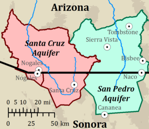
    The act applies to Texas, New Mexico and Arizona, where four transboundary aquifers have been designated for priority assessment. The Hueco Bolson and Mesilla Basin aquifers are in the greater El Paso and Ciudad Juárez region. The Santa Cruz and San Pedro aquifers cross the Arizona-Sonora border.[23]

    Southern Arizona aqufers
    Southern Arizona aquifers
    WRRC
    2023
    Transboundary Aquifer Assessment Program
    https://wrrc.arizona.edu/programs/
    taap-transboundary-aquifer
    -assessment-program
    public domain
    The act's purposes are to develop binational data and information sharing on water quantity, quality and location, aquifer interaction with surface water, facilitate resource assessment and planning.[24]

    A 2018 report from the state water department found that groundwater levels declined by at least 200 feet between 1940 and 2015 in the parts of the Willcox Basin with high agricultural pumping, before Riverview arrived.[12]

    The Willcox Basin groundwater crisis began near the Kansas Settlement and spread across the county as Riverview used more of the aquifers. The crisis now affects Willcox itself, one of the only incorporated settlements in the area, ten miles from the Riverview Dairy.[12]

    Some residents believed that because they lived miles from the dairy, their wells would not be affected, but thousands have experienced dry wells.[13] They are left to haul water from a Willcox facility.[12]

    Overpumping has produced fissures several feet deep. Some have damaged roads, forcing closures and leaving some residents with worthless property and abandoned homes.[12]

    Even as the water crisis grew for years, many residents, spread throughout the county, didn't understand the scale of the water problem created by agribusiness. Opposition to megafarms was initially limited to just a few committed locals. Now, a Willcox Facebook chat has helped to unite residents, who have shown up at county meetings to berate public officials for allowing the dairy to destroy their well water supply.[12]

    After Riverview arrived, county politicians pushed for the creation of a municipal water district, which would create communal wells with a reliable water supply. Residents were suspicious because the proposal was supported by the dairy, which helped finance outreach efforts and office space. Some believed rumors that the dairy was going to create a water district for a new planned community. Creation of the water district has currently stalled.[12]

    Cochise County in 1881
    Cochise County in 1881
    Rand, McNally and Company
    Jan. 1, 1881
    Wikipedia Cochise County
    https://en.wikipedia.org/
    wiki/Cochise_County,_Arizona#/media/
    File:Cochise_County_1881.jpg
    public domain
    Years of anti-regulation sentiment have led to a grassroots campaign for restrictions on new wells which could restrict future corporate farming operations.[12]

    Within the 1980 Groundwater Management Act is a provision allowing rural communities to propose a ballot question about whether to establish an AMA. If the ballot question wins a majority vote, the state then appoints a committee to supervise groundwater in the basin. The committee can impose restrictions on new irrigation activity, limiting land area using groundwater.[12],[27],

    A group called the Arizona Water Defenders wants to create a new AMA to regulate groundwater in the conservative Willcox and Douglas Basins. They had no difficulty obtaining the required 250 signatures from Cochise County residents to get the AMA proposal on the ballot.[12]

    The state paused all new irrigation in the area until after the election, stopping the growth of local agriculture. Individual households will not be restricted because their wells are too small to meet threshold regulations, but local farmers may need to comply with a permitting process to drill new wells.[12]

    A group called Rural Water Assurance, co-founded by the president of the county farm bureau, put up billboards along I-10 urging voters to vote no on the AMA. They also filed a lawsuit against the Douglas Basin AMA effort in June 2022, claiming that collected signature were invalid. The lawsuit was dismissed in August.[12]

    If the AMA is created, it can restrict almost all new pumping, but it can't order current users, including Riverview, to stop drawing well water. Basing groundwater levels will continue to drop. Residents will continue to haul water and dig new wells. Water pumping limitations will deter new farms, further slowing the county's economy.[12]

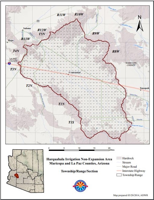
    The Harquahala groundwater basin is located 60 miles west of Phoenix along I-10. It contains approximately 766 square miles of La Paz and Maricopa counties.[20] ADWR estimated that there are between 7 and 8-million acre-feet of water in the Harquahala aquifer.[18]

    Harquahala INA
    Harquahala INA
    Arizona Department of Water Resources
    Mar. 20, 2014
    public domain
    In October 2022 the city of Queen Creek paid $30 million for 500,000 acre-feet of Maricopa and La Paz county water rights for that water. The city plans on using 5,000 acre-feet per year for the next 100 years. The sellers are part of the Harquahala Valley Water Association and will move the water through the CAP canal.[18]

    On November 8, 2022, Cochise County residents approved Proposition 422 to establish an AMA in the Douglas Basin, joining 82% of Arizona where groundwater is managed by an AMA. Voters rejected a measure by a 2-to-1 margin to create a similar management area in the Willcox Basin, where groundwater withdrawal will remain unregulated.[14]

    In January 2023 the city of Buckeye agreed to pay $80 million for an acre of Harquahala Basin and its water rights. The purchase allows Buckeye to use 5,926 acre-feet per year for the next 100 years.[19]

    In 2023 Arizona state attorney general Kris Mayes accused ADWR of failing to protect groundwater, by ignoring its responsibility to study the need for new AMAs. The Saudi firm Fondomonte has been pumping groundwater to grow alfalfa in La Paz county to feed Saudi cattle. Mayes promised to cancel the Saudi lease and stated that the use of Arizona's groundwater by the Saudis is illegal, but governor Hobbs said the cancellation is not legally possible. Mayes successfully managed to get the state land department to cancel two requests by the Saudis to drill two additional wells in La Paz county.[17]

    In June 2023 ADWR released an updated model of groundwater conditions in the Phoenix AMA, consisting of 5,646 square miles and 4.6 million residents. The results showed that over the next 100 years that AMA will have 4.86 million acre-feet of unmet demandoccurs when groundwater can no longer be pumped from a well at the modeled rate due to aquifer depletion for groundwater supplies under current conditions.[22]

    As a result of the study the State will no longer approve new determinations of assured water supply within the Phoenix AMA based on groundwater resources. Developments within existing assured water supply certificates may proceed, but new developments will need to demonstrate that they meet required future water supplies base on other water resources.[22]

    In October 2023, Republicans in the Arizona senate were pointing fingers at each other, stalling water bills and claiming that liberal agendas were taking away water use freedoms. As western Arizona groundwater supplies continue to be depleted by new farms, senators still can't agree how to protect water sources in rural counties.[29]

    In November 2023 the Bipartisan Water Policy Council submitted water recommendations to Governor Katie Hobbs. They recommended closing loopholes to protect water consumers, improve Arizona's Assured Water Supply Program and reforming groundwater management policies in rural Arizona.[30] Under the new policy the state would have more flexible ways to protect rural groundwater decided by management plans based on the needs of specific geographic areas.[31]

    The University of Arizona Project WET provides nine short videos on groundwater storage, pumping, reuse and conservation[7] and the ASU Kyl Center for Water Policy has an app which the public can use to track Arizona's groundwater level changes.[9]

    Sources:

    [1] Arizona Department of Water Resources. (n. d.). AZ's Groundwater Management Act Of 1980. https://new.azwater.gov/news/articles/2016-18-11

    [2] Paul, H. (Oct. 2, 2018). 10 things you should know about Arizona's Groundwater Management Act. Audubon Society. https://www.audubon.org/news/10-things-you-should-know-about-arizonas-groundwater-management-act

    [3] Allhands, J. (May 13, 2019). What you don't know about the water law that saved Arizona. The Republic. https://www.azcentral.com/story/opinion/op-ed/joannaallhands/2018/01/04/lessons-groundwater-management-act-saved-arizona/1000061001/

    [4] Central Arizona Groundwater Replenishment District. (n. d.). Welcome to CAGRD. https://www.cagrd.com/

    What are Arizona's five AMAs?
    [5] Salt River Project. (2017). The Story of SRP: Water, power, and community. https://www.srpnet.com/about/history/StoryofSRP_HistoryBook.pdf

    [6] Carruth, R. L., et al. (2018). Groundwater-storage change and land-surface elevation change in Tucson Basin and Avra Valley, South-Central Arizona-2003-2016. USGS. https://pubs.usgs.gov/sir/2018/5154/sir20185154.pdf

    [7] University of Arizona Project WET. (2022). Arizona groundwater. https://www.gw.projectwet.arizona.edu/groundwatervideos

    [8] Central Arizona Groundwater Replenishment District. (n. d.). CAGRD membership locator. https://library.cap-az.com/maps/cagrd/membership-locator

    [9] Kyl Center for Water Policy. (n. d.). Groundwater level tracker. https://asu.maps.arcgis.com/apps/webappviewer/index.html?id=40ab99d10a224d6c83818fb0e1c153e0

    Where does the Central Arizona Project begin?
    [10] Arizona Water Banking Authority. (n. d.). History. https://waterbank.az.gov/about-us/history

    [11] Person, D. (Oct. 17, 2022). How does the Colorado River shortage affect CAGRD supplies? Know Your Water News. Central Arizona Project. https://knowyourwaternews.com/how-does-the-colorado-river-shortage-affect-cagrd-supplies/

    [12] Bittle, J. (Oct. 25, 2022). The Cochise County groundwater wars. Grist. https://grist.org/regulation/arizona-groundwater-cochise-county-riverview/?utm_medium=email&utm_source=newsletter&utm_campaign=weekly

    [13] Schneider, K. (Mar. 17, 2022). Arizona faces a reckoning over water. High Country News. https://www.hcn.org/articles/water-arizona-faces-a-reckoning-over-water

    [14] Frederico, J. (Nov. 10, 2022). Cochise County voters approve one groundwater management plan, reject another. Arizona Republic. https://www.azcentral.com/story/news/politics/elections/2022/11/10/cochise-voters-approve-one-groundwater-plan-reject-another/8319272001/

    [15] Arizona Department of Water Resources. (Jan. 20, 2023). ADWR releases much-anticipated Hassayampa sub-basin groundwater model. https://new.azwater.gov/news/articles/2023-20-01

    [16] Arizona Department of Water Resources. (Mar. 15, 2023). ADWR field researchers launch a northwestern Arizona "basin sweep." https://new.azwater.gov/news/articles/2023-15-03

    [17] Fisher, H. (Apr. 21, 2023). Attorney general: Arizona agency failing to protect groundwater. tucson.com. https://tucson.com/news/local/subscriber/attorney-general-arizona-agency-failing-to-protect-groundwater/article_0bb2366c-e084-11ed-b5a5-f7ed6de30711.html#:~:text=PHOENIX%20%E2%80%94%20State%20Attorney%20General%20Kris,its%20job%20to%20protect%20groundwater.

    [18] Moran, M. (Oct. 3, 2022). QC inks another big water deal to meet town needs. Queen Creek Tribune. https://www.queencreektribune.com/news/qc-inks-another-big-water-deal-to-meet-town-needs/article_c4ed9aa6-40ff-11ed-9c64-271fcb159d4f.html#:~:text=Queen%20Creek%20has%20taken%20the,Paz%20counties%20for%20%2430%2Dmillion.

    [19] Myskow, W. (May 6, 2023). Amid continuing drought, Arizona is coming up with new sources of water--If cities can afford them. Inside Climate News. https://insideclimatenews.org/news/06052023/arizona-water-sources-drought/

    [20] Arizona Department of Environmental Quality. (n. d.). Ambient groundwater quality of the Harquahala Basin: A 2009-2014 baseline study - June 2014. https://static.azdeq.gov/wqd/gw/fs/14-09_harquahalabasin_fs.pdf

    [21] Arizona Department of Water Resources. (2023). Active management areas. https://new.azwater.gov/ama#:~:text=Irrigation%20Non%2DExpansion%20Areas%20(INAs,Hualapai%20Valley%20INA%20in%202022.

    [22] Arizona Department of Water Resources. (2023). Phoenix AMA groundwater supply updates. https://new.azwater.gov/phoenix-ama-groundwater-supply-updates

    [23] Water Resources Research Center. (2023). Transboundary aquifer assessment program. https://wrrc.arizona.edu/programs/taap-transboundary-aquifer-assessment-program

    [24] U.S.G.S. (Dec. 27, 2017). Transboundary aquifer assessment program (TAAP). https://webapps.usgs.gov/taap/

    [25] Arizona State Legislature. (2023). 45-411. Initial active management areas; maps. Title 45. https://www.azleg.gov/viewdocument/?docName=https://www.azleg.gov/ars/45/00411.htm

    [26] Arizona State Legislature. (2023). 45-411.02. Modification of boundaries of Tucson active management area; map. Title 45. https://www.azleg.gov/viewdocument/?docName=https%3A%2F%2Fwww.azleg.gov%2Fars%2F45%2F00411-02.htm

    [27] Arizona State Legislature. (2023). 45-415. Local initiation for active management area; procedures. Title 45. https://www.azleg.gov/viewdocument/?docName=https://www.azleg.gov/ars/45/00415.htm

    [28] Arizona State Legislature. (2023). 45-431. Initial irrigation non-expansion areas. Title 45. https://www.azleg.gov/viewdocument/?docName=https://www.azleg.gov/ars/45/00431.htm

    [29] Flesher, H. (Oct. 21, 2023). Arizona lawmakers lash out at colleagues for preventing groundwater regulation. Arizona Daily Star. https://tucson.com/news/local/subscriber/arizona-groundwater-pumping-rural-farms-legislators/article_82390526-6f78-11ee-a75c-0b16a29e28a0.html#:~:text=Arizona%20lawmakers%20lash%20out%20at%20colleague%20for%20preventing%20groundwater%20regulation,-Howard%20Fischer&text=How%20to%20regulate%20groundwater%20use,an%20issue%20dividing%20Republican%20legislators.&text=Upset%20with%20what%20he%20said,to%20protect%20groundwater%2C%20the%20No.

    [30] Office of the Governor Katie Hobbs. (Nov. 29, 2023). Governor Hobbs' bipartisan water policy delivers critical recommendation to protect Arizona's water security. https://azgovernor.gov/office-arizona-governor/news/2023/11/governor-hobbs-bipartisan-water-policy-council-delivers

    [31] Muskow, W. (Dec. 19, 2023). Rural Arizona has gone decades without groundwater regulations. That could soon change. Inside Climate News. https://insideclimatenews.org/news/19122023/rural-arizona-decades-without-groundwater-regulations/


    Surface Water

    Arizona watersheds
    Arizona watersheds
    Environmental Protection Agency
    Jul. 26, 2021
    Rio Reimagined - Rio Salado Urban waters partnership
    https://www.epa.gov/urbanwaterspartners/
    rio-reimagined-rio-salado-urban-waters-partnership
    public domain
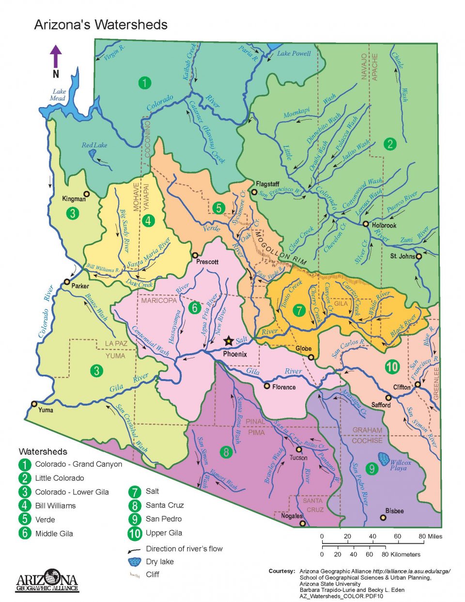
    Long ago, Arizona adopted the prior appropriation doctrine to govern surface water use. Based on the tenet of "first in time, first in right," the person who first puts the water to a beneficial use acquires a right senior to later water appropriators.[1]

    Before June 12, 1919, a person could acquire a surface water right simply by applying the water to a beneficial use and posting a notice of the appropriation where the water was diverted.[1]

    On June 12, 1919, the Arizona Surface Water Code, now known as the Public Water Code, was enacted. The law states that a person must obtain a permit and certificate to use surface water and that "beneficial use shall be the basis, measure, and limit to the use of water within the state."[1]

    Arizona Revised Statute § 45-151(A) defines beneficial uses as "domestic, municipal, irrigation, stock watering, water power, recreation, wildlife, including fish, nonrecoverable water storage pursuant to section 45-833.01 or mining uses..."[2]

    Arizona's protected surface waters include:

    How is surface water quality protected in Arizona?
    E. Jordan and Sky Island Alliance
    Apr. 13, 2023
    YouTube
    https://www.youtube.com/watch?v=20sfEqhGtSY
    Embedded video, no copy made
    Additional protected perennial or intermittent surface waters include:

    Sources:

    [1] Arizona Department of Water Resources. (2022). Surface water. https://new.azwater.gov/surface-water

    [2] Arizona Legislature. (n. d.). Arizona Revised Statute § 45-151. https://www.azleg.gov/ars/45/00151.htm

    [3] Arizona Legislature. (n. d.). Arizona Revised Statute § 49-221. https://www.azleg.gov/ars/49/00221.htm


    Water Quality

    The 1974 Safe Drinking Water Act (SDWA), amended in 1986 and 1996, authorizes the United States Environmental Protection Agency (EPA) to set national standards for drinking water to protect against both naturally-occurring and man-made contaminants. The EPA, states and water systems work together to make sure the standards are met.[1]

    Drinking water protection begins with an assessment of the quality of all public water sources and continues through regulations that govern water system design and construction. Drinking water quality is assured through scheduled tests for potential contaminants. Test results are reported to the ADEQ (Arizona Department of Environmental Quality) Water Quality Division (WQD) and a summary provided to customers annually.[2]

    2020 Arizona population by city
    2020 Arizona population by city
    D. Meeks
    Oct. 3, 2020
    Data source: World Population Review
    https://worldpopulationreview.com/states
    CC BY-SA 4.0
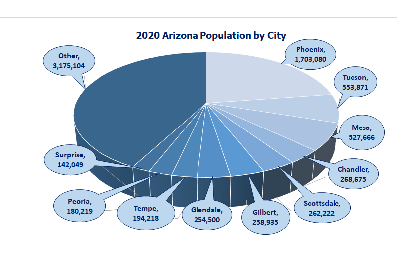
    The U.S. has some of the world's cleanest drinking water,[1] and the ADEQ WQD helps ensure that Arizona's water is safe and clean.[2] The ADEQ WQD protects public health and the environment by ensuring public and private drinking water is safe by:

    ADEQ also monitors the general health of Arizona's waters by:

    The WQD implements a number of Clean Water Act (CWA) programs including: Salt River Project (SRP) monitors the rivers, canals, and wells in its service area by regularly testing the water to identify pollution and water quality patterns. SRP collects canal samples monthly and well samples annually. The samples are tested in a state-certified SRP lab.[3]

    SRP utilizes computer modeling to track nitrateusually combined with sodium or potassium and used as a fertilizer levels. Nitrate is found naturally in lakes, rivers and well water, but high nitrate levels can be unsafe.[3]

    Central Arizona Project (CAP) has a monitoring program providing water users with real-time measurements and monthly and quarterly sample results.[4] CAP's Water Quality website also includes publicly-accessible annual reports listing detailed information on water samples, chemical components, and pollution.[5]

    Some cities, including Phoenix, issue their own water quality reports. Phoenix's reports are colorful, easy-to-read, and written in language that consumers can understand.[6]

    How many gallons in an acre-foot?
    Chapter 7.09 Hazardous Waste, 7.21 Liquid Waste, 7.29 Solid Waste, 7.31 Management of Used Oil, and 7.37 Water Potability of Title 7 of Pima County's Codes provide additional information on the Arizona laws that govern the mitigation and removal of potentially dangerous substances that can seep into Arizona's water.[7] Unlike several states Arizona does not require public notifications for sewer pollution discharges.[8]

    Sources:

    [1] Environmental Protection Agency. (Jun. 2004). Understanding the Safe Drinking Water Act. https://www.epa.gov/sites/production/files/2015-04/documents/epa816f04030.pdf

    [2] Arizona Department of Environmental Quality. (n. d.). Learn more about the Water Quality programs. https://www.azdeq.gov/wqd

    [3] Salt River Project. (2020). Keeping our water clean. https://www.srpnet.com/water/quality-monitoring.aspx

    [4] Central Arizona Project. (2020). Water quality. https://www.cap-az.com/departments/water-operations/water-quality

    [5] Central Arizona Project. (2018). Annual water quality report. https://www.cap-az.com/documents/water-operations/quality-reports/2018_Annual_Water_Quality_Report.pdf

    [6] City of Phoenix. (2019). Water quality report. https://www.phoenix.gov/waterservicessite/documents/wsdprimarywqr.pdf

    [7] American Legal Publishing Corporation. (n. d.). Pima County Codes Title 7 Environmental Quality. https://codelibrary.amlegal.com/codes/pimacounty/latest/pimacounty_az/0-0-0-1975

    Where does the Central Arizona Project end?
    [8] Chrisco, D. (Oct. 3, 2022). Which states require public notifications for sewer pollution discharges? Water Online. https://www.wateronline.com/doc/which-states-require-public-notifications-for-sewer-pollution-discharges-0001
    ?vm_tId=2496900&vm_nId=78916&user=651e1a62-117d-4912-b846-1b4d45e245a9&gdpr=0&vm_alias=Which%20States%20Require%20
    Public%20Notifications%20For%20Sewer%20Pollution%20Discharges%3F&utm_source=mkt_WOL&utm_medium=email&
    utm_campaign=WOL_02-07-2023
    &utm_term=651e1a62-117d-4912-b846-1b4d45e245a9&utm_content=Which%20States%20Require%20Public%20
    Notifications%20For%20Sewer%20Pollution%20Discharges%3F&mkt_tok=MDc1LU5WQy0wODYAAAGJypCm0IYN7r
    Ew9DJPjNUmf77rTRum6d-0Fgmm92MJlULWwi_ocgGpK2NJxACRybWV4DCNrDR0p8FHRonMihNBAA7T4I3ak1uLq7wVSrx1s6WQlg

    [9] State of Arizona. (Oct. 1, 2022). Title 18. Environmental quality Chapter 11. Department of Environmental Quality - Water quality standards. Arizona Administrative Code. https://apps.azsos.gov/public_services/Title_18/18-11.pdf


    One Water Brewing Showcase
    Scottsdale Water
    Jul. 15, 2020
    YouTube
    https://www.youtube.com/watch?v=gt5sldaElT0
    Embedded video, no copy made
     
    Innovation

    On January 1, 2018, the state of Arizona enacted Arizona Administrative Code, Title 18 Chapter 9 R18-9-E701 Recycled Water Individual Permit for an Advanced Reclaimed Water Treatment Facility,[1] allowing direct potable reuse (DPR). Before that date, advanced water treatment (AWT) water was not allowed in Arizona drinking water.[2]

    In November, 2019, Scottsdale Water and Scottsdale Arts held the One Water Brewing Showcase to introduce the public to the idea of recycled potable wastewater. Ten Scottsdale breweries participated.[3]

    Scottsdale was the third city in the U.S. to receive a permit for DPR and was the first in Arizona. The utility spent 18 months working with the Arizona Department of Environmental Quality (ADEQ) establishing the process to obtain this special permit.[3]

    The Advanced Water Treatment (AWT) Plant at the Scottsdale Water Campus has been using indirect potable reuse (IPR). The plant had been returning ultrapure water into the drinking water aquifera body of permeable rock which can contain or transmit groundwater for more than 20 years, recharging over 70 billion gallons into regional aquifers since 1988.[3]

    While AWT water is ultrapure and cleaner than bottled water, Scottsdale is not yet planning on including DPR in its water supply, will continue to rely on its diverse water sources, including IPR to recharge its aquifer for future use.[3]

    Other cities are pursuing DPR as a long-term water source. Scottsdale's permitting experience provides a model for obtaining an ADEQ DPR permit.[2]

    Beer Made from Recycled Water in Scottsdale
    AZFamily 3TV and CBS 5 News
    Sep. 17, 2019
    YouTube
    https://www.youtube.com/watch?v=jutZKaSNLfA
    Embedded video, no copy made
    Sources:

    [1] Arizona Administrative Code. (Sep. 30, 2019). Title 18 Chapter 9 R18-9-E701. Recycled water individual permit for an advanced reclaimed water treatment facility. https://apps.azsos.gov/public_services/title_18/18-09.pdf

    [2] Graf, C. (Mar. 30, 2022). Personal communication via Zoom.

    [3] Sherbert, N. (Oct. 29, 2019). City of Scottsdale. https://www.scottsdaleaz.gov/water/news/cheers-breweries-serving-craft-beer-from-recycled-water


    Lakes and Recreation

    Colorado River and Salt River dams and Arizona's natural canyons have created several large lakes and recreation areas homes to a large variety of birds and plants. Water depth also serves as an indicator of drought and environmental conditions.[1] When Lakes Mead and Powell are full, they can hold nearly four years of Colorado River water, but a drought that began in 2000 has caused significant drops in both lakes.[2]

    Lake Pleasant - A dual-purpose water supply for Arizona
    Central Arizona Project
    Jul. 17, 2023
    YouTube
    https://www.youtube.com/watch?v=IZRX1pJXmg0
    Embedded video, no copy made
    There are many small recreational lakes in Arizona. Most are located in national forests and provide fishing, camping, kayaking, swimming, boating and other recreational facilities.

    Alamo Lake is in the Bill Williams River Valley in eastern LaPaz and Mohave counties.

    Lake Mary, Ashurst Lake, Knoll Lake, Mormon Lake, Kinnikinick Lake, Marshall Lake and Long Lake are all located in Coconino National Forest in northern Arizona near Flagstaff.

    Apache-Sitgreaves National Forest is the home of Bear Lake, Black Canyon Lake, Carnero Lake, Chevelon Canyon Lake, Cresent Lake, Knoll Lake, Luna Lake, Rainbow Lake, River Reservoir, Willow Springs Lake and Woods Canyon Lake. The forest runs through Coconino, Navajo, Apache and Greenlee counties.

    Kaibab Lake is in Kaibab National Forest, adjacent to the northern and southern rims of the Grand Canyon.

    Becker Lake, Big Lake, Hawley Lake and Reservation Lake are in the White Mountains, and the last two of these lakes are within the boundary of the White Mountain Apache Indian Reservation, near the Arizona-New Mexico border.

    Goldwater Lake and Lynx Lake are in the Prescott National Forest, north of Prescott and west of Williams.

    Parker Canyon Lake, Patagonia Lake, Pena Blanca Lake, Riggs Flat Lake, Rose Canyon Lake and Roper Lake are in the Coronado National Forest. This forest covers parts Cochise, Graham, Santa Cruz, Pima and Pinal Counties, and is the forest best known to Tucsonans. It is home to a summer escape spot, Mt. Lemmon.

    Tempe Town Lake
    Tempe Town Lake
    Robertbody
    Dec. 26, 2008
    Wikipedia Tempe Lake
    https://en.wikipedia.org/
    wiki/Tempe_Town_Lake#/media/
    File:Tempe_Town_Lake_at_night.jpg
    CC BY-SA 3.0
    Martinez Lake is a small lake located in the southwestern corner Arizona, about 60 miles north of Yuma.

    Aguirre Lake, is located in Buenos Aires National Wildlife Refuge, and Arivaca Lake is located near the old Ruby Road, among grasslands surrounded by rock formations and mountain views.

    The state also has several munipal lakes. Tempe Town and Kiwanis Lakes, located in downtown Tempe, Watson Lake maintained by Prescott, Show Low Lake and Rainbow Lake shared by the towns of Pinetop and Lakeside in Navajo County, and Sahuarita Lake in southern Arizona.

    Sources:

    [1] Arizona State Climate Office. (n. d.). Arizona drought. https://azclimate.asu.edu/drought/

    [2] Glennon, R. (Jun. 26, 2019). John Wesley Powell, great explorer of the American West. University of Arizona College of Law. Scientific American. https://blogs.scientificamerican.com/observations/john-wesley-powell-great-explorer-of-the-american-west/

    [3] Roosevelt Lake Marina. (n. d.). Arizona's boating paradise Roosevelt Lake Marina. https://rlmaz.com/

    [4] Apache Lake Marina and Resort. (n. d.). Apache Lake. https://apachelake.com/

    [5] Saguaro Lake Marina. (n. d.). Saguaro Lake. https://www.saguarolakemarina.com/

    What doctrine provides for Tribal water access and use?
    [6] Arizona the Grand Canyon State. (2020). Canyon Lake. https://www.visitarizona.com/places/parks-monuments/canyon-lake/

    [7] Arizona's Best Kept Secret. (n. d.). Bartlett Lake. http://www.bartlettlake.com/

    [8] Waitingforrain. (Jul. 6, 2020). Horseshoe Lake AZ: Your guide to exploring a remote Phoenix Lake. Nightborn Travel. https://nightborntravel.com/horseshoe-lake-az/

    [9] USDA Forest Service. C.C. Cragin (Blue Ridge) Reservoir. https://www.fs.usda.gov/recarea/coconino/recarea/?recid=54898

    [10] Lake Powell Resorts and Marinas. (n. d.). Lake Powell. https://www.lakepowell.com/

    [11] National Park Service. (n. d.). Lake Mead National Recreation Area. https://www.nps.gov/lake/planyourvisit/lake-mead.htm

    What country has the largest hydropower station?
    [12] National Park Service. (2020). Lake Mohave. https://www.nps.gov/lake/learn/nature/overview-of-lake-mohave.htm

    [13] Arizona State Parks. (2020). Lake Havasu State Park. https://azstateparks.com/lake-havasu/

    [14] Maricopa County Parks and Recreation. (n. d.). Lake Pleasant Regional Park. https://www.maricopacountyparks.net/park-locator/lake-pleasant-regional-park/

    [15] Arizona The Grand Canyon State. (n. d.). Canyon Lake. https://www.visitarizona.com/places/parks-monuments/canyon-lake/

    [16] Arizona the Grand Canyon State. (2020). San Carlos Lake. https://www.visitarizona.com/places/parks-monuments/san-carlos-lake/

    [17] Arizona State Parks. (2020). Lyman Lake State Park. https://azstateparks.com/lyman-lake/explore/maps


    Conservation[*]

    Average daily water use per individual in the U.S.?

    The oldest reclaimed non-potable water system is in Grand Canyon Village, Arizona, which has been using reclaimed water for nonpotable uses since 1926.[13]

    Flagstaff has been using reclaimed water for irrigation since 1965 and operates two water reclamation plants with a combined capacity of 10 million gallons per day, providing high-quality Class A+ reclaimed water. This water is transported to users in a separate distribution system and accounts for about 20% of the city's water use.[21]

    In 1973 the Arizona Municipal Water Users Association (AMWUA) negotiated an agreement among five member cities and Arizona Public Service to provide treated wastewater to the Palo Verde Nuclear Generating Station. It is the only nuclear power facility in the U.S. cooled by recycled water.[14]

    Central Arizona Project
    2023 Colorado River shortage update
    Aug. 30, 2023
    YouTube
    https://www.youtube.com/watch?v=FQf1vEzbqDg
    Embedded video, no copy made
    In 1999 Mesa, Scottsdale and Phoenix started the Water - Use It Wisely campaign, based on the "Don't tell us to save water. Show us how" concept. The campaign developed a 10-part video series on xeriscaping and tips and guides on water conservation.[17]

    The Water - Use It Wisely partnership now includes:

    In 2010 the Governor's Blue Ribbon Panel on Water Sustainability recommended conservation and recycling strategies.[15]

    In 2012 the Steering Committee for Arizona Potable Reuse (SCAPR) was formed "To guide Arizona water interests in identifying and mitigating impediments to potable reuse (real or imagined) within industry standards of practice."[15]

    What are the 5 classes of water quality in Arizona?
    SCAPR organized advisory panels to explore advanced treatment technologies for contaminant removal and public acceptance of potable reuse. Expert input on communication strategies, best practices, timelines, and public relations campaigns were collected and published.[15]

    Arizona's Next Century: A Strategic Vision for Water Supply Sustainability stated that direct potable reuse (DPR)involves the treatment and distribution of water without an environmental buffer exploration was necessary due to increasing water demand. The report established a 10-year plan, including a review of legal and institutional barriers to DPR. The report stated that reclaimed water could offset projected state water imbalances by about 50%.[16]

    Arizona has a good start on establishing DPR regulations. Arizona Department of Environmental Quality (ADEQ) set stringent treatment standards for new and expanding wastewater treatment plants that require nitrogen reduction to below drinking water limits and removal of fecal coliform bacteria, an indicator of pathogensa virus, bacteria or fungus that causes disease to non-detectable levels. Water quality standards are designated in rule for five reclaimed water quality classes, based on human health protection and an effective permit system expanded safe reclaimed water use.[16]

    AMWUA cities now recycle more than 95% of their treated wastewater to sustain fishing lakes, create wetlands, irrigate fields and parks and store underground for future use.[14]

    What is the largest river that passes through Tucson?
    ADEQ, Arizona Department of Water Resources (ADWR), AMWUA, Central Arizona Project (CAP) and Salt River Project (SRP) issued a joint statement in March 2020, assuring Arizonans that

    We have planned and invested in robust and resilient water supplies, infrastructure and processes so that your local water provider can deliver you water every day of every year. Through our collaborative efforts, we can bring water from Arizona's mountains and the Colorado River, and manage our groundwater.

    We are each taking extra precautions by implementing resiliency plans that have been developed for times like these to better ensure essential operations continue without interruption and we can fully support local water providers - all of which could not be achieved without the dedicated efforts of all of our employees.

    Together we remain committed to safeguarding our water supplies so they remain secure not just for today, but for the future.[1]

    Arizona water uses
    Arizona water uses
    D. Meeks
    Oct. 10, 2020
    Data source: Arizona Department of Water Quality
    2020.
    Arizona Water Facts.
    http://www.arizonawaterfacts.com/water-your-facts
    CC BY-SA 4.0
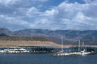
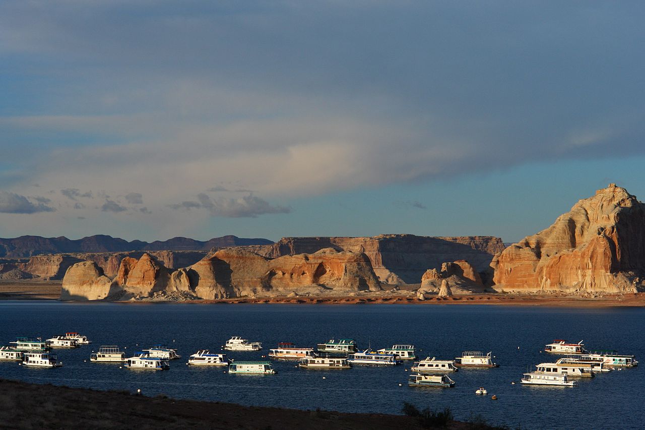
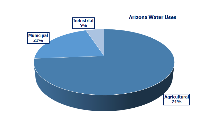
    Arizona has undertaken extensive water conservation efforts.

    Municipal:

    Industrial: Agricultural:
    Arizona irrigation districts
    Arizona irrigation districts
    Arizona Department of Water Resources
    https://new.azwater.gov/sites/default/files/irrigationdistricts.pdf
    Used with written permission of ADWR
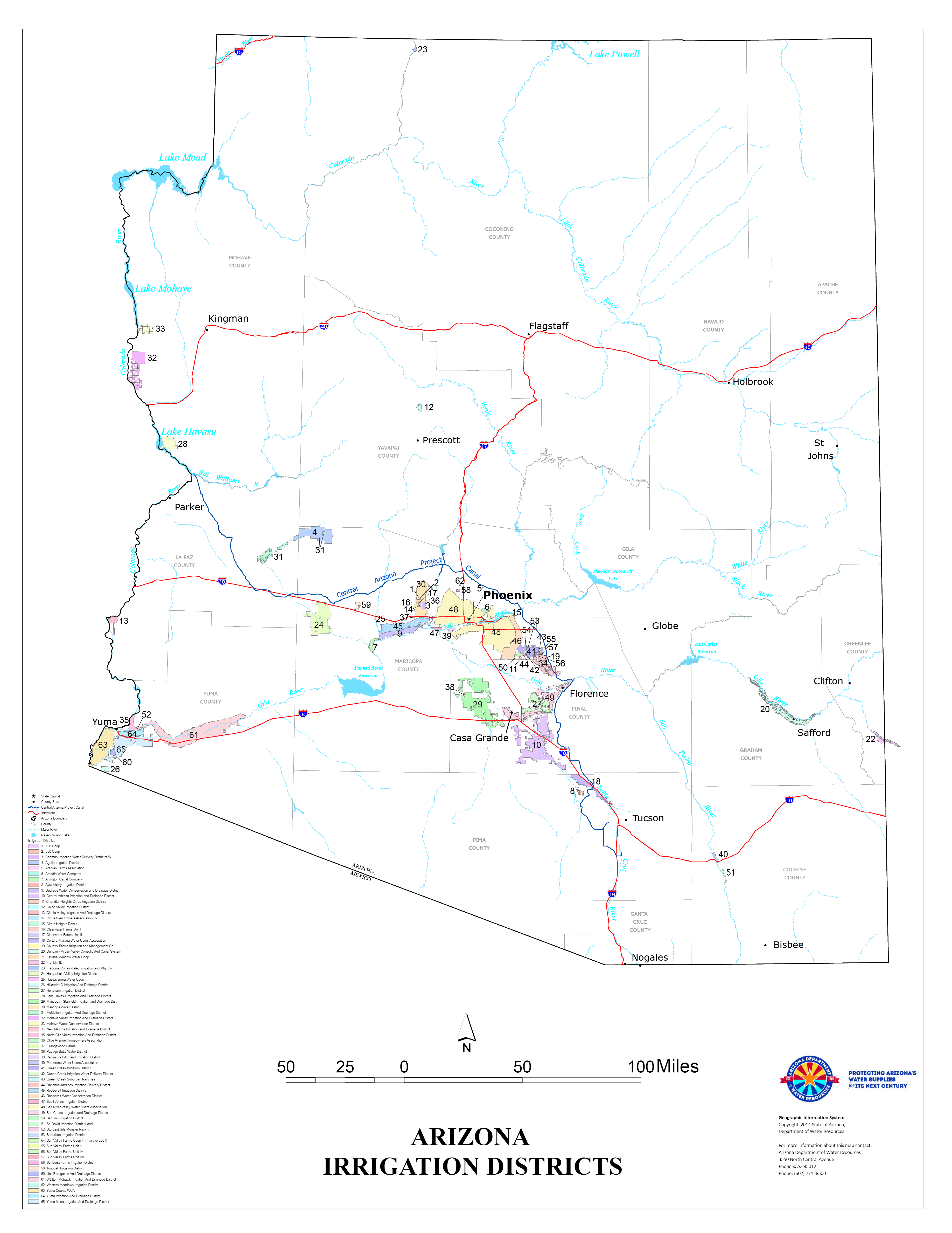
    A recent SRP, U.S. Bureau of Reclamation and Arizona State University report found that SRP reservoirs will provide a reliable water supply even under sever climate change because SRP's water supplies are less sensitive to climate change than other western U.S. regions.[3] As of 2020, the state stored nearly 3 trillion gallons of water, enough to support the city of Phoenix for the next 30 years.[2]

    Runoff within the Salt River system occurs earlier in the season than in other parts of the country. This results in lower water loss and less evaporation than other parts of the country.[3]

    CAP has made several water conservation suggestions to consumers:

    CAP also provides additional suggestions on reducing, reusing, recycling, conservation and natural resource protection that work hand-in-hand with water conservation efforts.[5]

    In 2018 ADWR published a report that listed Arizona's municipal water providers designated as having an assured or adequate water supply.[6]

    Reclaimed water has many applications.

    Urban:

    Arizona golf courses using reclaimed water
    Google Maps
    used per Google Maps/Google Earth Additional Terms of Service
    https://www.google.com/intl/en_us/help/terms_maps/
    Agricultural: Recreational:
    What is the name of the cave system in the Whetstone Mountains?
    Environmental: Potable:

    1960 Water Conservation Stamp
    1960 Water Conservation Stamp
    Bureau of Engraving and
    Printing U.S. Post Office
    Feb. 11, 2008
    https://en.wikipedia.org/
    wiki/Water_conservation#/media/
    File:Water-conservation-stamp-1960.jpg
    public domain
    ADWR's Assured and Adequate Water Supply programs address limited groundwater supplies. Both programs evaluate the availability of a 100-year water supply considering demand and growth.[9]

    The Assured Water Supply Program operates within Active Management Areas (AMAs). Its purpose is to maintain economic health by preserving groundwater resources and promoting long-term water planning.[9]

    The Adequate Water Supply Program operates outside of the AMAs to ensure water inadequacy and supply limitations disclosed. Water supply adequacy must be demonstrated prior to plat approval and issuance of a public report.[9]

    The publicly available ADWR Water Management Assistance Program (WMAP) Dashboard provides financial and technical resources in development and implementation of conservation programs, facilitation and augmentation of renewable water supply utilization, information on hydrologic conditions and water availability in an AMA.[12]

    ADWR also provides additional conservation-related resources for the public, water providers and agricultural, commercial, industrial and institutional water users.[8]

    CAP and CAGRD are EPA WaterSense partners. They recently started a program that invites homebuilders to apply for rebates of up to $1,000 for new houses earning Water Sense 2.0 certification, the first in this region.[20]

    WaterSense-labeled homes use 30% less water than typical new construction, meaning that less groundwater is used by CAGRD members in this program.[20]

    Homebuilders get help with WaterSense certification costs. CAGRD collects $2 per lot from developer enrollment fees and $2 for every acre-foot of excess groundwater reported annually by its members to fund conservation efforts including this water-efficient construction incentive program.[20]

    KB Home was the first recipient for 43 homes located in the Entrada del Rio development in Sahuarita and the Rocking K community in southeast Tucson. These homes are served by the Spanish Trail Water Company and Sahuarita Water Company both CAGRD Member Service areas.[20]

    Many Arizona cities, including Avondale, Chandler, Glendale, Mesa, Paradise Valley, Peoria, Phoenix, Scottsdale, Surprise, Superior, Tempe and Tucson, host xeriscapinglandscaping requiring little or no irrigation demonstration gardens where visitors can learn how to install and maintain low-water use desert gardens.[11]
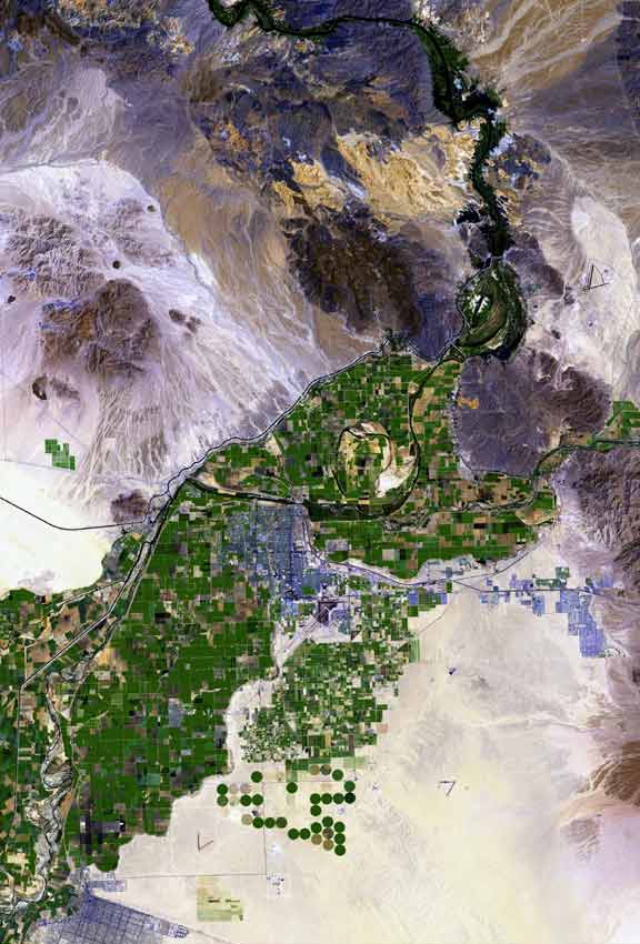
    Santa Cruz River cleans up 27-hundred pounds of trash
    News 4 Tucson
    May 20, 2023
    YouTube
    https://www.youtube.com/watch?v=3AV98cGMLZY
    Embedded video, no copy made
    The Sonoran Institute is focused on shaping the west with flourishing landscapes, abundant natural resources and vibrant communities. Many of the non-profit organization's efforts involve river and estuary restoration, protection and preservation.[18] Its partners include federal, state and local organizations, institutes, utilities and water advocates.[19]

    Sources:

    [1] Salt River Project. (Mar. 27, 2020). Arizona's water supplies remain secure and resilient. https://media.srpnet.com/arizonas-water-supplies-remain-secure-and-resilient/

    [2] Arizona Department of Water Resources. (2020). Arizona water facts. http://www.arizonawaterfacts.com/water-your-facts

    [3] Salt River Project Watershed Connection. (Sep. 2, 2020). Climate change resilience. https://www.watershedconnection.com/projects/climate-change-resilience.aspx

    [4] Central Arizona Project. (n. d.). WaterSense partnership. https://www.cap-az.com/sustainability/watersense-partnership

    Lower Antelope Canyon is also known as?
    [5] Central Arizona Project. (n. d.). Sustainability fact sheet. https://library.cap-az.com/documents/factsheets/CAP-FactSheet-Sustainability.pdf

    [6] Arizona Department of Water Resources. (Jan. 4, 2018). List of municipal water providers designated as having an assured or adequate water supply. https://new.azwater.gov/sites/default/files/media/List_of_Designated_Providers_1-4-2018_1.pdf

    [7] USGS. (Jun. 8, 2018). Reclaimed wastewater. https://www.usgs.gov/special-topics/water-science-school/science/reclaimed-wastewater

    [8] Arizona Department of Water Resources. (2022). Conservation. https://new.azwater.gov/conservation/public-resources

    [9] Arizona Department of Water Resources. (2022). Assured and adequate water supply. https://new.azwater.gov/aaws

    Where is the Pinacate located?
    [10] Syed, Z. (Nov. 13, 2022). To save water, Arizona farmers are growing guayule for sustainable tires. PopSci. https://www.popsci.com/environment/guayule-sustainable-farmers-water/#:~:text=To%20save%20water%2C%20Arizona%20farmers,a%20popular%20drought-tolerant%20crop.&text=Most%20farmers%20in%20Pinal%20County,water%20cuts%20were%20coming%20eventually.

    [11] Water Use It Wisely. (2022). Xeriscaping inspiration. https://wateruseitwisely.com/saving-water-outdoors/our-top-landscape-ideas/demo-gardens/

    [12] Arizona Department of Water Resources. (n. d.). Water management assistance program. Active Management Areas. https://new.azwater.gov/ama/wmap

    [13] National Research Council. (2012). Understanding water reuse: Potential for expanding the nation's water supply through reuse of municipal wastewater. National Academies Press. https://doi.org/10.17226/13514

    [14] Tenney, W. (Sep. 11, 2017). AZ to permit purified wastewater as drinking water source. AMWUA. https://www.amwua.org/blog/arizona-to-permit-purified-wastewater-as-drinking-water-source#:~:text=Arizona%20is%20among%20a%20half,in%20treating%20and%20recycling%20wastewater.

    [15] Thomure, T. (n. d.). Potable reuse - A state of the industry update. WateReuse Association. https://watereuse.org/wp-content/uploads/2015/09/Papers-Arizona-State-of-the-Industry-Potable-Reuse.pdf

    What court case affirmed federal control over Tribal water rights?
    [16] Arizona Department of Water Resources. (Jan. 2014). Arizona's next century: A strategic vision for water supply sustainability. https://new.azwater.gov/sites/default/files/media/ArizonaStrategicVisionfor
    WaterResourcesSustainability_May2014%20%2817%29.pdf

    [17] Arizona Department of Water Resources. (Jan. 25, 2018). For nearly two decades, "Water - Use it wisely" campaign has shown the way. https://new.azwater.gov/news/articles/2018-25-01
    [18] Sonoran Institute. (2023). Our focus. https://sonoraninstitute.org/focus/

    [19] Sonoran Institute. (2023). Our partners. https://sonoraninstitute.org/our-story/partners/

    [20] Person, D. (Jul. 24, 2023). CAGRD incentivizes water-efficient construction leading to less groundwater use. Know Your Water News. Central Arizona Project. https://knowyourwaternews.com/cagrd-incentivizes-water-efficient-construction-leading-to-less-groundwater-use/

    [21] City of Flagstaff. (n. d.). Reclaimed water. https://www.flagstaff.az.gov/21/Reclaimed-Water
     
    [*] Some of the Conservation section materials posted in this site originally included in A survey of regulatory, technical, and public outreach challenges and opportunities for direct potable reuse with an emphasis on Tucson and Pima County, Arizona by this author


    Legal History[*]

    The Colorado River is managed and operated under federal laws, court decisions, state and international agreements and regulatory guidelines. These consitute the "Law of the River."[1] There are also many minutesan official record of what was said and done in a meeting between the U.S. and Mexico.

    Colorado River, Arizona Water and National Acts and Agreements Related to Arizona Water Use[1]
    year↕ title↕ ✔ purpose location↕ subject↕
    1849 Swamp and Overflowed Land Act
  • entrusted certain wetlands to the federal states for the purpose of constructing necessary levees and drains to reclaim the swamp and overflowed land
  • explicitly provides that federal land can be transferred only when the majority of a parcel of land was wet and unfit for cultivation[81]
  • U.S. land reclamation
    1877 Desert Land Act
  • enabled citizens to purchase up to 640 acres of land in California, Oregon and Nevada, and the territories of Washington, Idaho, Montana, Utah, Wyoming Arizona, New Mexico and Dakota, with water rights limited to certain appropriations for irrigation and reclamation
  • with all surplus water, lakes, rivers and other water sources reserved for public use[2]
  • western U.S. land purchase
    1887 Wright Act
  • allowed farming regions to form and bond irrigation districts which allowed small farm owners to band together, pool resources, and get water to where it was needed
  • enabled the diverting of waters from the Merced, San Joaquin and Kings rivers in California's Central Valley[82]
  • California water diversion
    1894 Carey Land Act
  • provided for the transfer to western U.S. states desert lands on the condition that they be irrigated
  • enabled settlers to buy up to 160 acres of the land at 50 cents per acre plus the cost of water rights, but did not facilitate reclamation and settlement effort[3]
  • western U.S. land irrigation
    1902 National Reclamation Act
  • established the U.S. Reclamation Service within the USGS, which studied potential water development projects in each western state with federal lands
  • revenue from sale of federal lands was the initial source of the program's funding[4]
  • western U.S. water development projects
    1907 Kansas v. Colorado
  • Kansas claimed that Colorado was using water to which it was not entitled
  • the Court ruled that Colorado was not affecting Kansas' water use
  • Colorado was benefiting from water use and was entitled to continue using it[68]
  • Colorado and Kansas water claims
    1908 Winters v. United States - 207 U.S. 564, 28 S. Ct. 207 (1908)
  • the decree enjoining the companies from utilizing river waters intended for an Indian Reservation was affirmed
  • the Court held that while the U.S. could itself abrogate rights granted to the Indians under a treaty with them, it alone had this power, and unless such rights were abrogated by the U.S. by subsequent legislation it was well settled that all rights acquired by the Indians under the treaty were to be fully protected against invasion by other parties[76]
  • U.S. Tribal water rights
    1909 Enlarged Homestead Act
  • provided 320 acres of non-mineral, non-irrigable, non-timber land, designated by the Secretary of the Interior, to settlers in Colorado, Montana, Nevada, Oregon, Utah, Washington, and Wyoming, and the Territories of Arizona and New Mexico[5]
  • western U.S. land purchase
    1916 Stock Raising Homestead Act
  • allowed ranchers to privatize lands they considered valueless except for grazing livestock and forage growth
  • homesteaders obtained land surface ownership, but the federal government retained mineral rights
  • over 70 million acres of public lands were privatized under this act, including 2,986,746 acres in Arizona[6]
  • western U.S. land privatization
    1920 Federal Power Act
  • provided a clear process for attaining federal authority on hydropower development by creating the Federal Power Commission (FPC)[70]
  • U.S. hydropower
    1922 Colorado River Compact
  • provided for the equitable division and apportionment of the use of the waters of the Colorado River System
  • to establish the relative importance of different beneficial uses of water, to promote interstate comity
  • to remove causes of present and future controversies; and to secure the expeditious agricultural and industrial development of the Colorado River Basin, the storage of its waters, and the protection of life and property from floods[45]
  • Colorado River Basin water division
    1922 Wyoming v. Colorado
  • Wyoming wanted to prevent Colorado from using water from the Laramie River, whose source is in Wyoming
  • the Court ruled that non-navigable water from a stream in an Upper Colorado River Basin state that flow into a Lower Colorado River Basin state can't be disposed of by the Upper Colorado Basin State to the detriment of the Lower Colorado Basin state[69]
  • Colorado and Wyoming water rights
    1928 Boulder Canyon Project Act
  • provided for the construction of works for the protection and development of the Colorado River basin, for the approval of the Colorado River Compact, and for other purposes[46]
  • Colorado River Basin water protection
    1929 California Limitation Act
  • California agreed not to use more than four million four hundred thousand acre-feet of the waters apportioned to the lower basin states and to comply with the Boulder Canyon Project Act[80]
  • Colorado River Basin water rights
    1931 California Seven Party Agreement
  • helped settle long-standing conflict between California agricultural and municipal interests over Colorado River water priorities with the Palo Verde Irrigation District, Yuma Project, Imperial Irrigation District, Coachella Valley Irrigation District, Metropolitan Water District and the City and County of San Diego[41]
  • Arizona and California water division
    1938 Agricultural Adjustment Act
  • offered farmers subsidies in exchange for limiting production of certain crops so that crop prices could increase[83]
  • U.S. water use
    1944 Mexican Water Treaty, Utilization of Waters of the Colorado and Tijuana Rivers and of the Rio Grande
  • settled disputes between the U.S. and Mexico related to the Rio Grande and the Colorado River and established the International Boundary and Water Commission[47]
  • Colorado River and Rio Grande international boundary
    1948 Upper Colorado River Basin Compact
  • divided the water apportioned to the Upper Basin by the Colorado River Compact between the five states having territory in the Upper Basin
  • Arizona was allocated 50,000 acre-feet per annum with the remainder of the Upper Basin entitlement divided with the following percentages: Colorado, 51.75, New Mexico, 11.25, Utah, 23.00 and Wyoming, 14.00[48]
  • Upper Colorado River Basin states water division
    1955 Arizona Revised Statutes Title 45 - Water
  • defined administration and general provisions, groundwater code, underground water storage, savings and replenishment, water exchanges, dams and reservoirs, interstate streams, flood control, weather control and cloud modification, state water and power plan, county water augmentation authority, Arizona water protection fund, county water authority, Arizona water banking authority, Gila River Indian Community water settlement program and Tohono O'odham water settlement program
  • has been modified by the Arizona State Legislature[72]
  • Arizona water regulations
    1956 Colorado River Storage Project Act
  • authorized construction of the Colorado River Storage Project
  • allowing for comprehensive development of the water resources of the Upper Basin states by providing for long-term regulatory storage of water for purposes including regulating the Colorado River
  • storing water for beneficial use
  • allowing Upper Basin States to utilize their Colorado River Compact apportionments
  • providing for the reclamation of arid lands and control of floods and generation of hydroelectric power[49]
  • Upper Colorado River Basin states water storage
    1964 Minute 217 Clearing of the Colorado River Channel Downstream from Morelos Dam
  • authorized the clearing of 40 miles below Morelos Dam to be paid for by the US[14]
  • Arizona, California and Mexico river clearing
    1964 Arizona v. California U.S. Supreme Court Decree
  • reaffirmed the apportionment of the first 7,500,000 acre-feet per annum of Colorado River mainstream water available to the three Lower Basin States: Arizona, 2,800,000, California, 4,400,000, and Nevada, 300,000
  • any excess above 7,500,000 acre-feet was apportioned 50 percent to California and 50 percent to Arizona, except that Nevada was given the right to contract for 4 percent of the excess, which would come out of Arizona's share,[50]
  • longest case in U.S. Supreme Court history, filed in 1952, ruling was announced June 3, 1963
  • trial lasted more than two years and included more than 340 witnesses and thousands of exhibits
  • a little more than a year into the trial, attorney Mark Wilmer shocked the Court by reframing Arizona's legal strategy by arguing that Arizona's right to Colorado River water was based on rights given by the Boulder Canyon Project Act of 1928 which authorized Hoover Dam and All American Canal construction[61]
  • Lower Colorado River Basin states water division
    1965 Federal Water Project Recreation Act
  • in investigating and planning any federal navigation, flood control, reclamation, hydroelectric, or multiple-purpose water resource project, full consideration would be required for outdoor recreation and for fish and wildlife enhancement[86]
  • U.S. environmental protection
    1966 Hurley v. Abbott, 259 F. Supp. 669 (D. Ariz. 1966)
  • the Court held that it was without jurisdiction to enlarge the Kent Decree as requested by petitioner without joinder of all those interested parties in the Verde River watershed whose rights of appropriation were left unsettled by the original decree[74]
  • Verde River water appropriation
    1968 Colorado River Basin Project Act
  • authorized the CAP and other water development projects in the Upper Basin
  • directed the Secretary to prepare long-range water resources studies directed toward the augmentation of the Colorado River, to prepare criteria for the coordinated long-range operation of the Colorado River reservoirs, and to undertake programs for water salvage and groundwater recovery along and adjacent to the mainstream of the Colorado River
  • declared that the satisfaction of the requirements of the Mexican Water Treaty from the Colorado River constituted a national obligation, of particular importance to Arizona because of the shortage provision
  • directed the Secretary of the Interior to propose criteria for the coordinated long-range operation of federal reservoirs in the Colorado River Basin[51]
  • Colorado River Basin water development projects
    1968 Wild & Scenic Rivers Act
  • implemented a national wild and scenic rivers system and its initial components
  • prescribed methods allowing additional components to be added to the system[67]
  • U.S. environmental protection
    1970 Coordinated Long-Range Operation of Colorado River Reservoirs
  • issued to control coordinated long-range operation of the storage reservoirs in the Colorado River Basin constructed under the authority of the Colorado River Storage Project Act and the Boulder Canyon Project Act
  • will be administered consistent with applicable federal laws, the Mexican Water Treaty, interstate compacts and decrees relating to the use of the waters of the Colorado River[12]
  • Colorado River Basin water storage
    1972 Clean Water Act
  • established the structure for regulating discharges of pollutants into U.S. waters and regulated quality standards for surface waters
  • established EPA pollution control programs such as setting wastewater standards for industry and national water quality criteria recommendations for pollutants in surface waters[7]
  • U.S. pollution control
    1972 United States v. Gila Valley Irrigation District, 454 F. 2d 219 - Court of Appeals, 9th Circuit 1972
  • The water commissioner could divert water to Upper Valleys Users but that water was chargeable against the existing 120,000 acre foot limit[75]
  • Gila River water appropriation
    1972 Minute 240 Emergencies of Colorado River Waters for Use in Tijuana
  • stipulated that the US would undertake negotiations with the Metropolitan Water District of Southern California, the San Diego Water Authority, the City of San Diego and the Otay Municipal Water District to provide emergency water to Mexico at Tijuana[16]
  • California and Mexico water delivery to Mexico
    1972 Minute 241 Recommendation to Improve Immediately the Quality of Colorado River Waters Going to Mexico
  • agreement that the US would take steps to improve the quality of Colorado River water flowing into Mexico, continue to operate the Wellton-Mohawk District's drainage water conveyance channel, and continue to supply 118,000 acre-feet of water[15]
  • Arizona, California and Mexico water delivery to Mexico
    1973 Minute 242 Permanent and Definite Solution to the International Problem of the Salinity of the Colorado River
  • the U.S. adopted measures to assure that not earlier than January 1, 1974 and no later than July 1, 1974
  • the approximately 1,360,000 acre-feet of water delivered to Mexico upstream of the Morelos Dam, would have an annual average salinity of no more than 115 parts per million, plus or minus 30 parts per million over the average salinity of Colorado River waters arriving at the Imperial Dam[31]
  • Arizona, California and Mexico water salinity
    1973 Minute 243 An Amendment to Minute 240 Relating to Emergency Deliveries of Colorado River Water Use in Tijuana
  • Commission approved Mexico's request for deliveries of Colorado River water at a rate of at least 900 cubic feet per second[17]
  • Colorado River Basin water delivery to Mexico
    1974 Colorado River Basin Salinity Control Act
  • provided the means to comply with the U.S. obligations to Mexico under Minute No. 242
  • included a brine discharge canal and a desalination plant for the conveyance and treatment of Wellton Mohawk Irrigation and Drainage District drainage water enabling the U.S. to deliver water to Mexico having an average salinity of 115 parts per million over Colorado River salinity
  • authorized construction of four salinity control units and the expedited planning of twelve other salinity control projects above Imperial Dam as part of the basin-wide salinity control plan[52]
  • California and Mexico water delivery to Mexico
    1974 Safe Drinking Water Act
  • protects public health by regulating the nation's public drinking water supply[8]
  • U.S. drinking water safety
    1974 Minute 245 Additions and Modifications to Minute 240
  • negotiated energy charges between the US and Mexico for emergency water supply provided to Mexico[18]
  • U.S. water delivery to Mexico
    1975 Minute 248 Recommendation for Extension of the Wellton-Mohawk Bypass Drain in Mexican Territory
  • required Mexico to submit a plan for the construction for the extension of the concrete-lined Wellton-Mohawk bypass drain[19]
  • Arizona, California and Mexico water delivery to Mexico
    1976 Minute 252 An Amendment to Minutes Nos. 240 and 245, Relating to Emergency Deliveries of Colorado River Waters for Use in Tijuana
  • established that Mexico agreed to pay, beginning October 1976, for additional costs of treatment in the US of the portion of Mexico's Colorado River Treaty waters delivered through facilities in the US[20]
  • Colorado River Basin water delivery to Mexico
    1976 Minute 253 Maps of the International Boundary in the Rio Grande and in the Colorado River
  • confirmed that engineers appropriately established the international boundary on the Rio Grande and Colorado River maps[21]
  • Arizona, Texas and Mexico international boundaries
    1977 Minute 256 Extension of Minutes Nos. 240, 243, 245 and 252, Regarding Emergency Deliveries of Colorado River Waters for Use in Tijuana
  • stipulated that the emergency deliveries by the US to Mexico part of the Colorado River water allotted to Mexico by the 1944 Treaty be extended to August 14, 1978[22]
  • Colorado River Basin water delivery to Mexico
    1978 Reclamation Safety of Dams Act
  • authorized the Secretary of the Interior to construct, restore, operate, and maintain new or modified features at existing Federal reclamation dams for safety of dams purposes[53]
  • U.S. water reclamation
    1978 Minute 259 Extension of the Effect of Minute No. 256, Relating to the Emergency Deliveries of Colorado River Water for use in Tijuana
  • the effect of Minute 256 was extended to Aug. 14, 1979[23]
  • Colorado River Basin water delivery to Mexico
    1979 Minute 260 Extension of the effect of Minute No. 259, relating to the emergency deliveries of Colorado River water for use in Tijuana
  • water deliveries to Mexico were restarted and Mexico reestablished its Irrevocable Letter of Credit for $4,000[24]
  • Colorado River Basin water delivery to Mexico
    1980 Groundwater Management Act
  • established a groundwater rights and permits program, rules prohibiting irrigation of new agricultural lands in AMAs
  • prepared five water management plans for each AMA to create comprehensive conservation targets and water management criteria
  • required developers to submit 100-year water assurance plans, required metering for water pumped from large wells
  • created a program for annual water withdrawal and use reporting, and instituted penalties for non-compliance[54]
  • Arizona groundwater
    1980 Minute 263 Extension of the Effect of Minute No. 260, Relating to the Emergency Deliveries of Colorado River Water for Use in Tijuana
  • Mexico was required to provide three days notice for suspension and resumption of water deliveries and reestablish its Irrevocable Letter of Credit for $500,000[25]
  • Colorado River Basin water delivery to Mexico
    1980 Comprehensive Environmental Response, Compensation, and Liability Act (CERCLA)
  • created a tax on the chemical and petroleum industries
  • provided broad federal authority to respond directly to releases of hazardous substances endangering public health or the environment
  • established prohibitions and requirements concerning hazardous waste sites
  • provided for liability of persons responsible for releases of hazardous waste at these sites
  • established a trust fund for cleanup costs when no responsible party could be identified[64]
  • U.S. environmental protection
    1981 Minute 266 Extension of the Effect of Minute No. 263, Relating to the Emergency Deliveries of Colorado River Water for Use in Tijuana
  • Minute 263 was extended to August 14, 1982 and Mexico reestablished its Irrevocable Letter of Credit for $500,000[26]
  • Colorado River Basin water delivery to Mexico
    1982 Minute 267 Extension of the Effect of Minute No. 266, Relating to the Emergency Deliveries of Colorado River Water for Use in Tijuana
  • Minute 266 was extended to August 14, 1983[27]
  • Colorado River Basin water delivery to Mexico
    1982 Minute 268 Modification to Minute No. 253 Maps of the International Boundary in the Rio Grande and in the Colorado River
  • the commissioners reviewed maps, concluding that they conformed to the 1970 Boundary Treaty and and Mexico reestablished its Irrevocable Letter of Credit for $500,000[28]
  • Arizona, Texas and Mexico international boundaries
    1986 Safe Drinking Water Act Amendments of 1986
  • directed the EPA administrator to publish maximum contaminant level goals and promulgate national primary drinking water regulations[63]
  • U.S. drinking water safety
    1986 Arizona Revised Statutes Title 49 - The environment
  • defined general provisions, water quality control, air quality, solid waste management, hazardous waste disposal, underground storage tank regulation, light pollution, water infrastructure finance program, environmental audit privilege and natural gas storage facilities
  • has been modified by the Arizona State Legislature[73]
  • Arizona water regulations
    1988 Salt River Pima-Maricopa Indian Community Water Rights Settlement Agreement
  • resolved conflicts among the federal government, the Salt River Pima-Maricopa Indian Community, the Salt River Project Agricultural Improvement and Power District, the Salt River Valley Water Users Association, the Roosevelt Water Conservation District, the Roosevelt Irrigation District; the cities of Chandler, Glendale, Mesa, Phoenix, Scottsdale, Tempe and Gilbert and the Central Arizona Water Conservation District[9]
  • Arizona Salt River Project
    1990 Minute 280 Disposal of Equipment Installed at the Expense of Mexico in United States Territory to Enable Emergency deliveries of Colorado River Waters for Use in Tijuana, Baja California
  • approved the sale of equipment by Comision Estatal de Servicios Publicos de Tijuana-Tecate to the Texas Diesel Parts Supply Company for $39,500[29]
  • Colorado River Basin water delivery to Mexico
    1991 Minute 284 Rehabilitation of the Wellton-Mohawk Bypass Drain in Mexican Territory
  • the Government of Mexico, at U.S. Government expense, will carry out the rehabilitation of the Wellton-Mohawk Bypass Drain Extension in Mexico according to the approved work schedule and in accordance with laws in force in Mexico[32]
  • Arizona, California and Mexico water delivery to Mexico
    1992 Grand Canyon Protection Act
  • directed the Secretary of the Interior to manage and protect the Glen Canyon Dam against adverse impacts and to and improve the values for which Grand Canyon National Park and Glen Canyon National Recreation Area were established[55]
  • Arizona Glen Canyon Dam
    1992 Minute 287 Emergency Deliveries of Colorado River Waters for Use in Tijuana, Baja California
  • the US agreed to deliver between 120 and 160 acre-feet of water to Mexico[33]
  • California and Mexico water delivery to Mexico
    1994 Minute 291 mprovements to the Conveying Capacity of the International Boundary Segment of the Colorado River
  • the U.S. and Mexico agreed to remove sediments built up around the Morelos Dam[34]
  • Arizona, Colorado and Mexico water delivery to Mexico
    1996 Safe Drinking Water Act Amendments of 1996
  • defined community water system as a public water system that serves at least 15 service connections for the purpose of human consumption[62]
  • U.S. drinking water safety
    1999 Minute 301 Joint Colorado River Water Conveyance Planning Level Study For the San Diego, California - Tijuana, Baja California Region w/ Joint Report
  • recommended that the Commission undertake an international coordinating role to facilitate a study by the San Diego County Water Authority and Mexican authorities on Colorado water supply to San Diego[35]
  • California and Mexico water delivery to Mexico
    2000 Minute 306 Conceptual Framework for U.S. - Mx Studies for Future Recommendations Concerning the Riparian and Estuarine Ecology of the Limitrophe Section of the Colorado River and its Associated Delta
  • the Commission established a framework for the protection of riparian and estuarine Colorado River in its limitrophe sections and associated delta[36]
  • Colorado River Basin water delivery to Mexico
    2000 Executive Order 13175 Consultation and coordination with Indian Tribal governments
  • directed government agencies to respect Indian tribal self-government and sovereignty, honor tribal treaty and other rights, and strive to meet the responsibilities that arise from the unique legal relationship between the Federal Government and Indian tribal governments[87]
  • U.S. Tribal water rights
    2003 Minute 310 Emergency Delivery of Colorado River Water for use in Tijuana, Baja California w/ Joint Report
  • the Commission approved emergency delivery of water to Tijuana from the Colorado River[37]
  • California and Mexico water delivery to Mexico
    2004 Arizona Water Settlements Act
  • provided adjustments to CAP allocations, settled litigation between the U.S. and Central Arizona Water Conservancy District concerning payments
  • authorized the Gila River Indian Community Water Rights Settlement, amended and reauthorized the Southern Arizona Water Rights Settlement Act of 1982
  • provided funding for the Gila River Indian Community and Tohono O'odham Nation to rehabilitate and expand water infrastructure to meet their needs
  • provided funds to pay thefixed operation and maintenance charges associated with delivery of CAP water to Indian tribes
  • allowed tribes to use of water rights that previously existed only on paper, brought certainty to communities planning for future growth[10]
  • Arizona Tribal water rights
    2005 Multi-Species Conservation Program
  • established comprehensive program for the protection of 27 covered species and their habitat in the Lower Colorado River Basin, including eight federally listed endangered and threatened species[56]
  • Lower Colorado River Basin environmental protection
    2006 Rapanos v. United States
  • rejected the claim that only navigable waters can be regulated by the Clean Water Act[78]
  • U.S. environmental protection
    2006 United States-Mexico Transboundary Aquifer Assessment Act, Public Law 109-448
  • authorize the Secretary of the Interior to cooperate with the States on the border with Mexico and other appropriate entities in conducting a hydrogeologic characterization, mapping, and modeling program for priority transboundary aquifers, and for other purposes[85]
  • Arizona, New Mexico, Texas and Mexico water conservation
    2007 Colorado River Interim Guidelines for Lower Basin Shortages and the Coordinated Operations for Lake Powell and Lake Mead
  • implemented innovative strategies for Colorado River management, charting a water management course for the future[57]
  • Lower Colorado River Basin water shortages
    2008 Minute 314 Extension of the Temporary Emergency Delivery of Colorado River Water for use in Tijuana, Baja California
  • established procedures for the delivery of Mexico's Colorado River water to Baja, Mexico[38]
  • Arizona, California and Mexico water delivery to Mexico
    2010 White Mountain Apache Water Rights Quantification Settlement Judgment and Decree
  • established an agreement between the White Mountain Apache Tribe and CAP, the Tribe agreed to lease water to CAP that it was allocated as part of the settlement to cities in the metropolitan Phoenix area[11]
  • Arizona Tribal water rights
    2010 Minute 316 Utilization of the Wellton-Mohawk Bypass Drain and Necessary Infrastructure in the United States for the Conveyance of Water by Mexico and Non-Governmental Organizations of Both Countries to the Santa Clara Wetland During the Yuma Desalting Plant Pilot Run
  • promoted a program of joint cooperative action between the U.S. and Mexico[39]
  • Arizona, California and Mexico water delivery to Mexico
    2010 Minute 317 Conceptual Framework for U.S. Mexico Discussions on Colorado River Cooperative Actions
  • the Commission suggested continued development of a conceptual and practical framework for discussion, joint study, reasearch and cooperation measures[40]
  • Colorado River Basin water delivery to Mexico
    2010 Minute 318 Adjustment of Delivery Schedules for Water Allotted to Mexico for the Years 2010 Through 2013 as a Result of Infrastructure Damage in Irrigation District 014, Rio Colorado, Caused by the April 2010 Earthquake in the Mexicali Valley, Baja California
  • provided for the downward adjustment of water allocated to Mexico[42]
  • Colorado River Basin water delivery to Mexico
    2012 Minute 319 Future Management of the Colorado River Through 2017
  • a five-year agreement between the US and Mexico enhancing water infrastructure, proactive Lake Mead basin operations and protection during shortages
  • humanitarian measures from the 2010 Minute 318 agreement to allow Mexico to defer delivery of a portion of its Colorado River allotment while it continues to make repairs to earthquake-damaged infrastructure
  • establishing a program of allowing Mexico to temporarily reduce its order of Colorado River water
  • allowing that water to be delivered to Mexico in the future and promoting the ecological health of the Colorado River Delta[58]
  • Colorado River Basin water delivery to Mexico
    2014 Memorandum of Understanding Among the United States of America, Through the Department of the Interior, Bureau of Reclamation, the Central Arizona Water Conservation District, the Metropolitan Water District of Southern California, the Southern Nevada Water Authority, the Arizona Department of Water Resources, the Colorado River Board of California and the Colorado River Commission of Nevada for Pilot Drought Response Actions
  • specified drought responses to be taken by each water district[30]
  • Arizona and California drought responses
    2015 Microbead-Free Waters Act
  • prohibits the manufacturing, packaging, and distribution of rinse-off cosmetics containing plastic microbeads[88]
  • U.S. water protection
    2017 Minute 322 Extension of the Temporary Emergency Delivery of Colorado River Water for Use in Tijuana, Baja California
  • provided for the delivery of Colorado River water at the international boundary between San Diego and Baja[43]
  • California and Mexico water delivery to Mexico
    2017 Minute 323 of the Mexican Water Treaty, Extension of Cooperative Measures and Adoption of a Binational Water Scarcity Contingency Plan in the Colorado River Basin
  • established rules by which changes in water deliveries will be shared in parity between the U.S. and Mexico during surplus and shortage conditions[59]
  • Colorado River Basin water delivery to Mexico
    2018 America's Water Infrastructure Act
  • improves drinking water and water quality, supports infrastructure investments, enhances public health and life, adds new jobs, helps the economy[65]
  • U.S. drinking water safety
    2019 Colorado River Drought Contingency Plan Authorization Act
  • directed the Secretary of the Interior to execute and carry out agreements concerning Colorado River Drought Contingency Management and Operations, and for other purposes[60]
  • Colorado River Basin drought management
    2021 500+ Contingency Plan
  • aims to add 500,000 acre-feet of additional water to Lake Mead in both 2022 and 2023 by facilitating actions to conserve water across the Lower Colorado River Basin[13]
  • Lower Colorado River Basin water conservation
    2021 Infrastructure, Investment and Jobs Act
  • authorized funds for Federal-aid highways, highway safety programs, transit programs and for other purposes[66]
  • U.S. water safety
    2021 House Bill 2056
  • amended sections 45-141, 45-188 and 45-189, amended Arizona Revised Statutes, Title 45, chapter 1, article 7 by adding section 45-189.01 relating to waters
  • stated that when the owner of a right to the use of water ceases or fails to use the water appropriated for five successive years, the right to the use shall cease and the water shall revert to the public and shall again be subject to appropriation[71]
  • Arizona water appropriation
    2022 Minute 327 Emergency Deliveries of Colorado River Waters for use in the City of Tijuana, Baja California
  • created a new emergency agreement for the delivery of Colorado River water to Mexico[44]
  • Arizona, California and Mexico water delivery to Mexico
    2022 Colorado Indian Tribes Water Resiliency Act
  • authorized the Colorado River Indian Tribes to enter into lease or exchange agreements and storage agreements relating to water of the Colorado River allocated to the Colorado River Indian Tribes, and for other purposes[84]
  • Colorado River Basin Tribal water rights
    2023 Sackett v. EPA, 21-454
  • ruled that wetlands not directly connected to waters of the United States did not metit environmental protection specified by the Clean Water Act[77]
  • U.S. environmental protection
    2023 Arizona et al. v. Navajo Nation et al.
  • ruled that the U.S. is not required to ensure access to water for the Navajo Nation[79]
  • U.S. Tribal water rights
    Sources:

    [1] Arizona Department of Water Resources. (n. d.). Colorado River management. https://new.azwater.gov/crm/law-river

    Where is Arizona`s oldest reclaimed non-potable water system?
    [2] U.S. Government Publishing Office. (Mar. 3, 1877). Sess. II. Ca. 107, 108 Desert Land Act. Forty-Fourth Congress. https://www.govinfo.gov/content/pkg/USCODE-2019-title43/html/USCODE-2019-title43-chap9-sec321.htm

    [3] InfoPlease. (n. d.). Carey Land Act. https://www.infoplease.com/encyclopedia/history/north-america/us/carey-land-act

    [4] Bureau of Reclamation. (n. d.). A very brief history. https://www.usbr.gov/history/borhist.html

    [5] Sixtieth Congress. (Feb. 19, 1909). Sess. II, Chs. 150, 160. https://www.loc.gov/law/help/statutes-at-large/60th-congress/session-2/c60s2ch160.pdf

    [6] Featherstone, R. (n. d.). The stock raising Homestead Act of 1916 and mining claims. Earthworks. https://earthworks.org/issues/stock_raising_homestead_act_of_1916_srha/#:~:text=
    The%20Stock%2DRaising%20Homestead%20Act,and%20the%20growing%20of%20forage.

    [7] Environmental Protection Agency. (n. d.). Summary of the Clean Water Act. https://www.epa.gov/laws-regulations/summary-clean-water-act

    [8] Congressional Research Service. (Mar. 7, 2017). Safe Drinking Water Act (SDWA): A Summary of the act and its major requirements. https://fas.org/sgp/crs/misc/RL31243.pdf

    [9] UNM Digital Repository. (n. d.). Salt River Pima-Maricopa Indian Community Water Rights Settlement Agreement of 1988. https://digitalrepository.unm.edu/cgi/viewcontent.cgi?article=1039&context=nawrs

    [10] 108th Congress. (n. d.). Arizona Water Settlements Act. https://www.congress.gov/108/plaws/publ451/PLAW-108publ451.pdf

    [11] UNM Digital Repository. (n. d.). White Mountain Apache Water Rights Quantification Settlement Judgment and Decree. https://digitalrepository.unm.edu/cgi/viewcontent.cgi?article=1095&context=nawrs

    [12] US Bureau of Reclamation. (Jun. 8, 1970). Criteria for Coordinated Long-Range Operation of Colorado River Reservoirs Pursuant to the Colorado River Basin Project Act of Sept. 30, 1968 (P.L. 90-537). https://www.usbr.gov/lc/region/pao/pdfiles/opcriter.pdf

    [13] Central Arizona Project. (Dec. 15, 2021). Water agencies announce partnership to invest $200 million in conservation efforts to bolster Colorado River's Lake Mead, under 500+ Plan. https://library.cap-az.com/documents/departments/planning/colorado-river-programs/CAP-500PlusPlan-NewsRelease.pdf

    Satellite view of the Colorado River valley near Yuma
    Satellite view of the Colorado River valley near Yuma
    Terraprints
    Oct. 25, 2006
    Wikipedia Colorado River
    https://en.wikipedia.org/
    wiki/Colorado_River#/media/
    File:Yuma_arizona_map.jpg
    CC BY-SA 2.5
    [14] International Boundary and Water Commission. (Nov. 30, 1964). Minute 217 clearing of the Colorado River channel downstream from the Morelos Dam. https://www.ibwc.gov/Files/Minutes/Min217.pdf

    [15] International Boundary and Water Commission. (Jul. 14, 1972). Minute 241 recommendations to improve immediately the quality of Colorado River waters going to Mexico. https://www.ibwc.gov/Files/Minutes/Min241.pdf

    [16] International Boundary and Water Commission. (Jun. 13, 1972). Minute 240 emergency delivery of Colorado River waters use in Tijuana. https://www.ibwc.gov/Files/Minutes/Min240.pdf

    [17] International Boundary and Water Commission. (Sep. 25, 1973). Minute 243 an amendment to Minute 240 relating to emergency deliveries of Colorado River water use in Tijuana. https://www.ibwc.gov/Files/Minutes/Min243.pdf

    [18] International Boundary and Water Commission. (May 15, 1974). Minute 245 additions and modifications to Minute 240. https://www.ibwc.gov/Files/Minutes/Min245.pdf

    [19] International Boundary and Water Commission. (Jun. 23, 1975). Minute 248 recommendation for extension of the Wellton-Mohawk Bypass Drain in Mexican territory. https://www.ibwc.gov/Files/Minutes/Min248.pdf

    [20] International Boundary and Water Commission. (Aug. 31, 1976). Minute 252 an amendment to Minutes Nos. 240 and 245, relating to emergency deliveries of Colorado River waters for use in Tijuana. https://www.ibwc.gov/Files/Minutes/Min252.pdf

    [21] International Boundary and Water Commission. (Sep. 23, 1976). Minute 253 maps of the international boundary in the Rio Grande and in the Colorado River. https://www.ibwc.gov/Files/Minutes/Min253.pdf

    [22] International Boundary and Water Commission. (Feb. 22, 1977). Minute 256 extension of Minutes Nos. 240, 243, 245 and 252, regarding emergency deliveries of Colorado River waters for use in Tijuana. https://www.ibwc.gov/Files/Minutes/Min256.pdf

    [23] International Boundary and Water Commission. (Jul. 27, 1978). Minute 259 extension of the effect of Minute No. 256, relating to the emergency deliveries of Colorado River water for use in Tijuana. https://www.ibwc.gov/Files/Minutes/Min259.pdf

    [24] International Boundary and Water Commission. (Aug. 11, 1979). Minute 260 extension of the effect of Minute No. 259, relating to the emergency deliveries of Colorado River water for use in Tijuana. https://www.ibwc.gov/Files/Minutes/Min260.pdf

    Sister cities
    Sister cities
    International Boundary and Water Commission
    https://ibwc.gov/About_Us/About_Us.html
    public domain
    [25] International Boundary and Water Commission. (Aug. 6, 1980). Minute 263 extension of the effect of Minute No. 260, relating to the emergency deliveries of Colorado River Water for use in Tijuana. https://www.ibwc.gov/Files/Minutes/Min263.pdf

    [26] International Boundary and Water Commission. (Aug. 3, 1981). Minute 266 extension of the effect of Minute No. 263, relating to the emergency deliveries of Colorado River water for use in Tijuana. https://www.ibwc.gov/Files/Minutes/Min266.pdf

    [27] International Boundary and Water Commission. (Aug. 13, 1982). Minute 267 extension of the effect of Minute No. 266, relating to the emergency deliveries of Colorado River water for use in Tijuana. https://www.ibwc.gov/Files/Minutes/Min267.pdf

    [28] International Boundary and Water Commission. (Jul. 26, 1984). Minute 268 modification to Minute No. 253 maps of the International Boundary in the Rio Grande and in the Colorado River. https://www.ibwc.gov/Files/Minutes/Min268.pdf

    [29] International Boundary and Water Commission. (Mar. 6, 1990). Minute 280 disposal of equipment installed at the expense of Mexico in United States Territory to enable emergency deliveries of Colorado River waters for use in Tijuana, Baja California. https://www.ibwc.gov/Files/Minutes/Min280.pdf

    Bureau of Reclamation regions
    Bureau of Reclamation regions
    U.S. Bureau of Reclamation
    Jan. 1, 2015
    Wikipedia Bureau of Reclamation
    https://en.wikipedia.org/
    wiki/United_States_Bureau_of_
    Reclamation#/media/File:Bureau
    _of_Reclamation_regions.png
    public domain
    [30] Bureau of Reclamation. (Dec. 10, 2014). Through the Department of the Interior, Bureau of Reclamation, the Central Arizona Water Conservation District, the Metropolitan Water District of Southern California, the Southern Nevada Water Authority, the Arizona Department of Water Resources, the Colorado River Board of California and the Colorado River Commission of Nevada for pilot drought response actions. https://www.usbr.gov/lc/region/g4000/LB_DroughtResponseMOU.pdf

    [31] International Boundary and Water Commission. (Aug. 30, 1973). Minute 242 permanent and definite solution to the international problem of the salinity of the Colorado River. https://www.ibwc.gov/Files/Minutes/Min242.pdf

    [32] International Boundary and Water Commission. (Jan. 18, 1991). Minute 284 rehabilitation of the Wellton-Mohawk Bypass Drain in Mexican Territory. https://www.ibwc.gov/Files/Minutes/Min284.pdf

    [33] International Boundary and Water Commission. (Oct. 6, 1992). Minute 287 emergency deliveries of Colorado River waters for use in Tijuana, Baja California. https://www.ibwc.gov/Files/Minutes/Min287.pdf

    [34] International Boundary and Water Commission. (Jul. 16, 1994). Minute 291 improvements to the conveying capacity of the International Boundary segment of the Colorado River. https://www.ibwc.gov/Files/Minutes/Min291.pdf

    [35] International Boundary and Water Commission. (Oct. 14, 1999). Minute 301 joint Colorado River water conveyance planning level study for the San Diego, California - Tijuana, Baja California Region w/ joint report. https://www.ibwc.gov/Files/Minutes/Min301.pdf

    [36] International Boundary and Water Commission. (Dec. 12, 2000). Minute 306 conceptual framework for U.S. - Mx studies for future recommendations concerning the riparian and Estuarine Ecology of the Limitrophe Section of the Colorado River and its Associated Delta. https://www.ibwc.gov/Files/Minutes/Min306.pdf

    [37] International Boundary and Water Commission. (Jul. 28, 2003). Minute 310 emergency delivery of Colorado River water for use in Tijuana, Baja California w/ joint report. https://www.ibwc.gov/Files/Minutes/Min310.pdf

    [38] International Boundary and Water Commission. (Nov. 14, 2008). Minute 314 extension of the temporary emergency delivery of Colorado River water for use in Tijuana, Baja California. https://www.ibwc.gov/Files/Minutes/Minute_314_JR.pdf

    Looking south along the Wellton-Mohawk Canal toward the pumping plant
    Looking south along the Wellton-Mohawk Canal
    toward the pumping plant
    National Park Service/D. G. De Vries
    Jan. 1, 2005
    Wikipedia Gila Mountains (Yuma County)
    https://commons.wikimedia.org/
    wiki/Category:Gila_Mountains
    _(Yuma_County)#/media/File:Context_view,_
    looking_south_along_the_Wellton-
    Mohawk_Canal_toward_Pumping_Plant_-
    _Wellton-Mohawk_Irrigation_System,
    _Pumping_Plant_No._1,_Bounded_by_
    Gila_River_and_Union_Pacific_
    Railroad_HAER_AZ-68-A-1.tif
    public domain
    [39] International Boundary and Water Commission. (Apr. 16, 2010). Minute 316 utilization of the Wellton-Mohawk Bypass Drain and necessary infrastructure in the United States for the conveyance of water by Mexico and non-governmental organizations of both countries to the Santa Clara Wetland during the Yuma Desalting Plant pilot run. https://www.ibwc.gov/Files/Minutes/Minute_316_w_JR.pdf

    [40] International Boundary and Water Commission. (Jun. 17, 2010). Minute 317 conceptual framework for U.S. Mexico discussions on Colorado River cooperative actions. https://www.ibwc.gov/Files/Minutes/Minute_317.pdf

    [41] Boulder Canyon Project. (Aug. 18, 1931). California seven party agreement. https://www.usbr.gov/lc/region/g1000/pdfiles/ca7pty.pdf

    [42] International Boundary and Water Commission. (Dec. 17, 2010). Minute 318 adjustment of delivery schedules for water allotted to Mexico for the years 2010 through 2013 as a result of infrastructure damage in Irrigation District 014, Rio Colorado, caused by the April 2010 earthquake in the Mexicali Valley, Baja California. https://www.ibwc.gov/Files/Minutes/Min_318.pdf

    [43] International Boundary and Water Commission. (Jan. 19, 2017). Minute 322 extension of the temporary emergency delivery of Colorado River Water for use in Tijuana, Baja California. https://www.ibwc.gov/Files/Minutes/Minute_322_1.pdf

    [44] International Boundary and Water Commission. (Jan. 28, 2022). Minute 327 emergency deliveries of Colorado River waters for use in the City of Tijuana, Baja California. https://www.ibwc.gov/Files/Minutes/Min327.pdf

    [45] United States Congress. (Aug. 21, 1921). Colorado River Compact. https://new.azwater.gov/sites/default/files/media/crcompct.pdf

    [46] United States Congress. (Dec. 21, 1928). Boulder Canyon Project Act. https://new.azwater.gov/sites/default/files/media/bcpact.pdf

    The Winters doctrine was formed as a result of a lawsuit in what state?
    [47] United States Senate. (Nov. 14, 1944). Mexican water treaty, utilization of waters of the Colorado and Tijuana Rivers and of the Rio Grande. https://www.usbr.gov/lc/region/pao/pdfiles/mextrety.pdf

    [48] States of Arizona, Colorado, New Mexico, Utah and Wyoming. (1948). Upper Colorado River Basin Compact. https://new.azwater.gov/sites/default/files/media/ucbsnact.pdf

    [49] United States Congress. (1956). Colorado River Storage Project Act. https://www.usbr.gov/uc/rm/crsp/#:~:text=The%201956%20act%20authorized%20construction,
    purposes%20including%2C%20regulating%20the%20Colorado

    What is the cross-sectional shape of the CAP canal?
    [50] United States Supreme Court. (Mar. 9, 1964). Arizona v. California U.S. Supreme Court Decree. https://new.azwater.gov/sites/default/files/media/AZvCA_1964.pdf

    [51] United States Congress. (Sep. 30, 1968). Colorado River Basin Project. https://new.azwater.gov/sites/default/files/media/crbproj.pdf

    [52] United States Congress. (Jun. 24, 1974). Colorado River Basin Salinity Control Act. https://new.azwater.gov/sites/default/files/media/crbsalct.pdf

    [53] United States Congress. (Nov. 2, 1978). Reclamation Safety of Dams Act. https://www.usbr.gov/ssle/damsafety/documents/sodactasamended.pdf

    What act established EPA pollution control programs?
    [54] United States Congress. (Jun. 12, 1980). Groundwater Management Act. https://scholar.law.colorado.edu/cgi/viewcontent.cgi?article=1010&context=water-resources-allocation-laws-and-emerging-issues

    [55] United States Congress. (Apr. 4, 1991). Grand Canyon Protection Act. https://www.congress.gov/bill/102nd-congress/house-bill/814/text?r=751&s=1

    [56] Central Arizona Project. (n. d.). Multi-species conservation program. https://www.cap-az.com/community/sustainability/mscp/#:~:text=The%20MSCP%20covers%20
    about%201%2C119,the%20Lower%20Colorado%20River%20Basin.

    [57] Bureau of Reclamation. (n. d.). Colorado River interim guidelines for lower basin shortages and the coordinated operations for Lake Powell and Lake Mead. https://www.usbr.gov/ColoradoRiverBasin/

    What state receives the most water from the CAP?
    [58] U.S. Department of the Interior. (Nov. 11, 2012). Minute 319 future management of the Colorado River through 2017. https://www.usbr.gov/lc/region/feature/minute319.html

    [59] International Boundary and Water Commission. (Sep. 21, 2017). Minute 323 of the Mexican Water Treaty, extension of cooperative measures and adoption of a binational water scarcity contingency plan in the Colorado River Basin. https://www.usbr.gov/lc/region/g4000/4200Rpts/DecreeRpt/2018/43.pdf

    [60] United States Congress. (Apr. 16, 2019). Colorado River Drought Contingency Plan Authorization Act. https://www.congress.gov/116/plaws/publ14/PLAW-116publ14.pdf

    [61] U.S. Department of the Interior. (n. d.). Mark Wilmer Arizona's water master. https://www.usbr.gov/lc/phoenix/AZ100/1950/mark_wilmer.html#:~:text=Mark%20Wilmer%20
    was%20a%20Phoenix,in%20Arizona's%20water%20law%20community.

    What separated Baja California from the rest of the Sonoran Desert?
    [62] United States Congress. (Aug. 6, 1996). S.1316 - Safe Drinking Water Act Amendments of 1996. https://www.congress.gov/bill/104th-congress/senate-bill/1316

    [63] United States Congress. (Jun. 19, 1986). S.124 - Safe Drinking Water Act Amendments of 1986. https://www.congress.gov/bill/99th-congress/senate-bill/124

    [64] Environmental Protection Agency. (Jan. 24, 2023). Superfund: CERCLA Overview. https://www.epa.gov/superfund/superfund-cercla-overview

    [65] Environmental Protection Agency. (Feb. 10, 2023). America's Water Infrastructure Act. https://www.epa.gov/ground-water-and-drinking-water/americas-water-infrastructure-act-2018-awia

    [66] United States Congress. (Nov. 15, 2021). Infrastructure, Investment and Jobs Act. https://www.congress.gov/bill/117th-congress/house-bill/3684/text

    What is buried beneath the north runway of Phoenix Sky Harbor International Airport?
    [67] United States Congress. (n. d.). Wild & Scenic Rivers Act. https://www.rivers.gov/documents/wsr-act.pdf

    [68] LexisNexis. (n. d.). Kansas v. Colorado - 206 U.S. 46, 27 S. Ct. 655 (1907). https://www.lexisnexis.com/community/casebrief/p/casebrief-kansas-v-colorado

    [69] Casetext. (n. d.). Wyoming v. Colorado. https://casetext.com/case/wyoming-v-colorado-4

    [70] National Hydropower Association. (2023). Tracing the timeline: 101 years of the Federal Power Act. https://www.hydro.org/powerhouse/article/tracing-the-timeline-101-years-of-the-federal-power-act/#:~:text=Created%20in%201920%20as%20a,Federal%20Power%20Commission%20(FPC).

    [71] State of Arizona House of Representatives. (Feb. 18, 2021). Chapter 22 House Bill 2056. https://www.azleg.gov/legtext/55leg/1R/laws/0022.pdf

    What are the 5 Bureau of Reclamation regions?
    [72] Arizona State Legislature. (2023). Title 45 - Water. https://www.azleg.gov/arsDetail/?title=45

    [73] Arizona State Legislature. (2023). Title 49 - The environment. https://www.azleg.gov/arsDetail/?title=49

    [74] Justia. (2023). Hurley v. Abbott, 259 F. Supp. 669 (D. Ariz. 1966). https://law.justia.com/cases/federal/district-courts/FSupp/259/669/2293393/

    [75] Ninth Circuit Court of Appeals. (1972). 454 F.2d 219 (1972) United States of America, Petitioner-Appellee, v. Gila River Irrigation District, et al., Respondents-Appellants. https://scholar.google.com/scholar_case?case=2665636523313607006&q=U.S.+v.+Gila+Valley+Irrigation+District&hl=en&as_sdt=806&as_vis=1

    [76] LexisNexis. (n. d.). Winters v. United States - 207 U.S. 564, 28 S. Ct. 207 (1908). https://www.lexisnexis.com/community/casebrief/p/casebrief-winters-v-united-states

    [77] United States Supreme Court. (May 25, 2023). Sackett et ux. v. Environmental Protection Agency et al. https://www.supremecourt.gov/opinions/22pdf/21-454_4g15.pdf

    [78] Oyez. (Jun. 19, 2006). Rapanos v. United States. United State Supreme Court. https://www.oyez.org/cases/2005/04-1034

    [79] United States Supreme Court. (Jun. 19, 2006). Arizona et al. v. Navajo Nation et al. https://www.supremecourt.gov/opinions/22pdf/21-1484_aplc.pdf

    [80] s State of California. (Mar. 4, 1929). California Limitation Act. http://www.onthecolorado.com/Resources/LawOfTheRiver/CaliforniaLimitationAct.pdf

    [81] USLegal. (n. d.). Swamp and Overflowed Land Act law and legal definition. https://definitions.uslegal.com/s/swamp-and-overflowed-land-act/#:~:text=The%20Act%20entrusts%20certain%20wetlands,the%20swamp%20and%20overflowed%20land.

    [82] DBpedia. (n. d.). Wright Act of 1887. https://dbpedia.org/page/Wright_Act_of_1887

    [83] Dobbs, C. (Dec. 14, 2020). Agricultural Adjustment Act. New Georgia Encyclopedia. https://www.georgiaencyclopedia.org/articles/business-economy/agricultural-adjustment-act/#:~:text=The%20Agricultural%20Adjustment%20Act%20(AAA,that%20crop%20prices%20could%20increase.

    [84] United States Congress. (Jan. 5, 2023). Colorado River Indian Tribes Water Resiliency Act. https://www.congress.gov/bill/117th-congress/senate-bill/3308/text

    [85] United States Congress. (n. d.). United States-Mexico Transboundary Aquifer Assessment Act S. 214 (109th). https://www.govtrack.us/congress/bills/109/s214

    [86] United States Congress. (Jul. 9, 1965). Federal Water Project Recreation Act. https://www.govinfo.gov/content/pkg/COMPS-2974/pdf/COMPS-2974.pdf

    [87] Executive Office of the President. (Nov. 6, 2000). Executive Order 13175 Consultation and coordination With Indian Tribal governments. https://www.federalregister.gov/documents/2000/11/09/00-29003/consultation-and-coordination-with-indian-tribal-governments

    [88] U.S. Food & Drug Administration. (Nov. 6, 2000). The Microbead-Free Waters Act. https://www.fda.gov/cosmetics/cosmetics-laws-regulations/microbead-free-waters-act-faqs

     
    [*] Some of the Legal History section materials posted in this site originally posted at the Homestead Acts → 1840-1899 and Homestead Acts → 1900-1930 sections of Journalism 455/555 Environmental Journalism and John Wesley Powell, 1834-1902, http://denisemeeks.com/journalism/jour_555/powell/ by this author


    Resources

    What year was the Colorado River Compact enacted?
    Arizona Department of Environmental Quality. (n. d.). About us. http://www.azdeq.gov/node/380

    Arizona Department of Environmental Quality. (Nov. 30, 2010). Blue ribbon panel on water sustainability final report. https://hdl.handle.net/2286/R.I.27249

    Arizona Department of Environmental Quality. (n. d.). PFAS resources. https://www.azdeq.gov/pfas-resources

    Arizona Department of Water Resources. (2023). Community water systems. https://azwater.gov/cws

    Arizona Department of Water Resources. (n. d.). Dictionary. https://new.azwater.gov/dictionary

    Arizona Department of Water Resources. (n. d.). Drought. https://new.azwater.gov/drought/drought-status

    Arizona Department of Water Resources. (Mar. 9, 2023). Heavy winter snowpack prompting release from Salt River Project reservoirs. https://new.azwater.gov/news/articles/2023-09-03

    Arizona Department of Water Resources. (2022). Interactive maps and data. https://new.azwater.gov/gis

    Arizona Department of Water Resources. (n. d.). Low water use and drought tolerant plant list. https://new.azwater.gov/sites/default/files/media/5MPTucsonLWUPL_Final.pdf

    Arizona State University. (2023). Arizona water innovation initiative. https://azwaterinnovation.org/

    In the late 1800s where was Colorado River diverted for irrigation?
    Artiola, P. F., et al. (Oct. 2012). Arizona know your water. University of Arizona College of Agriculture and Life Sciences Cooperative Extension. https://wrrc.arizona.edu/publication/az-know-your-water

    Az Water Association. (n. d.). Arizona water professionals week. https://www.azwater.org/page/azwaterprofessionalsweek

    Biondini, B. (Jul. 21, 2023). The case of the Colorado River's missing water. High Country News. https://www.hcn.org/articles/scientific-research-the-case-of-the-colorado-rivers-missing-water?utm_source=wcn1&utm_medium=email&utm_campaign=2023-07-21-Newsletter

    Bittle, J. (Jan. 5, 2024). Will Arizona close a loophole that lets developers build without water? Grist. https://grist.org/housing/arizona-rio-verde-foothills-water-wildcat-subdivisions/

    Blaeser, J., Lee, J., & Anna V. Smith, A. V. (Nov. 16, 2022). Tribes in the Colorado River Basin are fighting for their water. States wish they wouldn't. Grist. https://grist.org/indigenous/colorado-river-tribal-water-rights-navajo-nation-arizona-nevada-drought-data/

    Bureau of Reclamation. (2019). Colorado River accounting and water use report: Arizona, California, and Nevada. Interior region 8: Lower Colorado Basin. https://www.usbr.gov/lc/region/g4000/4200Rpts/DecreeRpt/2019/2019.pdf

    Bureau of Reclamation. (n. d.). WaterSMART program data portal. https://experience.arcgis.com/experience/bf5c5357e7044e0c80d5a55788d1db34/page/Dashboard/

    Where does the Colorado River end?
    Central Arizona Project. (n. d.). CAPH2O. YouTube. https://www.youtube.com/user/CAPH20

    Central Arizona Project. (Feb. 27, 2023). Current Colorado River conditions dashboard. https://www.cap-az.com/colorado-river-conditions-dashboard/

    Central Arizona Project. (n. d.). GIS maps. https://www.cap-az.com/about/gis-maps/

    Central Arizona Project. (Nov. 2012). Glossary. https://library.cap-az.com/documents/community/cap-university/cap-glossary-cap-university-012022.pdf

    Central Arizona Project. (Nov. 2012). Law of the river. https://www.cap-az.com/about-us/law-of-the-river

    Central Arizona Project. (n. d.). System map. https://www.cap-az.com/water/cap-system/water-operations/system-map/

    Central Arizona Project. (n. d.). This CAP DAM is not like the others. https://knowyourwaternews.com/this-cap-dam-is-not-like-the-others/

    Central Arizona Project. (Nov. 2012). Welcome to the Central Arizona Project. YouTube. https://www.youtube.com/watch?v=Q42I4tNZw5s

    CNN. (Aug. 16, 2022). 'Playing Russian roulette': Water conservation efforts stall as Lake Mead dries up. https://www.cnn.com/videos/us/2022/08/16/lake-mead-drought-southwest-water-cuts-pkg-tl-weir-vpx.cnn

    Davis, K. T., Robles, M. D., Kemp, K. B., & Campbell, J. L. (Mar. 6, 2023). Reduced fire severity offers near-term buffer to climate-driven declines in conifer resilience across the western United States. Proceedings of the National Academy of Sciences of the United States. https://www.pnas.org/doi/10.1073/pnas.2208120120

    Dery, J., et al. (Apr. 2018). Common terms In water recycling and agricultural irrigation. University of Arizona College of Agriculture and Life Sciences Cooperative Extension. https://extension.arizona.edu/sites/extension.arizona.edu/files/pubs/az1762-2018.pdf

    Devault, K. (May 31, 2022). A growing movement to reclaim water rights for Indigenous people. Yes! Magazine. https://www.yesmagazine.org/environment/2022/05/31/water-justice-native-tribes

    Environmental Protection Agency. (Apr. 2018). A closer look: Temperature and drought in the Southwest. https://www.epa.gov/climate-indicators/southwest

    Yuma - the winter salad bowl
    Yuma Fresh Vegetable Association,
    Yuma Center for Excellence in Desert Agriculture and
    the Yuma County Ag Water Coalition
    Feb. 23, 2023
    YouTube
    https://www.youtube.com/watch?v=l7Y6IP83aPk
    Embedded video, no copy made
    Fitchette, T. (Mar. 9, 2023). Why the U.S. can't afford to cut Yuma's water. FarmPress. https://www.farmprogress.com/commentary/why-the-u-s-can-t-afford-to-cut-yuma-s-water

    Gila Watershed Partnership. (2022). Welcome to the Gila Native Plant Nursery. https://www.gwpaz.org/nursery

    Higuera, E. (May 24, 2023). Humpback chub: The tale of a Grand Canyon native fish species. Arizona Department of Water Resources. https://new.azwater.gov/news/articles/2023-24-05

    Hube, E-M. (Apr. 24, 2023). Once-common San Pedro River beavers making tiny comeback. tucson.com. https://tucson.com/news/local/once-common-san-pedro-river-beavers-making-tiny-comeback/article_a30c94da-df12-11ed-8ae4-734100e4eb96.html

    Jacobo, J. (Apr. 19, 2023). Here's what will happen if Colorado River system doesn't recover from 'historic drought.' abcNews. https://abcnews.go.com/US/happen-colorado-river-system-recover-historic-drought/story?id=
    98475953&utm_source=trellis&utm_medium=email&utm_campaign=Clips%20for%20April%2020,%202023

    Kartha, V. (Feb. 2, 2023). Colorado River water supply report. CAWCD Board Meeting. https://civicclerk.blob.core.windows.net/stream/CAPAZ/b3455f1c-064e-4ec1-b877-b952c6410d27.pdf?sv=2015-12-11&
    sr=b&sig=rf%2BVoyV9tfzJBZHfSfyCSbuXVfRBzDoDTUAY0csQTsk%3D&
    st=2023-02-02T18%3A13%3A45Z&se=2024-02-02T18%3A18%3A45Z&sp=r&rscc=no-cache&rsct=application%2Fpdf

    Kartha, V. (Feb. 2, 2023). Update on Colorado River activities related to Mexico. CAWCD Board Meeting. https://civicclerk.blob.core.windows.net/stream/CAPAZ/24f89309-ee5b-4c88-a2db-32af56a1695c.pdf?sv=2015-12-11&
    sr=b&sig=iNprTD3TLfHSXCdXbaqTBOdZEf75NuLuHUbQrp7DAOk%3D&st=2023-02-02T18%3A33%3A05Z&se=2024-02-02T18%3A38%3A05Z&sp=r&rscc=no-cache&rsct=application%2Fpdf

    Which Pima County title deals with water waste?
    Klinger, L. H. (May 2, 2023). More circularity, less drain: UArizona and SRP collaborate to improve sustainability of data centers. Water & Energy Sustainable Technology Center. https://west.arizona.edu/news/more-circularity-less-drain-uarizona-and-srp-collaborate-improve-sustainability-data-centers

    Kyl Center for Water Policy. (n. d.). Arizona water blueprint. Arizona State University. https://azwaterblueprint.asu.edu/getting-started

    Kyl Center for Water Policy. (n. d.). Arizona's most precious resource: Arizona's water story. Arizona State University. https://asu.maps.arcgis.com/apps/Cascade/index.html?appid=a44299ef542a479d8a63b72c348dd1ba

    Kyl Center for Water Policy. (n. d.). Colorado River shortage. Arizona State University. https://azwaterblueprint.asu.edu/colorado-river-shortage

    Kyl Center for Water Policy. (n. d.). Groundwater level changes in Arizona sub-basins. Arizona State University. https://asu.maps.arcgis.com/apps/webappviewer/index.html?id=40ab99d10a224d6c83818fb0e1c153e0

    Kyl Center for Water Policy. (n. d.). Water issues in depth. Arizona State University. https://azwaterblueprint.asu.edu/water-issues-depth

    What major cities outside of the Colorado River basin use its water?
    Lindsey, R. (Sep. 27, 2021). NOAA-led drought task force concludes current Southwest drought is a preview of coming attractions. NOAA Climate.gov. https://www.climate.gov/news-features/event-tracker/noaa-led-drought-task-force-concludes-current-southwest-drought-preview

    Lo, J., et al. (Sep. 26, 2022). Gap to 1.5C yawns, as most governments miss UN deadline to improve climate plans. Climate Home News. https://www.climatechangenews.com/2022/09/26/gap-to-1-5c-yawns-as-most-governments-miss-un-deadline-to-improve-climate-plans/#:~:text=Gap%20to%201.5C%20yawns,deadline%20to%20improve%20climate%20plans&text=Almost%20
    all%20the%20world's%20governments,climate%20summit%20in%20Glasgow%2C%20UK.

    Loewe, E. (Jan. 23, 2023). Can cities eliminate heat-related deaths in a warming world? Phoenix is trying. Grist. https://grist.org/solutions/phoenix-heat-equity-office/

    Precipitation has been measured in the Tucson region since what year?
    McGivney, A. (Sep. 12, 2022). Megadrought in the American south-west: A climate disaster unseen in 1,200 years. The Guardian. https://www.theguardian.com/environment/2022/sep/12/us-west-megadrought-climate-disaster

    Megdal, S., et al. (Oct. 20, 2021). Tackling wicked water problems in the transboundary Colorado River Basin. Water Resources Research Center. https://arizona.hosted.panopto.com/Panopto/Pages/Viewer.aspx?id=9d030ba7-d6d1-4865-9b59-adc201347093

    Megdal, S., et al. (2011). The forgotten sector: Arizona water law and the environment. Arizona Journal of Environmental Law and Policy, 1(2), 243-293. https://wrrc.arizona.edu/publication/forgotten-sector-arizona-water-law-and-environment#:~:text=
    Environmental%20water%2C%20the%20forgotten%20sector,and%20significantly%20reduced%20environmental%20quality.

    Milman, S. (May 26, 2023). Supreme Court shrinks definition of the Clean Water Act. High Country News. https://www.hcn.org/articles/water-supreme-court-shrinks-definition-of-the-clean-water-act#:~:text=In%20a%20ruling%20passed%20down,beside%20Priest%20Lake%20in%20Idaho.

    What is the original name of the Salt River Valley Canal?
    Monroe, R. (Jan. 27, 2023). How Native Americans will shape the future of water in the West. The New Yorker. https://www.newyorker.com/news/letter-from-the-southwest/how-native-americans-will-shape-the-future-of-water-in-the-west

    Morfin, O. & Templeton, N. (Dec. 5, 2022). Aridification: Six syllables that add up to a troubled Colorado River system. Central Arizona Project. https://knowyourwaternews.com/aridification-an-equation-that-adds-up-to-a-troubled-colorado-river-system/

    National Integrated Drought Information System. (n. d.). Current U.S. drought monitor conditions for Arizona. https://www.drought.gov/states/arizona

    Pitzer, G., et al. (2007). Layperson's guide to Arizona water. Water Resources Research Center, University of Arizona. https://wrrc.arizona.edu/publication/laypersons-guide-arizona-water

    Rambler, T. (Jul. 6, 2023). Opinion: Why is Arizona poised to give away groundwater to mining when it faces a devastating water crisis? Los Angeles Times. https://www.latimes.com/opinion/story/2023-07-06/arizona-water-drought-oak-flat-biden-resolution-copper-mine

    Rasmussen, J. (2012). Geologic history of Arizona. Rocks & Minerals, 87(1), pp. 56-63. https://www.tandfonline.com/doi/full/10.1080/00357529.2012.639192

    Rhumbline. (Feb. 12, 2018). Beyond the mirage. YouTube. https://www.youtube.com/watch?v=EKcaGYrKsoU

    Schmidt, J., et al. (Ju. 17, 2023). The Colorado River water crisis: Its origin and the future. Wiley Interdisciplinary Reviews. https://wires.onlinelibrary.wiley.com/doi/10.1002/wat2.1672

    Colorado River at Lees Ferry
    Colorado River at Lees Ferry
    USGS
    Sep. 21, 1923
    A Century of Watching the Colorado River
    https://www.usgs.gov/news/featured-story/
    century-watching-colorado-river
    public domain
    Salt River Project. (2020). Facts about SRP. https://www.srpnet.com/about/facts.aspx

    Salt River Project. (n. d.). The watershed. https://vimeo.com/showcase/srp-watershed

    Salt River Project. (n. d.). Water recreation. https://srpnet.com/menu/water/recreation.aspx

    Schatz, T. (n. d.). 10 American deserts you should know. The Discoverer Blog. https://www.thediscoverer.com/blog/10-american-deserts/XvHyVpKgiwAG5anZ?utm_source=blog&utm_medium=email&utm_campaign=1807077764

    Schmidt, J. (Mar. 6, 2024). Holding course: February brings more of the same for basin storage. Colorado River Studies. https://qcnr.usu.edu/coloradoriver/blog/

    Smith, A. V. (Jul. 6, 2023). How private interests benefit from tribal water settlements. High Country News. https://www.hcn.org/issues/55.7/indigenous-affairs-colorado-river-how-private-interests-benefit-from-tribal-water-settlements

    Southwest Drought Learning Network. (n. d.). https://dln.swclimatehub.info/

    Spenser, S. (Jun. 10, 2021). The Colorado River binational water scarcity contingency plan. International Boundary and Water Commission Southeast Arizona Citizens Forum. https://www.ibwc.gov/Files/CF_SEAZ_(Sally)_
    Colorado_River_Binational_Water_SCP_061021.pdf

    The Conversation. (Jul. 19, 2023). Solving water challenges is complex - learn how law, health, climate and Indigenous rights all intersect in developing solutions. https://theconversation.com/solving-water-challenges-is-complex-learn-how-law-health-climate-and-indigenous-rights-all-intersect-in-developing-solutions-209293

    On January 1, 2018 Arizona enacted a water code that allowed for what?
    UArizona Norton School of Human Ecology. (Jul. 24, 2023). UACE 2022 needs assessment dashboard tutorial. https://www.youtube.com/watch?v=Gp6icpGP0z8

    Udasin, S. (Jul. 3, 2023). Tribal nations push for seats at the table in Colorado River negotiations. The Hill. https://thehill.com/policy/equilibrium-sustainability/4077526-tribal-nations-push-for-seats-at-the-table-in-colorado-river-negotiations/#:~:text=Tribal%20nations%20push%20for%20seats%20at%20the%20table%20in%20Colorado%20River%20negotiations,-by%20Sharon%20Udasin&text=As%20federal%20and%20state%20officials,or%20break%20the%20basin's%20future.

    University of Arizona Cooperative Extension. (2023). Statewide needs assessment survey. https://extension.arizona.edu/statewide-needs-assessment

    University of Arizona Cooperative Extension. (n. d.). UACE 2022 needs assessment survey. https://viz.datascience.arizona.edu/uace-needs-assessment/

    USGS. (n. d.). Arizona Water Science Center. https://www.usgs.gov/centers/arizona-water-science-center

    USGS. (n. d.). National water dashboard: Arizona. https://dashboard.waterdata.usgs.gov/app/nwd/en/?aoi=wsc-az

    Utton Transboundary. (n. d.). Colorado River compact centennial. The University of New Mexico. https://uttoncenter.unm.edu/resources/colorado-river-compact-centennial/index.html

    What river flowing into Arizona begins in Mexico?
    Water Online. (Jul. 17, 2023). Colorado drought summit highlights water challenges, solutions. https://www.wateronline.com/doc/colorado-drought-summit-highlights-water-challenges-solutions-0001

    Water Resources Research Center. (2023). Arizona water fact sheets. https://wrrc.arizona.edu/resources/arizona-water-factsheets

    Water Resources Research Center. (2023). What can we do? Agenda with video presentations and links. https://wrrc.arizona.edu/news-events/2023-conference/wrrc-2023-conference-agenda

    Water and Tribes Initiative. (2022). Colorado River. https://www.waterandtribes.org/

    Water Use It Wisely. (2023). Saving water outdoors. https://wateruseitwisely.com/saving-water-outdoors/interactive-watering-guides/

    Translate this page:

    Denise Meeks, dmeeks@arizona.edu