Science
Earth's Water Distribution
C. M. Glee November 26, 2011 Wikipedia Earth's Water Distribution
https://en.wikipedia.org/wiki/Water_distribution _on_Earth#/media/File: Earth_water_distribution.svg CC BY-SA 3.0
Introduction
Bodies of water, including rivers, lakes, reservoirs, streams and creeks play a major role in determining arability and crop yields.
Mountains, plateaus, canyons and valleys have been shaped and eroded by water and affected by human activities.
Settlers built canals, dug mines, planted crops, removed natural dams, constructed artificial dams and redirected existing waterways.
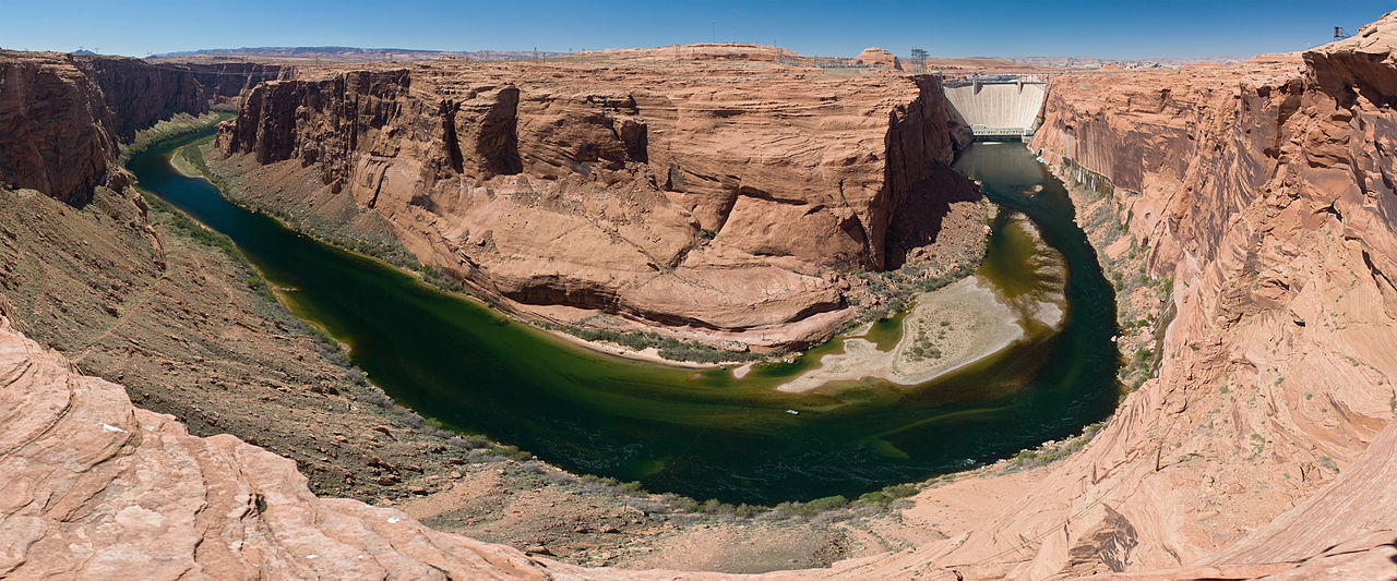
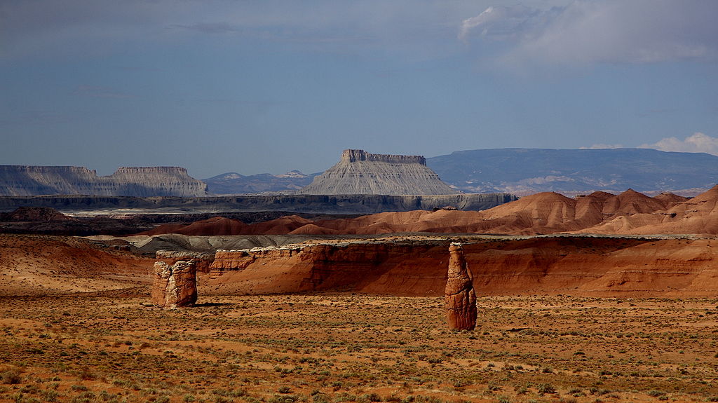
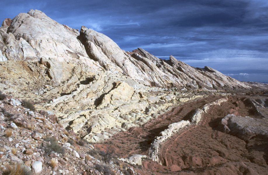
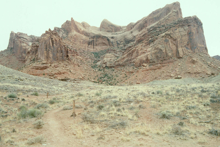
Glen Canyon is one example of a natural feature that has been modified by humans.
This page provides information on Hydrology, Geology,
the Environment and a Glossary of geologic, hydrologic and environmental terms.
The Utah Geology section provides an expandable, clickable map courtesy of and used with the permission of the Utah Geological Survey.
Hydrology
Hydrology is the scientific study of the movement, distribution and management of water on Earth and other planets,
including the water cycle, water resources and environmental watershed sustainability.[1]
Water is one of our most important natural resources.
Without water there would be no life on earth.
But Earth's water supply is limited and isn't always where humans and other living organisms need it.
Chemical wastes improperly discarded in the past are appearing in today's water supplies.
Hydrology knowledge and application help scientists and the public respond to the dynamics of complex water systems and solve water-related problems.
Hydrologists play a vital role in finding those solutions.[1]
In 1878, Powell published
Report on the Lands of the Arid Regions of the United States.
Most homestead acts granted settlers 160 acres, but Powell thought that if water was limited, that was too much land.
He wanted the federal government to use land for other purposes, and wrote about dividing land by its altitude, with high elevation land dedicated to timber,
middle land to grazing and low elevation land for farming.[2]
Powell proposed that western waterways should define state boundaries.
But government surveyors in Washington, D.C. decided that straight lines were sufficient for dividing vast western territories.
Every state west of a line from North Dakota to Texas has a straight line border, including Wyoming and Colorado, home of the Rocky Mountains.[2]
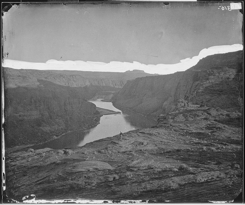
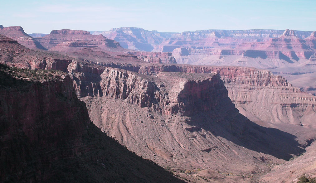
Glen Canyon in 1873 near the confluence
of the Colorado and San Juan Rivers T. H. O'Sullivan U.S. National Archives and Records Administration
https://en.wikipedia.org/wiki/Glen_Canyon#/media/ File:CANYON_OF_THE_COLORADO_ RIVER_NEAR_MOUTH _OF_SAN_JUAN_RIVER_-_NARA_-_524266.jpg
public domain
In the eastern U.S. most dams are privately owned.
Powell was convinced that waterways in the west should be controlled by the federal government in order to establish a new and extensive infrastructure to support western settlers.[2]
Powell died in 1902, the same year the U.S. Bureau of Reclamation was created.
For the next 60 years, the bureau planned, supervised and completed construction of western dams at high altitudes and irrigation systems at lower altitudes,
as Powell had recommended.[2]
The dams built by the bureau formed reservoirs.
Hoover Dam created 120 mile-long Lake Mead.
Glen Canyon Dam created 185-mile-long Lake Powell.
In 1983, University of Arizona Tree Ring researchers warned:
Our results show that the projected climatic change would have serious overall effects on the west.
The number of sub-regions that are expected to have water shortages by the year 2000 would essentially double. The regions drained by the Colorado River
and the Rio Grande would be especially hard hit as there is presently little, if any, unallocated water in these basins. Allocation changes required to meet a diminishing
water supply would be extremely difficult in these basins due to the complex web of international treaties, interstate compacts and both federal and local laws.[3]
When Lakes Mead and Powell are full, they can hold nearly four years of Colorado River water, but a drought that began in 2000 has caused significant drops in both lakes.[2]
Sources:
[1]
U.S.G.S. What is Hydrology?
https://www.usgs.gov/special-topic/water-science-school/science/ what-hydrology?qt-science_center_objects=0#qt-science_center_objects
Glen Canyon Dam C. Mehlführer April 12, 2008 Wikipedia Glen Canyon
https://en.wikipedia.org/wiki/Glen_Canyon#/ media/File:Glen_Canyon_Dam_MC.jpg CC BY 2.5
[2]
Glennon, R. (June 26, 2019). John Wesley Powell, Great Explorer of the American West. University of Arizona College of Law. Scientific American.
https://blogs.scientificamerican.com/observations/john-wesley-powell-great-explorer-of-the-american-west/
[3]
Stockton, C. W. (July, 1983). Final Report Submitted to the National Science Foundation:
Projected Effects of Climatic Variation upon Water Availability in Western United States. Laboratory of Tree Ring Research. University of Arizona.
https://repository.arizona.edu/bitstream/handle/10150/303523/ltrr-0048.pdf?sequence=1&isAllowed=y
Water Properties
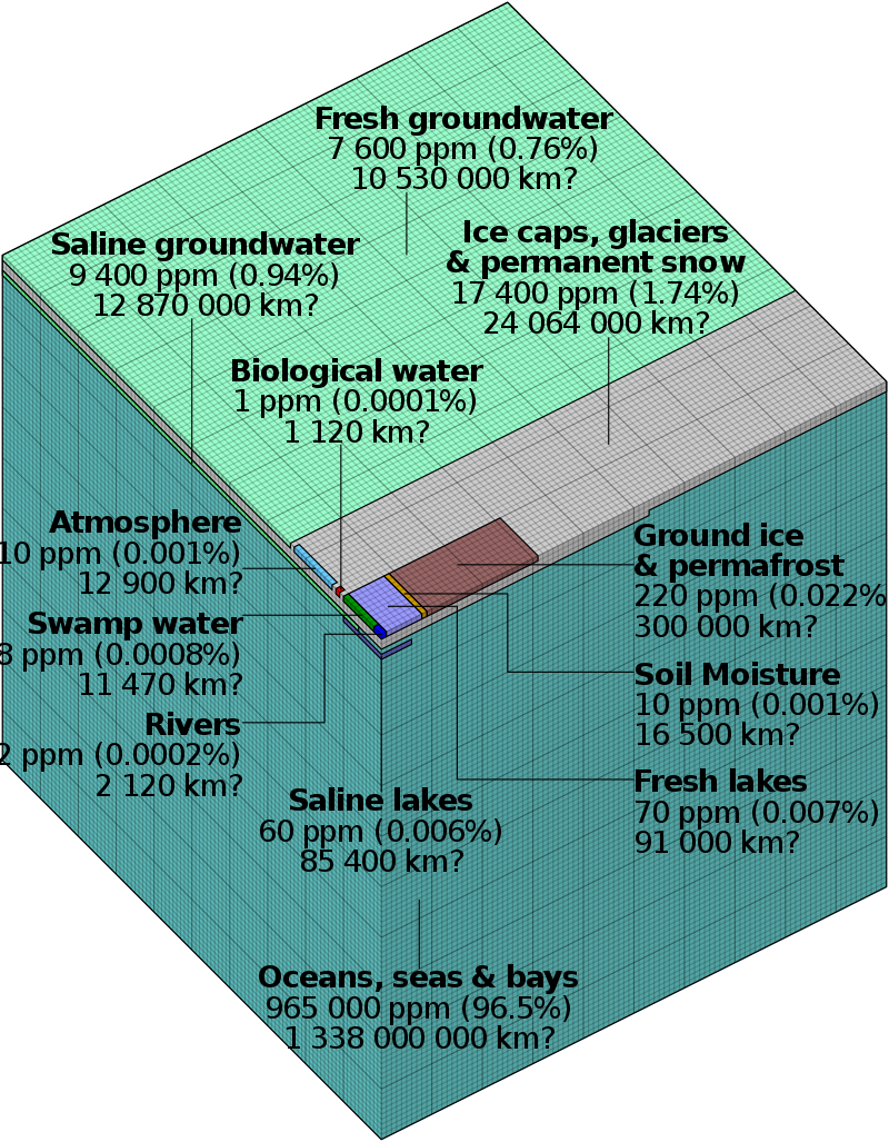
More than 70% of Earth's surface is covered by water.
Scientists estimate that the
hydrosphere.
contains about 1.36 billion cubic kilometers of water.
The second most common form of the water molecule on our planet is ice.
If all of Earth's ice melted, sea-level would rise by about 70 meters.[1]
Water has several interesting and unique properties:
Bonding:
Water consists of 2 hydrogen atoms bonded to one oxygen atom, designated as H2O, or dihydrogen monoxide.
Water is a polar molecule because the hydrogen side of the water molecule has a slight positive charge, and the oxygen side a negative charge.[1]
Universal solvent:
Because of its molecular structure, water can dissolve a large number of different chemical compounds.
Water can carry solvent nutrients in runoff, infiltration, groundwater flow, and living organisms.[1]
High surface tension:
Its molecular bonding makes it adhesive and elastic, and tends to aggregate in drops rather than spread out over a surface.
Water tends to stick to the sides of vertical structures despite gravity's downward pull.
Its high surface tension also allows water droplets and waves to form.
It also allows plants to move water from their roots to their leaves.[1]
Electrochemistry:
Water's atomic structure provides unique
electrochemical
properties.
Because it is a polar molecule, its bonds are strong.[1]
Conductivity:
Water conducts heat more easily than any liquid except mercury which causes large bodies of liquid water like lakes and oceans
to have a fairly uniform vertical temperature profile.[1]
High specific heat:
Because water has a high
specific heat
, it can absorb large amounts of heat energy before it begins to get hot.
It also means that water releases heat energy slowly when situations cause it to cool.
Water's high specific heat allows for the moderation of the Earth's climate and helps organisms regulate their body temperature more effectively.[1]
Neutral pH:
In a pure state water has a neutral
pH
of about 7, so it is neither acidic nor alkaline.
Water changes its pH when substances are dissolved in it.
Rain has a naturally acidic pH of about 5.6 because it contains natural derived carbon dioxide and sulfur dioxide.[1]
Solids, Liquids and Gases of Water Molecules Royal of Chemistry September 24, 2014
YouTube https://edu.rsc.org/resources/the-life-of-water/1651.article#!cmpid=CMP00006694 CC BY-ND 4.0
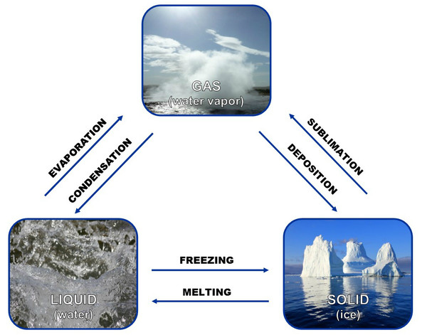
Phases:
Water molecules are the only substance on Earth that exist in all three physical states, as a solid, a liquid, and a gas.
Incorporated in the changes of state are massive amounts of heat exchange which play an important role in heat redistribution in Earth's atmosphere.
Approximately 3/4ths of this process is accomplished by water evaporation and condensation.[1]
Liquid:
Water molecules exist in liquid form over an important range of temperature from 0o to 100o Celsius.
This range allows water molecules to exist as a liquid in most places on our planet.[1]
Life:
Water is the major constituent of almost all life forms.
Most animals and plants contain more than 60% water by volume.
Without water life would probably never have developed on our planet.[1]
Volume:
Unlike most substances, freezing water molecules causes their mass to occupy a larger volume.
When water freezes it expands rapidly, adding about 9% by volume.
Fresh water has a maximum density at around 4o Celsius.
Water is the only substance on this planet where the maximum density of its mass does not occur when it becomes solidified.[1]
Sources:
[1]
PhysicalGeography.net. Physical Properties of Water.
http://www.physicalgeography.net/fundamentals/8a.html
Water Phase Changes
Phase Changes Water's Three Physical States Healing Earth
https://healingearth.ijep.net/water/waters-three-physical-states CC0 public domain
In order for water to change from a solid to liquid and then to a gas, a water molecule must gain energy.
The energy absorbed by water is used to break hydrogen bonds among molecules.
When the bonds are broken between ice molecules it melts and the molecules can circulate as liquid water.[1]
The energy required to convert ice into water is called the
latent heat of fusion.
It takes about 80 calories of heat to convert one gram of ice into water.
The energy required to convert water into steam is called the
latent heat of evaporation.
It takes about 600 calories of heat to convert one gram of water into steam.[1]
Most of us are familiar with freezing, when liquid water undergoes a phase change and converts to solid ice, and melting, when water also undergoes a phase change
from solid ice to liquid water.
When heat is added to liquid water it changes to water vapor, dissipating in the atmosphere. When water vapor in the atmosphere cools, it undergoes condendensation.
The two phases we seldom see in daily life are
sublimation,
when ice converts directly into water vapor in the atmosphere, and
deposition,
when water vapor converts directly into solid ice.
Sublimation can be observed by blowing across the tops of ice cubes in an ice cube tray.
Sources:
[1]
The Physical Environment. Phases of Water.
https://www.earthonlinemedia.com/ebooks/tpe_3e/ atmospheric_moisture/phase_changes.html
Water Cycle J. Evans & H. Perlman Wikipedia Water Cycle
https://en.wikipedia.org/wiki/Water_cycle#/ media/File:Watercyclesummary.jpg public domain
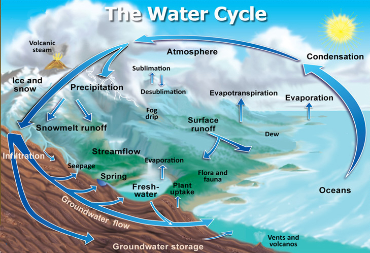
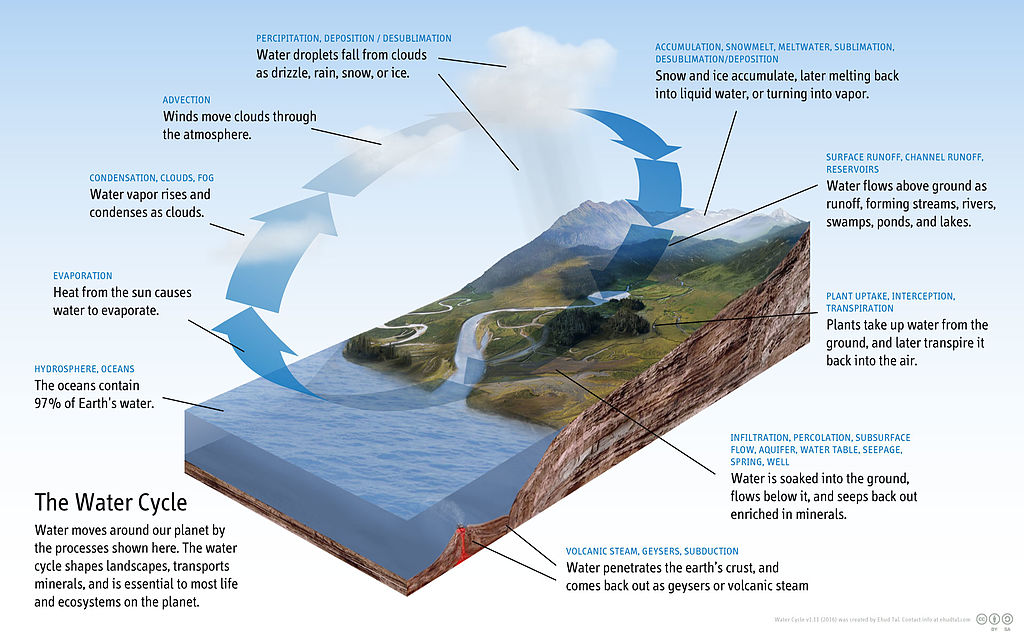
Hydrologic Cycle
The hydrologic cycle explains water's motion among oceans, continents, and atmosphere.
Water motion is powered by gravity and the Sun.
About 97.5% of Earth's water is contained in the oceans, 2.5% in polar ice caps and ground water, and 0.0001% in the atmosphere.[1]
A water molecule will stay in the ocean for about 3,000 years before it is evaporated and added back into the water cycle.
It will remain in the atmosphere for about 10 days before falling as rain, snow or condensation back into the oceans or onto land.
Once on land, water can seep into the ground, flow across the surface and enter streams, rivers, or lakes, or become part of a glacier in colder environments.[1]
Plants use a lot of water and return it to the atmosphere by
transpiration.
There is no net water loss in the atmosphere, biosphere, and
cryosphere,
but overall global distribution changes due to climatic variations and global warming.[1]
Sources:
[1]
Milligen, M. (April, 1999). Do You Have Any Information on the Hydrologic Cycle Specific to Utah? Survey Notes, 31 (2). Utah Geolgical Survey.
https://geology.utah.gov/map-pub/survey-notes/ glad-you-asked/utahs-hydrologic-cycle/
Water Balance
Water Movement E. Tal February 26, 2016 Wikipedia Water Cyclec
https://en.wikipedia.org/wiki/Water_cycle#/ media/File:Diagram_of_the_Water_Cycle.jpg public domain
Water changes state from vapor to liquid to a solid under natural conditions.
Within a specific area over a specific period of time, water inflows are equal to water outflows, plus or minus any storage changes.
This means that water entering an area has to leave or be stored in that the area.[1]
The simplest form of water balance equation is:
P = Q + E ± ΔS
P = precipitation, Q = runoff, E = evaporation and ΔS = storage in soil, aquifers or reservoirs.[1]
A water balance analysis has two main applications. It can be used to assess current status and trends in water resource availability in an area over a specific period of time,
and strengthen water management decision-making, by assessing and improving the validity of scenarios and strategies.[1]
Water balance analysis divides water into "green" and "blue" water.
"Blue" water, having been used for irrigation, is the surface and groundwater available for irrigation urban and industrial use and environmental flows.
"Green" water, from rainfall, is water that has been stored in the soil and that evaporates into the atmosphere.[1]
Sources:
[1]
Stauffer, B. Water Balance Estimation.
https://sswm.info/sswm-university-course/module-4-sustainable-water-supply/further-resources-water-sources-software/water-balance-estimation
Hydrology Resources
Arizona Department of Water Resources. Arizona's Water Supplies.
http://www.arizonawaterfacts.com/water-your-facts
Arizona Department of Water Resources. Colorado River Drought Contingency Planning June 28, 2018 - Present.
https://new.azwater.gov/lbdcp
Arizona Department of Water Resources. Colorado River Management.
https://new.azwater.gov/crm
Bailey, J. (June, 2010). Reclamation and Arizona: Too Much Water or Not Enough. United States Department of the Interior Bureau of Reclamation.
https://www.usbr.gov/lc/phoenix/AZ100/1899/toomuchwater.html
Bannister, B., Dean, J. S., & Robinson, W. J. (1969). Tree-Ring Dates From Utah S-W: Southern Utah Area. Laboratory of Tree-Ring Research, University of Arizona.
https://repository.arizona.edu/bitstream/handle/10150/220694/tree-ring_dates_utah_s-w.pdf?sequence=3&isAllowed=y
Bureau of Reclamation. Colorado River Basin Water Supply and Demand Study.
https://www.usbr.gov/lc/region/programs/crbstudy.html
Central Arizona Project. (August, 2012). Colorado River Basin Major River Diversions.
https://www.cap-az.com/documents/departments/planning/colorado-river-programs/River-Diversions.pdf
City of Tucson. Conservation Programs.
https://www.tucsonaz.gov/water/residential-and-commercial-conservation
Derouin, S. (November 3, 2017). Utah's Great Salt Lake has Lost Half Its Water. Science.
https://www.sciencemag.org/news/2017/11/utah-s-great-salt-lake-has-lost-half-its-water-thanks-thirsty-humans
Editors of Encyclopaedia Britannica. Hydrosphere. Encyclopaedia Britannica.
https://www.britannica.com/science/hydrosphere/Origin-and-evolution-of-the-hydrosphere
Fahlund, A., Choy, M. L. J. & Szeptycki, L. (2014). California Journal Politics Policy, 6(1), 61-102.
https://escholarship.org/uc/item/0685t8n2
Kyle, J. L. (June 8, 1981). Arizona's New Groundwater Statute: 1980 Groundwater Management Act: Outline.
https://scholar.law.colorado.edu/cgi/viewcontent.cgi?article=1010&context=water-resources-allocation-laws-and-emerging-issues
National Snow & Ice Data Center. Glacier Quick Facts.
https://nsidc.org/cryosphere/glaciers/quickfacts.html
National Weather Service. Advanced Hydrologic Prediction Service.
https://water.weather.gov/ahps2/index.php?wfo=slc
Stockton, C. (July, 1983). Projected Effects of Climatic Variation Upon Water Availability in Western United States (Progress Report). Laboratory of Tree-Ring Research, University of Arizona.
https://repository.arizona.edu/handle/10150/303523
U.S.G.S. Utah Water Science Center.
https://www.usgs.gov/centers/ut-water/
Utah Division of Water Rights. Glossary of Water Words.
https://www.waterrights.utah.gov/wrinfo/glossary.asp
Utah Geological Survey. Groundwater Resources/Hydrology Publications.
https://geology.utah.gov/resources/groundwater/groundwater-resources/
Utah State University. Utah Water Research Laboratory.
https://uwrl.usu.edu/water-resources/index
Geology
Geology is the study of the Earth's interior and exterior and the processes that shape its mantle, crust and
lithosphere.
It incorporates
thermodynamics,
mechanics,
chemistry and mathematics.
Geologists study the causes of plate tectonics, earthquakes, volcanoes, rock and mineral formation, mountain building, ocean and river changes, groundwater depletion and pollution,
glacier movement and climate change. They evaluate the effects of natural and
anthropogenic
changes on planet Earth and all of its systems.
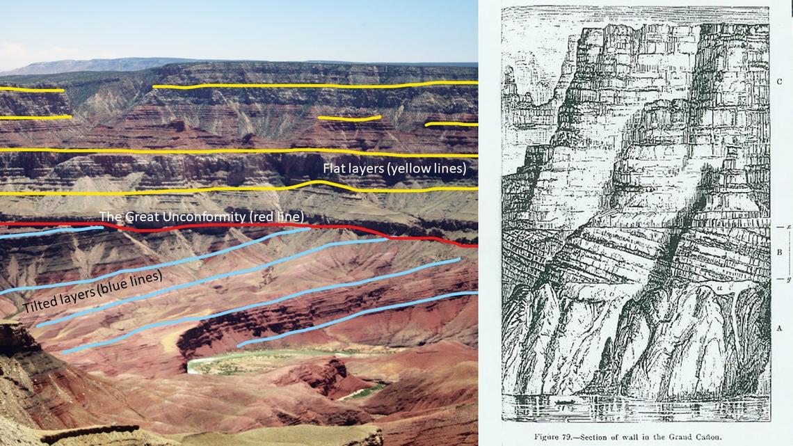
John Wesley Powell was a pioneering, self-taught geologist.
From his writing, it is obvious that he was aware of
geologic principles.
Powell identified unconformities, gaps in the geologic record that represent missing time.
He was the first geologist to sketch the Great Unconformity in the Grand Canyon.[1]
Powell's 1875 drawings of the Grand Canyon
The image on the left is a recent photograph of Grand Canyon from Walhalla Plateau, with the red line showing the Great Unconformity that was first noted by Powell.
The image on the right is a stratigraphic section. A. Scott. April 15, 2019 John Wesley Powell Expedition U.S.G.S.
https://www.usgs.gov/center-news/powell-expedition-geologic-time -then-and-now?qt-news_science_products=1#qt-news_science_products public domain
His western expeditions and surveys contributed to the establishment of the United States Geological Survey (U.S.G.S.) in 1879.
When the first U.S.G.S. director, Clarence King resigned in March 1881, Powell became the organization's director at King's suggestion.
Powell promoted a national topographic mapping system, supported a systematic study of
hydrography,
and advocated conservation of the west.[1]
Powell's support of single
geodetic
and topographic systems remain the foundation of federal mapping standards.
In 1884 speech to Congress Powell stated, "A Government cannot do any scientific work of more value to the people at large than by causing
the construction of proper topographic maps of the country."[1]
Powell understood that future generations would require accurate and precise mapping systems.
His efforts lead to generations eventually led to the nationwide 1:24,000-scale topographic map series used everywhere in the U.S. except Alaska.[1]
[1]
U.S.G.S. Powell Expedition-Geologic Time. Then and Now.
https://www.usgs.gov/center-news/powell-expedition-geologic- time-then-and-now?qt-news_science_products=1#qt-news_science_products
Geologic Principles
Cross-cutting relationships:
A rock layer cross-cut by a fault, rock intrusion or an erosion surface is older than the cross-cutting feature.[1]
Faunal succession:
Fossils exhibit identifiable patterns and characteristics which change over time.
In almost every case, rocks containing a particular fossil were deposited during the time that living creature existed on Earth.[1]
Organic evolution:
This is the process by which new species of organisms develop from earlier life forms and slowly change over long periods of geologic time.[1]
Organic extinction:
Mass extinction events with widespread and rapid termination of organisms, as well as rapid increases in diversity of lifeforms,
are used as major divisions in the geologic time scale. The extinction of dinosaurs at the end of the Mesozoic Era is the best known extinction event.[1]
Original horizontality:
Layers of sediment are originally deposited horizontal to the Earth's surface. Folded or tilted layers tell a story of change that occurred after deposition.[1]
Superposition:
Undisturbed sedimentary layers or beds are ordered sequentially with the oldest at the bottom and the youngest at the top.[1]
Uniformitarianism:
Geologic processes operating on the Earth's crust today have acted in a similar manner and relative intensity throughout geologic time.
Understanding the present is the key to understanding the past.[1]
Sources:
[1]
National Park Service. Fundamental Geologic Principles.
https://www.nps.gov/subjects/geology/fundamental-geologic-principles.htm
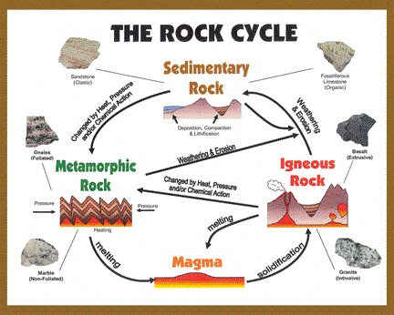
Rock Cycle
Rock Cycle U.S.G.S. January 6, 2007 Wikipedia Rock Cycle
https://simple.wikipedia.org/wiki/ Rock_cycle#/media/File:Rockcyc.jpg public domain
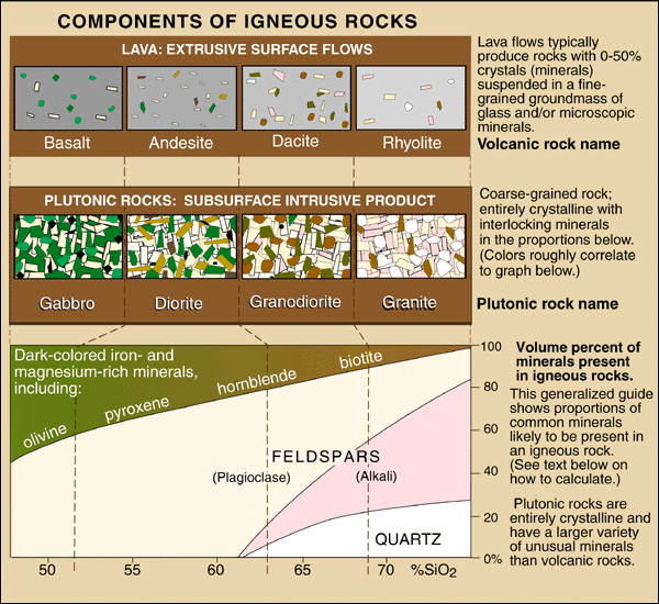
Igneous rocks form when hot, molten rock, lava or magma, crystallizes and solidifies.
The molten rock forms within the Earth near active plate boundaries and hot spots.[1]
Common igneous rocks include
andesite,
basalt,
dacite,
diorite,
dolerite,
gabbro,
nepheline,
obsidian,
peridotite,
scoria,
tuff,
and
volcanic bombs.
[4]
Intrusive, or plutonic, igneous rock forms when magma is trapped deep inside the Earth, where it cools slowly over many thousands or millions of years
until it solidifies into large blocks or crystals.
Intrusive rocks have a coarse grained texture.[1]
Extrusive, or volcanic, igneous rock forms when magma erupts, becoming lava, and cools near or on Earth's surface.
It cools and solidifies quickly when exposed to the lower temperature atmosphere.
Its crystals are smaller than those of extrusive rock and those crystals have a very fine-grained or glassy texture.
Trapped gas bubbles forming bubbly, vesicular textures.[1]
Sedimentary rocks form from existing rocks or pieces of once-living organisms deposited in layers on Earth's surface, often in rivers, streams, and lakes.
Many southwest mesas and arches are made of sedimentary rock.[2]
Common sedimentary rocks include
breccia,
clay,
conglomerates,
feldspar,
limestone,
mica,
sandstone,
and
shale.
[4]
Buried sediments lonse water, and become cemented for form rock.
Tuff-like sandstones contain volcanic ash.[2]
Clastic sedimentary rocks are made up of
clasts
of pre-existing rocks loosened by weathering, then transported to a river, lake or stream.
These rocks may have particles ranging in size from microscopic clay to huge boulders.
Their names are based on their clast size.
The smallest grains are clay.
Silt is slightly larger, followed by sand.
Grains larger than 2 millimeters are called pebbles.[2]
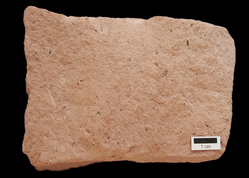
Shale is made mostly of clay, siltstone is made up of silt-sized grains, sandstone is made of sand-sized clasts,
and conglomerate is made of pebbles surrounded by a matrix of sand or mud.[2]
The most dominant mineral in sandstone is
quartz
because it is the most common mineral in the Earth's surface crust.[4]
Biologic sedimentary rocks form when large numbers of living things die and are then compressed.
Chert and limestone are types of biologic sedimentary rock.[2]
Metamorphic rocks are formed from igneous and sedimentary rock subjected to high heat, high pressure, or hot mineral-rich fluids, inside the Earth near tectonic plate boundaries.
Metamorphism transforms these rocks into denser rocks consisting of new minerals created by rearrangement of existing mineral components or by reactions with fluids entering the rocks.[3]
Common metamorphic rocks include
amphibolite,
eclogite,
gneiss,
hornfels,
marble,
migmatite,
phyllite,
quartzite,
schist,
serpentinite,
and
slate.
[4]
Foliated metamorphic rocks include granite gneiss and
biotite
schist, which are strongly banded or foliated.
Foliation forms when pressure flattens or elongates minerals in a rock into a linear alignment.
These rocks develop a platy, sheet-like structure that demonstrates the direction that pressure was applied.[3]
Non-foliated metamorphic rocks do not have a platy or sheet-like structure because even under high pressure or temperature, it is not possible to change their mineral structures.[3]
Contact metamorphism occurs when hot igneous rock intrudes into some pre-existing rock baked by the heat, changing the mineral structure of the rock without addition of pressure.[3]
Sources:
[1]
U.S.G.S. What are Igneous Rocks?
https://www.usgs.gov/faqs/what-are-igneous-rocks?qt-news_science_products=0#qt-news_science_products
[2]
U.S.G.S. What are Sedimentary Rocks?
https://www.usgs.gov/faqs/what-are-sedimentary-rocks-0?qt-news_science_products=0#qt-news_science_products
[3]
U.S.G.S. What are Metamorphic Rocks?
https://www.usgs.gov/faqs/what-are-metamorphic-rocks-0?qt-news_science_products=0#qt-news_science_products
[4]
ZME Science. The types of rock: Igneous, Metamorphic and Sedimentary.
https://www.zmescience.com/other/science-abc/types-of-rock/
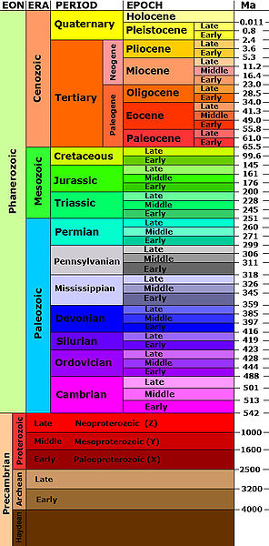
Geologic Timescale June 24, 2009 Wikipedia Geologic Time
https://commons.wikimedia.org/wiki/File:Geologic_time_scale.jpg public domain
Geologic Time
One of the earliest estimates of Earth's age was done by William Thompson, also known as Lord Kelvin.
In 1862 Kelvin used thermodynamic modeling to estimate Earth's age at between 20 and 400 million years.
Kelvin's model disagreed significantly with geologists' estimates, primarily because Kelvin made some incorrect assumptions about Earth's internal cooling rate.
In 1869, when Powell began his expedition, English scientist Thomas Huxley challenged Lord Kelvin's calculations.
Radioactivity, discovered in 1896, changed science's view of Earth's internal thermodynamics.[1]
In 1788, James Hutton proposed what would become the foundational principle of geology: uniformitarianism.
This principle states that the processes that we see happening on Earth today are the same processes that shaped Earth in the past,
and that they will continue into the future.
Hutton reasoned that if sand was deposited on a river point bar at a rate of about 2 to 5 centimeters per year, then vast sandstones must also have been deposited at that very slow rate.
At the famous unconformity at Siccar Point in Scotland, Hutton said of geologic time that it had "no vestige of a beginning. No prospect of an end."[1]
The next breakthrough in understanding of geologic time came from English road surveyor William Smith, who was also an amateur paleontologist.
He noticed that fossils occurred in distinctive groups and that their order was the same everywhere he identified them.
In 1815, Smith developed the law of faunal succession which states that species become extinct, are replaced by new species and that characteristic fossils of a certain age are that age everywhere.[1]
Major advances were made in
geochronology.
From the 1820s to the 1850s scientists developed a geologic time scale, published in 1841, based on characteristic fossils.
Because a lot of the geologic time scale work was done in England, many geologic period names are derive from English locations.[1]
Sources:
[1]
U.S.G.S. Powell Expedition-Geologic Time. Then and Now.
https://www.usgs.gov/center-news/powell-expedition-geologic- time-then-and-now?qt-news_science_products=1#qt-news_science_products
Geology Resources
Arizona Geological Survey. Center for Natural Hazards.
https://azgs.arizona.edu/center-natural-hazards
Arizona Geological Survey. Document Repository.
http://repository.azgs.az.gov/uri_gin/azgs/dlio/1844
Arizona Geological Survey. Photo Gallery.
https://azgs.arizona.edu/photo-gallery
Atwood, G. (1994). Geology of Utah. Utah History Encyclopedia.
https://www.uen.org/utah_history_encyclopedia/g/GEOLOGY.shtml
Editors of Encyclopaedia Britannica. Geologic Time. Encyclopedia Britannica.
https://www.britannica.com/science/geologic-time
Fox, D. (Winter, 2020). Hush...A Growing Body of Research Shows That Noise Can Be Harmful to Humans and Animals. Can Natural Quiet Be Saved?
National Parks Conservation Association.
https://www.npca.org/articles/2391-hush
Gehrels, G. E. & Spencer, J. E. (1990). Geologic Excursions Through the Sonoran Desert Region, Arizona and Sonora.
Arizona Geological Survey.
http://repository.azgs.az.gov/sites/default/files/dlio/files/nid1844/specialpaper-7202p.pdf
Geohazards Research Group. Red Rock Tones: The Hidden Music of Utah's Arches. University of Utah. (Note: computer and headphones required;
most phones cannot play the arch sound frequencies.)
https://geohazards.earth.utah.edu/tones/
Gray, Z. (1922). Tales of Lonely Trails.
http://www.gutenberg.org/files/12225/12225-h/12225-h.htm
Kirkegaard, J. (September, 2017). Transmission.
http://fonik.dk/works/transmission.html
Klein, J. (September 17, 2019). Taking the Pulse of a Sandstone Tower in Utah. The New York Times.
https://www.nytimes.com/2019/09/09/science/castleton-tower-utah-vibration.html
Lee, W. (1927). Stories in Stone. National Park Service.
https://www.nps.gov/parkhistory/online_books/stories_in_stone/index.htm
Lyell, C. (May 24, 1853). Principles of Geology. 9th ed.
https://www.gutenberg.org/files/33224/33224-h/33224-h.htm
Mindat.org. Learning Center.
https://www.mindat.org/a/learn
Moore, J., et al. Red Rock Tones: The Hidden Music of Utah's Arches.
https://geohazards.earth.utah.edu/tones/
National Park Service. Fundamental Geologic Principles.
https://www.nps.gov/subjects/geology/fundamental-geologic-principles.htm
National Park Service. The NPS Celebrates Successful Completion of Air Tour Management Agreements at Glen Canyon NRA and Rainbow Bridge NM.
https://www.nps.gov/articles/viewfromabove.htm
PBS. Geology of the Grand Canyon.
https://www.pbs.org/wgbh/americanexperience/features/canyon-geology/
Ralph, J. The Most Common Minerals on Earth. Mindat.org.
https://www.mindat.org/a/common_minerals
U.S.G.S. (1983). Energy Resources, Map 68.
https://ngmdb.usgs.gov/Prodesc/proddesc_100009.htm
U.S.G.S. Geologic Map of Arches National Park Area, Grand County, Utah
https://ugspub.nr.utah.gov/publications/maps/m-102.pdf
U.S.G.S. Geologic Map of Grand Staircase Escalante National Monument.
https://ugspub.nr.utah.gov/publications/public_information/pi-56.pdf
U.S.G.S. Geology and Ecology of National Parks.
https://www.usgs.gov/science-support/osqi/yes/national-parks/
U.S.G.S. Geothermal Resources.
https://ugspub.nr.utah.gov/publications/open_file_reports/ofr-431/ofr-431_temp-gradient-boreholes-utah-map.pdf
U.S.G.S. Grand Canyon Geology.
https://www.usgs.gov/science-support/osqi/yes/national-parks/grand-canyon-geology
U.S.G.S. Postcard Geologic Map of Utah.
https://ugspub.nr.utah.gov/publications/public_information/pi-81.pdf
U.S.G.S. Rock Formations in the Colorado Plateau of Southeastern Utah and Northern Arizona.
https://www.nps.gov/parkhistory/online_books/geology/publications/pp/132-A/contents.htm
University of Utah. Dynamics of Rock Arches.
https://geohazards.earth.utah.edu/arch.html
Utah Geological Survey.
https://geology.utah.gov/
Windley, B. F. & Harbaugh, J. W. Geology. Encyclopedia Britannica.
https://www.britannica.com/science/geology
Utah Geology
Utah Geologic Map Portal Courtesy of the Utah Geological Survey https://geology.utah.gov/apps/intgeomap/#
used with written permission of Utah Geological Survey
Environment
See the links below for environmental science-related resources, state and federal laws and regulations and environmental programs.
Environmental Resources
Airnow.gov.
https://www.airnow.gov/
Center for Biological Diversity.
https://biologicaldiversity.org/
Center for Biological Diversity. (July 24, 2019). FOIA Rule Complaint.
https://www.biologicaldiversity.org/campaigns/open_government/pdfs/2019-07-24-19-2198-FOIA-Rule-Complaint.pdf
Center for Biological Diversity. (July 24, 2019). FOIA Rule Complaint Press Release.
https://biologicaldiversity.org/w/news/press-releases/lawsuit-challenges-political-meddling-epa-public-records-changes-2019-07-24/
Earth Day. Daily Challenge.
https://www.earthday.org/?gclid=CjwKCAjw7LX0BRBiEiwA__gNw_M7_L4Lokaw1Qm8-tn3bFi0Z50XiipPhsapzo0bfy8Pk9YtKaURMRoC1C0QAvD_BwE
Editors of Encyclopaedia Britannica. Lithosphere. Encyclopaedia Britannica.
https://www.britannica.com/science/lithosphere
Environmental Protection Agency. Criteria Air Pollutants.
https://www.epa.gov/criteria-air-pollutants#self
Environmental Protection Agency. Environmental Topics.
https://www.epa.gov/environmental-topics
Gates, D. M., Thompson, J. N. & Thompson, M. B. Biosphere. Encyclopaedia Britannica.
https://www.britannica.com/science/biosphere
International Dark Sky Association.
https://www.darksky.org/
Meyer, R. (March 29, 2017). How the U.S. Protects the Environment, From Nixon to Trump.
https://www.theatlantic.com/science/archive/2017/03/how-the-epa-and-us-environmental-law-works-a-civics-guide-pruitt-trump/521001/
NASA Goddard Institute for Space Studies. Datasets and Images.
https://data.giss.nasa.gov/
NASA Goddard Institute for Space Studies. Publications.
https://pubs.giss.nasa.gov/
National Environmental Health Association. Definitions of Environmental Health.
https://www.neha.org/about-neha/definitions-environmental-health?fbclid=IwAR1oa5iLlWt40VmLoHV3gSMUrn-28xR2mL4cReyvTvarRpPjJPgwoc_e3zg
National Snow & Ice Data Center. Cryosphere.
https://nsidc.org/cryosphere/allaboutcryosphere.html
Nature Climate Change. (May 28, 2019). Lobbying for and Against Climate Solutions, 9, 427.
https://www.nature.com/articles/s41558-019-0499-4
Pielke, R. A. Atmosphere. Encyclopaedia Britannica.
https://www.britannica.com/science/atmosphere
Society of Environmental Journalists.
https://www.sej.org/
Thomsen, P. E., & Willerslev, E. (March, 2015). Environmental DNA – An Emerging Tool in Conservation for Monitoring Past and Present Biodiversity. Biological Conservation, 183, 4-18.
https://www.sciencedirect.com/science/article/pii/S0006320714004443?fbclid=IwAR3piiyfBLjvmFdrjSkEtlwQhczF676N6yniHogWH5dCa2ZKdfKPlOiHiz0
Environmental Laws and Regulations
United States Environmental Protection Agency
July 24, 2016 Wikipedia United States Environmental Protection Agency
https://en.wikipedia.org/wiki/ United_States_Environmental_Protection_Agency#/ media/File:Logo_of_the_United_States_
Environmental_Protection_Agency.svg
public domain
Bødker, H., & Neverla, I. (2012). Environmental Journalism. Journalism Studies, 13, 2.
https://www.tandfonline.com/doi/abs/10.1080/1461670X.2011.646394?journalCode=rjos20
Center for International Environmental Law.
https://www.ciel.org/
Inter Ocean. (March 1, 1880). The Desert Makers, 3.
https://www.newspapers.com/clip/25397266/desert-makers/
Environmental Law Reporter. Code of Federal Regulations.
https://elr.info/administrative/code-of-federal-regulations-outline
Environmental Law Reporter. Current Weekly Cases Update.
https://elr.info/judicial/cases-update
Environmental Law Reporter. Executive Orders.
https://elr.info/administrative/executive-orders
Environmental Law Reporter. Federal Laws.
https://elr.info/legislative/congressional-update
Environmental Law Reporter. Recent Federal Bills.
https://elr.info/legislative/federal-laws
Environmental Law Reporter. State Laws.
https://elr.info/legislative/state-laws
Environmental Law Reporter. State Regulations.
https://elr.info/administrative/state-regulations
Environmental Protection Agency. Freedom of Information Act Reports.
https://www.epa.gov/foia/foia-reports
Environmental Protection Agency. Laws and Regulations.
https://www.epa.gov/laws-regulations
Environmental Protection Agency. Summary of the Administrative Procedure Act 5 USC §551 et seq. (1946).
https://www.epa.gov/laws-regulations/summary-administrative-procedure-act
EnvironmentalScience.org. Environmental Law: Government and Public Policy Towards the Environment.
https://www.environmentalscience.org/environmental-law
FindLaw. Overview: Key Federal Environmental Laws.
https://smallbusiness.findlaw.com/business-laws-and-regulations/overview-key-federal-environmental-laws.html
Society of Environmental Journalists. Guide to Diversity in Environmental Reporting.
https://www.sej.org/sites/default/files/SEJ-Guide-to-Diversity-in-Environmental-Reporting.pdf
Environmental Programs
Arizona Sonora Desert Museum. Current Projects - Research and Conservation.
https://www.desertmuseum.org/center/current_projects.php
United Nations Environment Programme.
https://www.unenvironment.org/
Glossary
ABCDEFGHIJKLMNOPQRSTUVWXYZ
A ↑
acid
refers to a substance with a pH less than 7
agriculture
the science or practice of farming
alkali
a chemical compound that neutralizes or effervesces with acids, a caustic or corrosive substance such as lime or soda
alkaline
refers to a substance with a pH greater than 7
alluvial plain
a largely flat landform created by the deposition of sediment over a long period of time by one or more rivers coming from highland regions, from which alluvial soil forms
aluminosilicate
a silicate in which aluminum replaces some of the silicon, especially a rock-forming mineral such as a feldspar or a clay mineral
amino acid
a simple organic compound containing both a carboxyl (-COOH) and an amino (-NH2) group
amphibole
an important group of inosilicate minerals, forming prism or needlelike crystals, composed of double chain SiO4
amphibolite
a granular metamorphic rock consisting mainly of hornblende and plagioclase
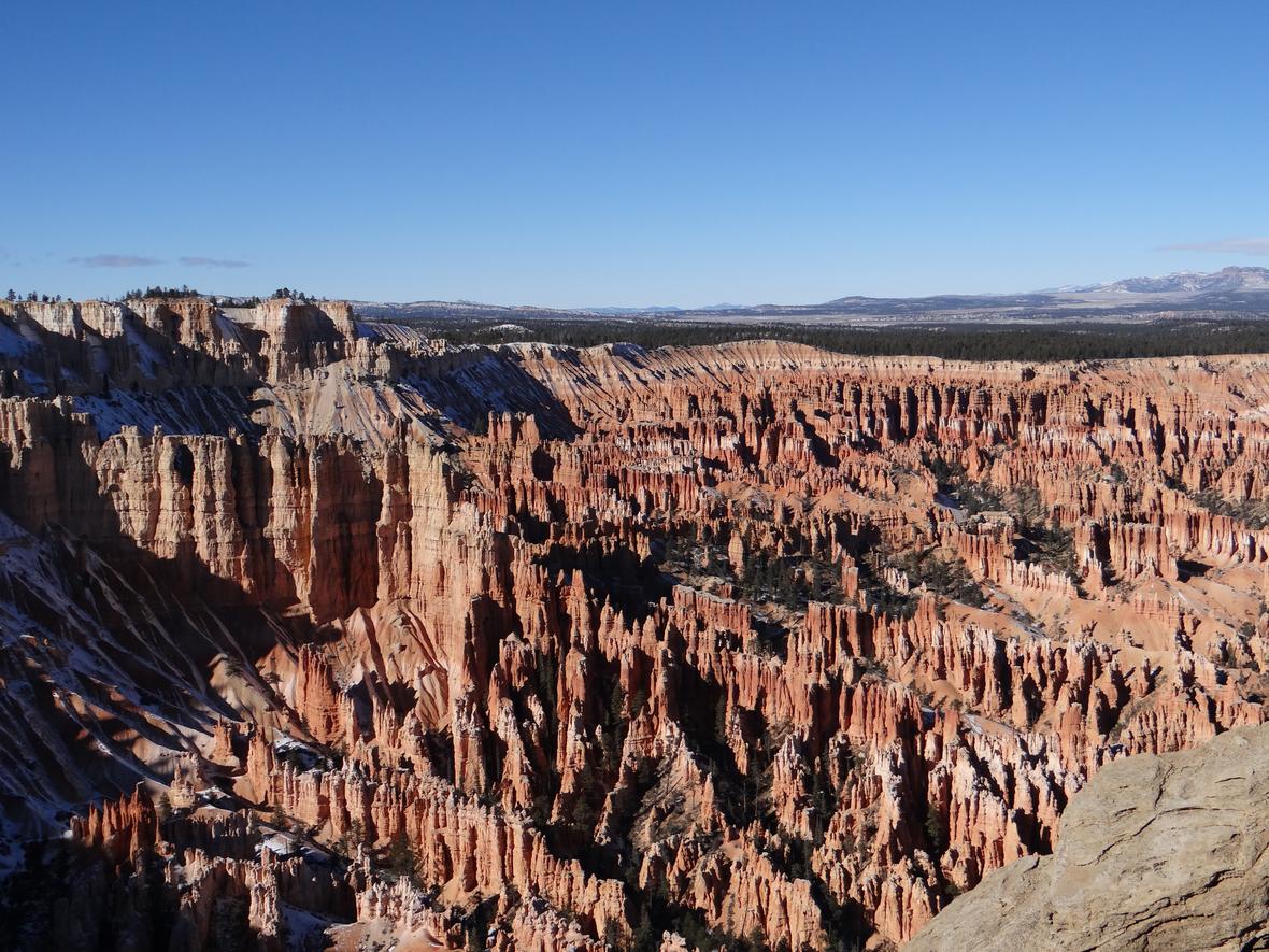
Bryce Canyon amphitheater hoodoos U.S.G.S A. Demas December 17, 2014
https://www.usgs.gov/media/images/ bryce-canyon-amphitheater-hoodoos CC BY-SA 2.0
amphitheater
a level area surrounded by upward sloping ground
andesite
a dark, fine-grained, brown or grayish volcanic rock that is intermediate in composition between rhyolite and basalt
aneroid barometer
device for measuring atmospheric pressure without the use of fluids. It consists of a partially evacuated metal chamber,
the thin corrugated lid of which is displaced by variations in the external air pressure
angular unconformity
landform structure created by deposition, uplift, erosion and renewed deposition
anhydrous
refers to substances that do not contain water
anion
a negatively charged ion
antecedent river
a river whose path of flow within a valley was established before the mountainous structure was uplifted
anthropogenic
related to human activity
anticline
a ridge-shaped fold of stratified rock in which the strata slope downward from the crest, often dome-shaped
aphanitic
name given to certain igneous rocks that are so fine-grained that their component mineral crystals are not detectable by the unaided eye
aqueous
of or containing water, typically as a solvent
arable
used or suitable for growing crops
Aragonite is Fluorescent H. Zell August 2, 2013 Wikipedia Aragonite
https://en.wikipedia.org/wiki/Aragonite#/ media/File:Aragonit_-_Fluorescence.gif CC By-SA 3.0
aragonite
a mineral consisting of calcium carbonate, typically occurring in white seashells and as colorless prisms in deposits in hot springs
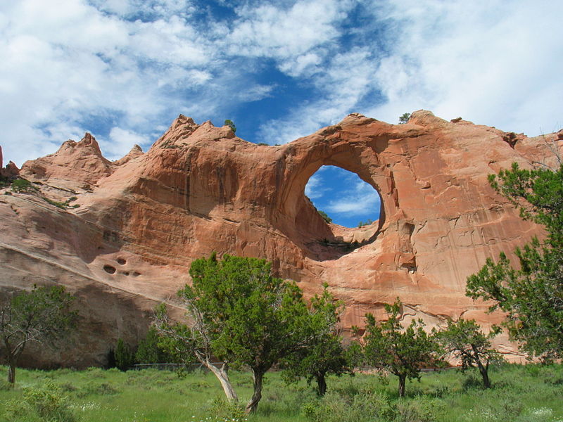
arch
a horizontal geologic structure formed by weathering processes, rather than flowing water, that cut through rock to create a large opening
argillaceous
consisting of or containing clay
atmosphere
the layer of gases surrounding a planet or moon
atom
a basic unit of a chemical element
atomic number
the number of protons in the nucleus of an atom, which determines the chemical properties of an element and its place in the periodic table
B ↑
badland
extensive tracts of heavily eroded, uncultivable land with little vegetation
barometric
relating to measurement of atmospheric pressure
Basalt, a Fine-Grained Igneous Rock January 8, 2005
https://en.wikipedia.org/wiki/Basalt#/ media/File:BasaltUSGOV.jpg public domain
basalt
a dark, fine-grained volcanic rock that sometimes displays a columnar structure, typically composed largely of plagioclase with pyroxene and olivine
base
a chemical species that donates electrons, accepts protons, or releases hydroxide ions in aqueous solution
base level
lowest level to which running water can flow and erode
batholith
a large mass of intrusive igneous rock larger than 100 square kilometers that forms from cooled magma deep in Earth's crust
bedding plane
the surface that separates each successive layer of a stratified rock from its preceding layer
bench
a flat narrow platform of land
bentonite
clay generated from the alteration of volcanic ash, consisting predominantly of smectite minerals, usually montmorillonite
biosphere
the regions of the surface, atmosphere, and hydrosphere occupied by living organisms
biotite
a silicate mineral also called black mica, abundant in metamorphic rocks, in pegmatites, granites and other intrusive igneous rocks
breccia
a rock made of cemented, angular fragments
bridge
a horizontal geologic structure formed by flowing water that cut through rock to create a large opening
Factory Butte, Utah J. Menard Sep. 17, 2008 Wikipedia Factory Butte
https://en.wikipedia.org/wiki/Factory_Butte#/ media/File:Scenery_north_of_Hanksville,_Utah.jpg CC BY-SA 2.0
butte
a hill that rises abruptly from the surrounding area and has sloping or vertical sides and a flat top
C ↑
calcite
a white or colorless mineral consisting of calcium carbonate, a major component of sedimentary rocks such as
limestone, marble, and chalk, can occur in crystalline form and may be deposited in caves to form stalactites and stalagmites
calcium
the chemical element of atomic number 20, a soft gray metal
calcium carbonate
a white insoluble solid occurring naturally as chalk, limestone, marble, and calcite, and forming mollusk shells and stony corals
capillary attraction
the tendency of a liquid in a narrow tube to rise as a result of surface forces
carbonate
a salt of the anion CO32-, typically by reaction with carbon dioxide
carbonic acid
a very weak acid formed in solution when carbon dioxide dissolves in water, its chemical formula is H2CO3
Carboniferous
a geologic period and system that spans 60 million years from the end of the Devonian Period 358.9 million years ago, to the beginning of the Permian Period, 298.9 million years ago,
famous for its vast swamp forests
carrying capacity
threshold level of water resources at which an environment is capable of supporting human activities
castellated
having structures similar to the battlements on a castle
cation
a positively charged ion
Temperature scale comparisons
Community College Consortium for Bioscience Credentials July 7, 2014 Wikimedia Commons Temperature Scale Diagram
https://commons.wikimedia.org/wiki/ File:Temperature-Scale_diagram.jpg CC BY-3.0
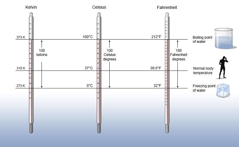
Celsius
temperature scale where the freezing point of water is represented by 0oC and the boiling point of water is represented by 100oC, equivalent to the centigrade temperature scale
Cenozoic
began about 65 million years ago and continues into the present, is the third documented era in the history of Earth
centigrade
temperature scale where the freezing point of water is represented by 0oC and the boiling point of water is represented by 100oC, equivalent to the Celsius temperature scale
chalk
a soft white limestone formed from the skeletal remains of sea creatures
chloride
a compound of chlorine with another element or group, especially a salt of the anion Cl-
chlorite
name of a group of common sheet silicate minerals that form during the early stages of metamorphism
chromosome
a threadlike structure of nucleic acids and protein found in the nucleus of most living cells, carrying genetic information in the form of genes
Ice Springs Cinder Cone and lava flow erupted
720 years ago in the Black Rock Desert Volcanic Field R. Johnson U.S.G.S
https://www.usgs.gov/media/images/ ice-springs-cinder-cone-and-lava-flow- erupted-720-years-ago public domain
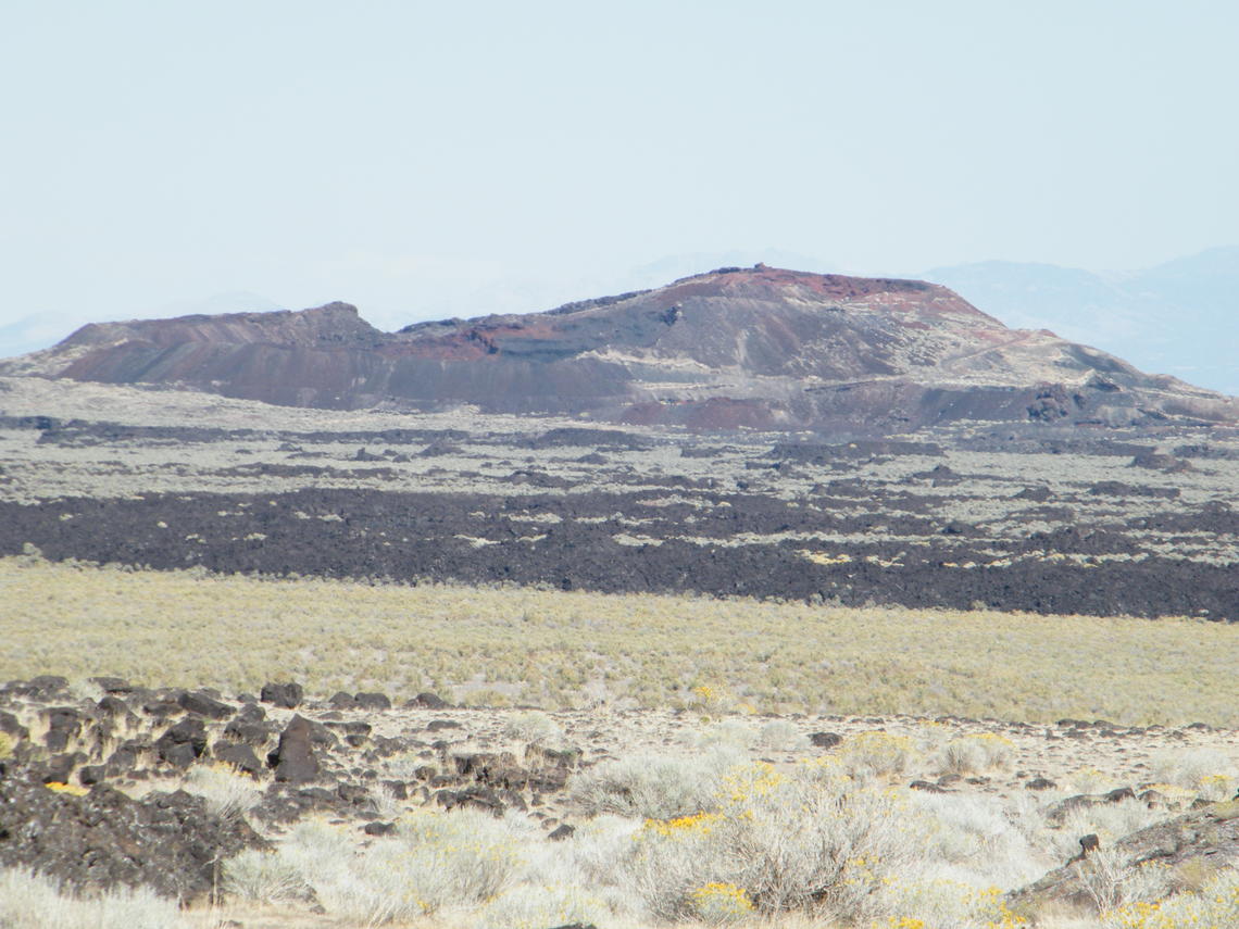
cinder cone
a cone formed around a volcanic vent by fragments of lava thrown out during eruptions
clast
fragment of geological detritus, chunks and smaller grains of rock broken off other rocks by physical weathering
clay
stiff, sticky fine-grained earth, typically yellow, red, or bluish-gray in color and often forming an impermeable layer in the soil
cliff
a steep rock face, especially near a body of water
climate
weather conditions prevailing in an area in general or over a long period of time
compound
a molecule composed of two or more different elements
condenser
something that converts a gaseous substance into a liquid substance through cooling
condensation
conversion of a vapor or gas to a liquid
confluent
flowing together or merging
Conglomerate at the Base of the Cambrian in the Black Hills, South Dakota
M. A. Wilson May 31, 2008 public domain
conglomerate
a coarse-grained clastic sedimentary rock that is composed of a substantial fraction of rounded to subangular gravel-size clasts larger than 2 millimeters in diameter
contraction
shrinkage resulting from cooling
covalent
relating to chemical bonds formed by the sharing of electrons between atoms
crag
a steep or rugged cliff or rock face
Cretaceous
the last period of the Mesozoic era, between the Jurassic and Tertiary periods
cryosphere
portions of a planet's surface where water is solid, including sea ice, lake ice, river ice, snow cover, glaciers, ice caps, ice sheets, and frozen ground
cultivation
preparing soil for crop planting
D ↑
dacite
a volcanic rock resembling andesite but containing free quartz
debouching
emerging from a narrow or confined space into a wide, open area
decomposition
the separation of a substance into simpler substances or basic elements
delta
triangular tract of sediment deposited at the mouth of a river, typically where it diverges into several outlets
deposition (chemistry)
transition of a substance directly from the gas to the solid phase, without passing through the intermediate liquid phase
deposition (geology)
process in which sediments, soil and rocks are added to existing layers of sediments, soil or rock
detritus
gravel, sand, silt, or other material produced by erosion or organic matter produced by the decomposition of organisms
Devonian
a geologic period of the Paleozoic, spanning 60 million years from the end of the Silurian, 419.2 million years ago, to the beginning of the Carboniferous, 358.9 million years ago
diabase
igneous rock also called dolerite
dihydrogen monoxide
chemical name for water
A Dike to the Left of the Red Notebook in the Chinle Formation in Canyonlands National Park J. Stuby May 8, 2002 Wikipedia Dike
https://en.wikipedia.org/wiki/Dike_(geology)#/ media/File:Clastic_dike_UT.jpg public domain
dike
body of igneous rock that cuts across the structure of adjoining rock, usually as a result of the intrusion of magma
dilation
a change in volume due to distortion
diorite
an intrusive igneous rock composed principally of the silicate minerals plagioclase feldspar, biotite, hornblende, and/or pyroxene
disconformity
an unconformity between parallel layers of sedimentary rocks which represents a period of erosion or non-deposition
DNA
deoxyribonucleic acid, a self-replicating material present in nearly all living organisms as the main constituent of chromosomes, carrier of genetic information.
dolerite
a fine- to medium-grained, dark gray to black intrusive igneous rock
down-cutting
water flow that deepens a channel of a stream or valley by removing material from the stream's bed or the valley's floor
E ↑
eclogite
a metamorphic rock consisting of pyroxene omphacite and pyrope-rich garnet
elastic
relating to a substance that can spontaneously return to its normal shape after contraction, dilatation, or distortion
electrochemistry
the branch of chemistry that deals with the relations between electrical and chemical phenomena
electron
a negatively-charged subatomic particle that orbits atomic nuclei
element
each of more than one hundred substances that cannot be chemically converted or broken down into simpler substances and which are primary constituents of matter
elevation
height above a given level, especially sea level
equilibrium
a state in which opposing forces or influences are balanced
escarpment
long, steep slope, especially one at the edge of a plateau or separating areas of land at different heights
evaporation
process of turning from liquid into vapor
extravasated
let or force out from the vessel that naturally contains it into the surrounding area
extrusive
refers to igneous volcanic rock in which hot magma from inside the Earth flows out onto the surface as lava or explodes violently into the atmosphere to fall back as
pyroclastics or tuff
F ↑
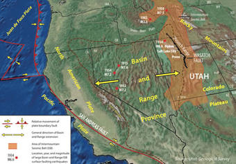
Wasatch Fault Located in Central Utah and Southeast Idaho Along Eastern Edge of Basin and Range Province
U.S.G.S https://www.usgs.gov/natural-hazards/
earthquake-hazards/science/how-big-and -how-frequent-are-earthquakes-wasatch-fault? qt-science_center_objects=0#qt-science_center_objects public domain
fault
crack in the Earth's crust often associated with boundaries between Earth's tectonic plates
fauna
the animals of a particular region, habitat, or geological period
feldspar
an abundant seimentary mineral typically occurring as colorless or pale-colored crystals and consisting of aluminosilicates of potassium, sodium, and calcium
felsic
refers to igneous rocks that are relatively rich in elements that form feldspar and quartz
ferromagnesian
referring to a rock or mineral containing iron and magnesium as major components
fin
a narrow, residual wall of hard sedimentary rock that remains standing after surrounding rock has been eroded away along parallel joints or fractures
fissure
a long, narrow opening or line of breakage made by cracking or splitting in rock or earth
flora
the plants of a particular region, habitat, or geological period
fold
when originally flat, level surfaces, such as sedimentary strata, are bent or curved as a result of pressure and high temperature
foliated
the parallel arrangement of certain mineral grains that gives the rock a striped appearance
fossiliferous
refers to rock containing many fossils
freshet
flood of a river from heavy rain or melted snow
frost wedging
weathering that occurs as a result of repeated freezing and thawing of water in areas with extremely cold weather
G ↑
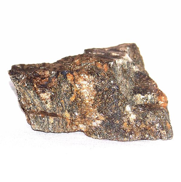
Gabbro July 22, 2014 Mars.NASA.gov Wikipedia Gabbro
public domain
gabbro
a dense, mafic intrusive rock generally occurring as batholiths and laccoliths and often found along mid-ocean ridges or in ancient mountains composed
of compressed and uplifted oceanic crust
garnet
a large group of rock-forming minerals with a common crystal structure and a generalized chemical composition of X3Y2(SiO4)3
gene
the basic physical and functional unit of heredity
geochronology
the branch of geology concerned with the dating of rock formations and geological events
geodetic
relating to land surveying
geology
the science that deals with Earth's physical structure and substance, its history, and the processes that act on it
gneiss
common type of metamorphic rock formed by high temperature and high-pressure
gorge
narrow valley between hills or mountains, typically with steep rocky walls and a stream running through it
gradation
a scale or a series of successive changes, stages, or degrees
gradientor
micrometer attachment that measures the elevation of the telescope with great precision
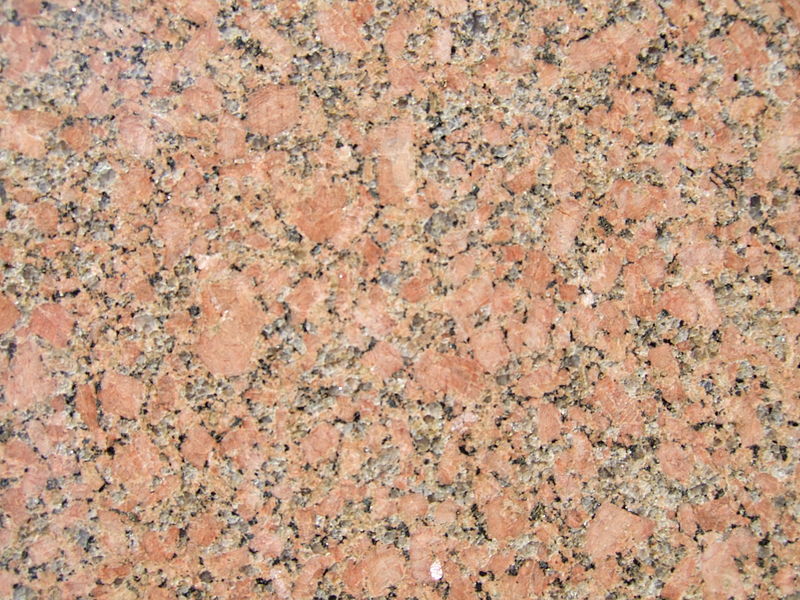
Granite July 16, 2007 Friman Wikipedia Granite CC BY-SA 3.0
granite
formed from the slow crystallization of magma below Earth's surface, a light-colored igneous rock composed mainly of quartz and feldspar with minor amounts of
mica, amphiboles, and other minerals with grains large enough to be visible with the unaided eye
graupel
precipitation that forms when supercooled water droplets are collected and freeze on falling snowflakes, forming 2 to 5 millimeter balls of rime
gravel
loose aggregation of rock fragments, classified by particle size range and includes size classes from granule- to boulder-sized fragments
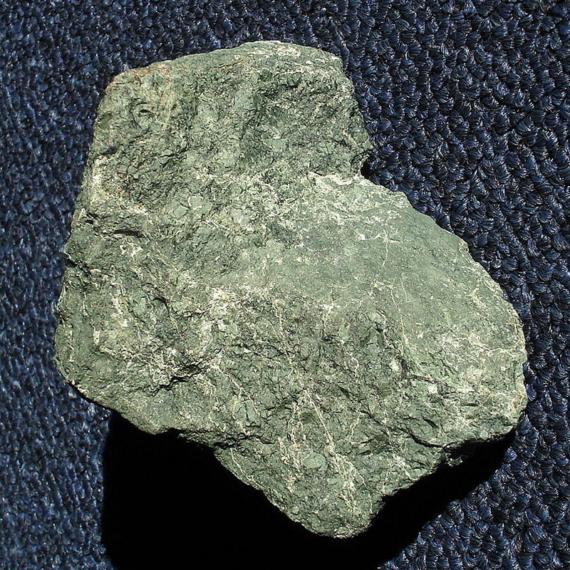
greenstone
rock formed when mafic minerals which make basalt black are commonly changed into a green mineral called chlorite as they are exposed to surface weathering processes
gypsum
a soft white or gray mineral consisting of hydrated calcium sulfate which occurs chiefly in sedimentary deposits
H ↑
helictite
a distorted form of stalactite that resembles a twig
hoodoo
a column or pinnacle of weathered rock
hornblende
a dark brown, black, or green mineral of the amphibole group consisting of a hydroxyl alumino-silicate of calcium, magnesium, and iron, occurring
in many igneous and metamorphic rocks
Hornfels
P. Sosnowski May 3, 2009 Wikipedia Hornfels https://commons.wikimedia.org/wiki/File:Hornfels_4.JPG CC BY-SA 4.0
hornfels
a metamorphic rock formed by the contact between mudstone and shale, or other clay-rich rock, and a hot igneous body,
representing a heat-altered equivalent of the original rock
hot spot
volcanic regions that are not found at the edges of continents or faults
humidity
concentration of water vapour present in the air
humus
the organic component of soil, formed by the decomposition of leaves and other plant material by soil microorganisms
hydrated
chemically combined with water
hydrogen
a colorless, odorless, highly flammable gas, the chemical element of atomic number 1
hydrography
the science of surveying and charting bodies of water, such as seas, lakes, and rivers
hydrology
the science concerned with the properties of Earth's water, and especially its movement in relation to land
hydrosphere
the combined mass of water found on, under, and above Earth's surface
hydrostatic pressure
the pressure exerted by a fluid at equilibrium at a given point within the fluid, due to the force of gravity
hydrous
refers to substances containing water
hydroxide
a compound of a metal with the hydroxide ion OH- or the group -OH
hydroxyl
of or denoting the radical -OH, present in alcohols and many other organic compounds
hypsometric
relating to the measurement of heights
I ↑
Components of Igneous Rock J. Johnson
U.S.G.S public domain
igneous
rock formed through the cooling and solidification of magma or lava
impervious
not allowing fluid to pass through
incrustation
the action of encrusting or state of being encrusted
indurated
made hard like rock
inosilicate
silicate with interlocking chains of silicate tetrahedra
insoluble
refers to a substance that cannot be dissolved
intrusive
also called plutonic rock, igneous rock formed from magma forced into older rocks at depths within the Earth's crust, which then slowly solidifies below the Earth's surface
ion
an atom or molecule with a net electric charge due to the loss or gain of one or more electrons
iron
a strong, hard magnetic silvery-gray metal, the chemical element of atomic number 26, much used as a material for construction and manufacturing, especially in the form of steel
irrigable
capable of being watered
irrigation
the supply of water to land or crops to help growth, typically by means of channels
isohyetal
line on a map connecting places which have an equal annual rainfall
J ↑
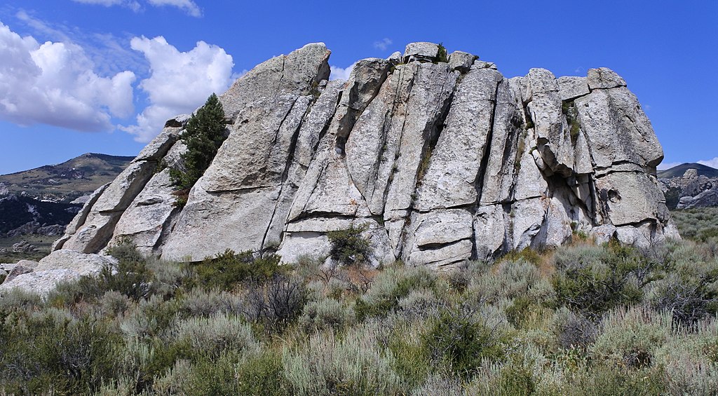
Joints in the Almo Pluton, City of Rocks National Reserve, Idaho M. A. Wilson July 26, 2017
Wikipedia Joint (geology) https://en.wikipedia.org/wiki/Joint_(geology)# /media/File:Joints_City_of_Rocks_NR.jpg CC0
joint
a fracture dividing rock into two sections that moved away from each other
Jurassic
a geologic period that spanned 56 million years from the end of the Triassic Period 201.3 million years ago to the beginning of the Cretaceous Period 145 million years ago
K ↑
Kelvin
temperature scale where 0oC is equal to 273.15K and 100oC is equal to 373.15K
L ↑
laccolith
a lens-shaped mass of igneous rock, that has been intruded between rock strata causing a dome-shaped uplift
latent heat of evaporation
amount of heat required to convert a specific amount of a substance from a liquid to a gas
latent heat of fusion
amount of heat required to convert a specific amount of a substance from a solid to a liquid
lava
molten rock erupted from a volcano or fissure, or solid rock resulting from an eruption
leach
drain away from soil, ash, or similar material by the action of percolating liquid, especially rainwater
lepidolite
a lilac-gray or rose-colored member of the mica group of minerals
lime
a white caustic alkaline substance consisting of calcium oxide, which is obtained by heating limestone and which combines with water with the production of much hea
Ooids in Limestone of the Middle Jurassic Carmel Formation in Southwestern Utah
M. A. Wilson May 17, 2018 Wikipedia Limestone
https://en.wikipedia.org/wiki/Limestone#/ media/File:Ooids_Carmel_Formation_Jurassic.jpg CC0
limestone
hard sedimentary rock, composed mainly of calcium carbonate or dolomite, used as building material and in the making of cement
lithosphere
the rigid outer part of the Earth, consisting of the crust and upper mantle
lixiviation
the process of separating soluble from insoluble substances by dissolving the former in water or some other solvent
loam
a fertile soil of clay and sand containing humus
M ↑
mafic
relating to a group of dark-colored, mainly ferromagnesian minerals such as pyroxene and olivine
magma
hot fluid material below or within Earth's crust from which lava and other igneous rock is formed after cooling
magnesia
a hydrated magnesium carbonate
magnesium
the chemical element of atomic number 12, a silver-white metal of the alkaline earth series. It is used to make strong lightweight alloys
Mesas near Spring Canyon, Green River U.S. Bureau of Land Management
http://www.publicdomainfiles.com/ show_file.php?id=13938778815668 public domain
mantle
a layer inside a planetary body bounded below by a core and above by a crust
marble
a metamorphic rock formed from sedimentary carbonate rocks, most commonly limestone or dolomite
mechanics
the branch of physics involving motion and the forces that produce it
mercurial barometer
instrument used for measuring change in atmospheric pressure
mercury
a chemical element with the symbol Hg and atomic number 80, commonly known as quicksilver
mesa
an isolated flat-topped hill with steep sides, found in landscapes with horizontal strata
Mesozoic
relating to or denoting the era between the Paleozoic and Cenozoic eras, comprising the Triassic, Jurassic, and Cretaceous periods
Metamorphic Mississippian Marble in Big Cottonwood Canyon, Wasatch Mountains
M. A. Wilson June 30, 208 public domain
metamorphic
relating to rock that has undergone transformation by heat, pressure, or other natural processes
mica
a shiny silicate mineral with a layered structure, found as minute scales in granite and other rocks, or as crystals
migmatite
a composite rock found in medium and high-grade metamorphic environments
mineral
substance occurring in nature usually comprising inorganic materials s of definite chemical composition and definite crystal structure,
may include organic substances such as coal
molecular polarity
a separation of electric charge in a molecule that results in a negatively charged end and a positively charged end
molecule
a group of atoms bonded together, representing the smallest fundamental unit of a chemical compound that can take part in a chemical reaction
monoclinal ridge
top of a step-like fold in rock strata consisting of a zone of steeper dip within an otherwise horizontal or gently-dipping sequence
Grandview-Phantom Monocline in the Grand Canyon J. Stuby May 20, 2009
Wikipedia Monocline https://en.wikipedia.org/wiki/Monocline#/media/ File:Grandview-Phantom_Monocline.jpg public domain
monocline
a bend in rock strata that are otherwise uniformly dipping or horizontal
montmorillonite
an aluminum-rich clay mineral of the smectite group, containing some sodium and magnesium
N ↑
nepheline
a silica-undersaturated aluminosilicate that occurs in intrusive and volcanic rocks with low silica, and in their associated pegmatites
neutron
a neutrally-charged subatomic particle in atomic nuclei
nickel
a silvery-white metal, the chemical element of atomic number 28
nitrogenous
refers to a substance containing nitrogen
nonconformity
exists between sedimentary rocks and metamorphic or igneous rocks when the sedimentary rock lies above and
was deposited on the pre-existing and eroded metamorphic or igneous rock
nucleic acid
a complex organic substance present in living cells, especially DNA or RNA, whose molecules consist of many nucleotides linked in a long chain
nucleoside
a compound commonly found in DNA or RNA
nucleotide
a compound consisting of a nucleoside linked to a phosphate group, forms the basic structural unit of nucleic acids such as DNA
O ↑
obsidian
a naturally occurring volcanic glass formed as an extrusive igneous rock, produced when felsic lava extruded from a volcano cools rapidly with minimal crystal growth
Arizona Basalt with Olivine Crystals V. Smith July 27, 2005 Wikipedia Olivine
https://en.wikipedia.org/wiki/Olivine#/ media/File:Peridot_in_basalt.jpg CC By-SA 3.0
olivine
an olive-green, gray-green, or brown silicate mineral occurring widely in basalt, peridotite, and other basic igneous rocks
omphacite
a member of the pyroxene group of silicate minerals with formula (Ca, Na)(Mg, Fe2+, Al)Si2O6
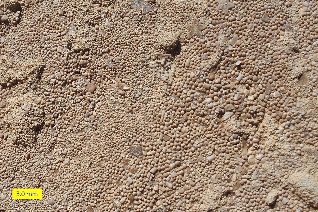
ooid
small, spheroidal, coated sedimentary grains, usually composed of calcium carbonate, sometimes of iron- or phosphate-based minerals, usually form on the sea floor,
most commonly in shallow tropical seas
organic
produced or involving production without the use of chemical fertilizers, pesticides, or other artificial substances
orogeny
a process by which Earth's crust is folded and deformed, creating mountains
orograph
machine used in making topographical maps that is operated by being pushed across country and that records both distances and elevations
oxidizing
chemically combining with oxygen
oxygen
a colorless, odorless reactive gas, the chemical element of atomic number 8 and the life-supporting component of the air
P ↑
paleontologist
a scientist who studies fossils
Paleozoic
relating to or denoting the era between the Precambrian eon and the Mesozoic era
Pegmatite Containing Lepidolite, Tourmaline, and Quartz from the White Elephant Mine
in the Black Hills, South Dakota J. Stuby April 16, 2007
Wikipedia Pegmatite https://en.wikipedia.org/wiki/Pegmatite#/ media/File:We-pegmatite.jpg public domain
paraconformity
strata on either side of the unconformity are parallel, there is little apparent erosion
pegmatite
a coarsely crystalline granite or other igneous rock with crystals several centimeters to several meters in length
percolation
process of a liquid slowly passing through a filter or the ground
perennial
present all seasons of the year
peridotite
a dense, coarse-grained plutonic rock containing a large amount of olivine, believed to be the main constituent of Earth's mantle
permeable
a material that allows liquids or gases to pass through it
Permian
a geologic period which spans 47 million years from the end of the Carboniferous period 298.9 million years ago to the beginning of the Triassic period 251.902 million years ago,
it is the last period of the Paleozoic era
pH
a figure expressing the acidity or alkalinity of a solution on a logarithmic scale on which 7 is neutral, lower values are more acid and higher values more alkaline
phosphate group
a molecule containing one atom of phosphorus covalently bound to four oxygen residues
phyllite
a type of foliated metamorphic rock created from slate further metamorphosed so that very fine grained white mica achieves a preferred orientation
pinnacle
a high, pointed piece of rock
Plagioclase U.S.G.S. January 7, 2005
Wikipedia Plagioclase public domain
plagioclase
a typically white form of feldspar consisting of aluminosilicates of sodium or calcium, common in igneous rocks
plateau
area of relatively level high ground
plutonic
refers to intrusive igneous rock that forms when magma is trapped deep inside the Earth
polymer
a substance made of similar molecular chains bonded together
porphyritic
denoting a rock texture, typically found in volcanic rocks, containing distinct crystalline particles
porous
rock having minute spaces or holes through which liquid or air may pass
potash
an alkaline potassium compound, especially potassium carbonate or hydroxide
potassium
the chemical element of atomic number 19, a soft silvery-white reactive metal of the alkali metal group
Precambrian
the earliest part of Earth's history, set before the current Phanerozoic Eon
precipitation
any product of the condensation of atmospheric water vapor that falls under gravity, includes drizzle, rain, sleet, snow, graupel and hail
protein
nitrogenous organic compounds that consist of large molecules composed of one or more long chains of amino acids and are an essential part of all living organisms
A Geologist Explores a Pyroclastic Flow from Mt. St. Helens D. A. Swanson
May 29, 1980 U.S.G.S Wikipedia Pyroclastic Rock
public domain
proton
a positively-charged subatomic particle in atomic nuclei
pyroclastic
relating to, consisting of, or denoting fragments of rock erupted by a volcano
pyroxene
a large class of rock-forming silicate minerals, generally containing calcium, magnesium, and iron and typically occurring as prismatic crystals
pyrope
the most well-known gemstone form of garnet
Q ↑
quartz
a hard white or colorless mineral consisting of silicon dioxide, found widely in igneous, metamorphic, and sedimentary rocks
quartzite
a hard, non-foliated metamorphic rock which was originally pure quartz sandstone
R ↑
radical
a group of atoms behaving as a unit in a number of compounds
radioactivity
emission of particles caused by the spontaneous disintegration of atomic nuclei
rarefaction
relating to the spreading of gas particles
ravine
a deep, narrow gorge with steep sides
remunerative
referring to something that is profitable
reservoir
a large natural or artificial lake used as a source of water supply
resonance
the reinforcement or prolongation of sound by reflection from a surface or by the synchronous vibration of a neighboring object
Rhyolite
M. C. Rygel February 11, 2014 Wikipedia Rhyolite
https://en.wikipedia.org/wiki/Rhyolite#/ media/File:PinkRhyolite.tif CC BY-SA 3.0
rhyolite
an extrusive igneous rock with a very high silica content, usually pink or gray in color with grains so small that they are difficult to observe without a hand lens,
made up of quartz, plagioclase, and sanidine, with minor amounts of hornblende and biotite
ridge
a long narrow hilltop, mountain range, or watershed
rill
a small stream
rime
frost formed on cold objects by the rapid freezing of water vapor in cloud or fog
riparian
relating to wetlands adjacent to rivers and streams
rivulet
avery small stream
RNA
ribonucleic acid, a polymeric molecule essential in various biological roles in coding, decoding, regulation and expression of genes
rock
any naturally occurring solid mass or aggregate of minerals
S ↑
sagebrush
a shrubby aromatic North American plant of the daisy family
saline
containing salt
salt
any chemical compound formed from the reaction of an acid with a base, with all or part of the hydrogen of the acid replaced by a metal or other cation
San Rafael Reef Sandstone G. Thomas May 7, 2006 Wikipedia San Rafael Reef
https://en.wikipedia.org/wiki/Navajo_Sandstone#/ media/File:SanRafaelReefUT.jpg public domain
sandstone
sedimentary rock composed of sand-size grains of mineral, rock, or organic material
schist
coarse-grained metamorphic rock which consists of layers of different minerals and can be split into thin irregular plates
scoria
a highly vesicular, dark colored volcanic rock that may or may not contain crystals
second-foot
a continuous flow of one cubic foot of water per second
sediment
any particulate matter that can be transported by fluid flow and which eventually is deposited as a layer of solid particles on the bed or bottom of a body of water or other liquid
sedimentary
relating to solid particles or rocks deposited in bodies of water
seismic
relating to earthquakes or other vibrations of the Earth and its crust
selenite
a form of gypsum occurring as transparent crystals, sometimes in thin plates
Serpentinite from Golden Gate Recreation Area E. Zimbres June 30, 2010 Wikipedia Serpentinite CC BY-SA 3.0
serpentinite
a metamorphic rock that is mostly composed of ultramific rocks that have undergone hydrous alteration
shadescale
a small shrub with woody, thorny branches and leaves with a whitish, scale-like coating
shale
soft, finely stratified sedimentary rock that formed from consolidated mud or clay and can be split easily into fragile slabs
silicate
a salt in which the anion contains both silicon and oxygen, especially one of the anion SiO42-
silt
fine sand, clay, or other material carried by running water and deposited as a sediment
slate
a fine-grained, foliated, homogeneous metamorphic rock derived from an original shale-type sedimentary rock composed of clay or volcanic ash through low-grade regional metamorphism
slump
created when a mass of loosely consolidated materials or a rock layer moves a short distance down a slope
smectite
hydrous aluminum silicates containing iron and magnesium as well as either sodium or calcium
soda
sodium carbonate, especially as a natural mineral or as an industrial chemical
sodium
the chemical element of atomic number 11, a soft silver-white reactive metal of the alkali metal group
soil
upper layer of earth in which plants grow, a black or dark brown material typically consisting of a mixture of
organic remains, clay, and rock particles
soluble
able to be dissolved, especially in water
solution
a liquid mixture in which the minor component referred to as the solute is uniformly distributed within the major component referred to as the solvent
solvent
a substance able to dissolve other substances
specific heat
the amount of energy required to change the temperature of a substance
spirit level
an instrument designed to indicate whether a surface is horizontal or vertical
spring
natural flow of water from the ground or from rocks, representing an outlet for the water that has accumulated in permeable rock strata underground
Stalactites at Timpanogos Cave
National Park Service October 16, 2019 Timpagonos Cave: Captivating Canyon Caves
https://www.nps.gov/tica/index.htm public doamain
stalactite
a tapering structure hanging from the roof of a cave, formed of calcium salts deposited by dripping water
stalagmite
a mound or tapering column rising from the floor of a cave, formed of calcium salts deposited by dripping water and often uniting with a stalactite
stoma
minute pores in the epidermis of the leaf or stem of a plant, forming a slit of variable width which allows movement of gases in and out of the intercellular spaces
strata
layers of sedimentary rock or soil, or igneous rock that was formed at the Earth's surface, with internally consistent characteristics that distinguish it from other layers
subaerial
existing, occurring, or formed in the open air or on the earth's surface, not underwater or underground
subaerial erosion
refer to the processes of weathering and mass movement
sublimation
transition of a substance directly from the solid to the gas phase, without passing through the intermediate liquid phase
sulfate
a salt of sulfuric acid, containing the anion SO42-
sulfuric acid
a strong acid made by oxidizing solutions of sulfur dioxide
surface tension
when the surface of a liquid resists intrusion by objects placed on it
sward
upper layer of soil, especially when covered with grass
synchronous
existing or occurring at the same time
synclinal
relating to a folded rock structure in which the sides dip toward a common line or plane
Syncline in Navajo Sandstone, Upheaval Dome, Canyonlands National Park J. Sutby January 23, 2009
Wikipedia Syncline public domain
syncline
a trough or fold of stratified rock in which the strata slope upward from the axis
T ↑
tail water
refers to waters located immediately downstream from a hydraulic structure, such as a dam, bridge or culvert.
temperature
degree or intensity of heat present in a substance or object
terrace
a step-like landform
Tertiary
relating to or denoting the first period of the Cenozoic era, between the Cretaceous and Quaternary periods, and comprising the Paleogene and Neogene subperiods
tetrahedra
a solid having four plane triangular faces, a triangular pyramid
thermodynamics
the branch of science that deals with the relations between heat and other forms of energy
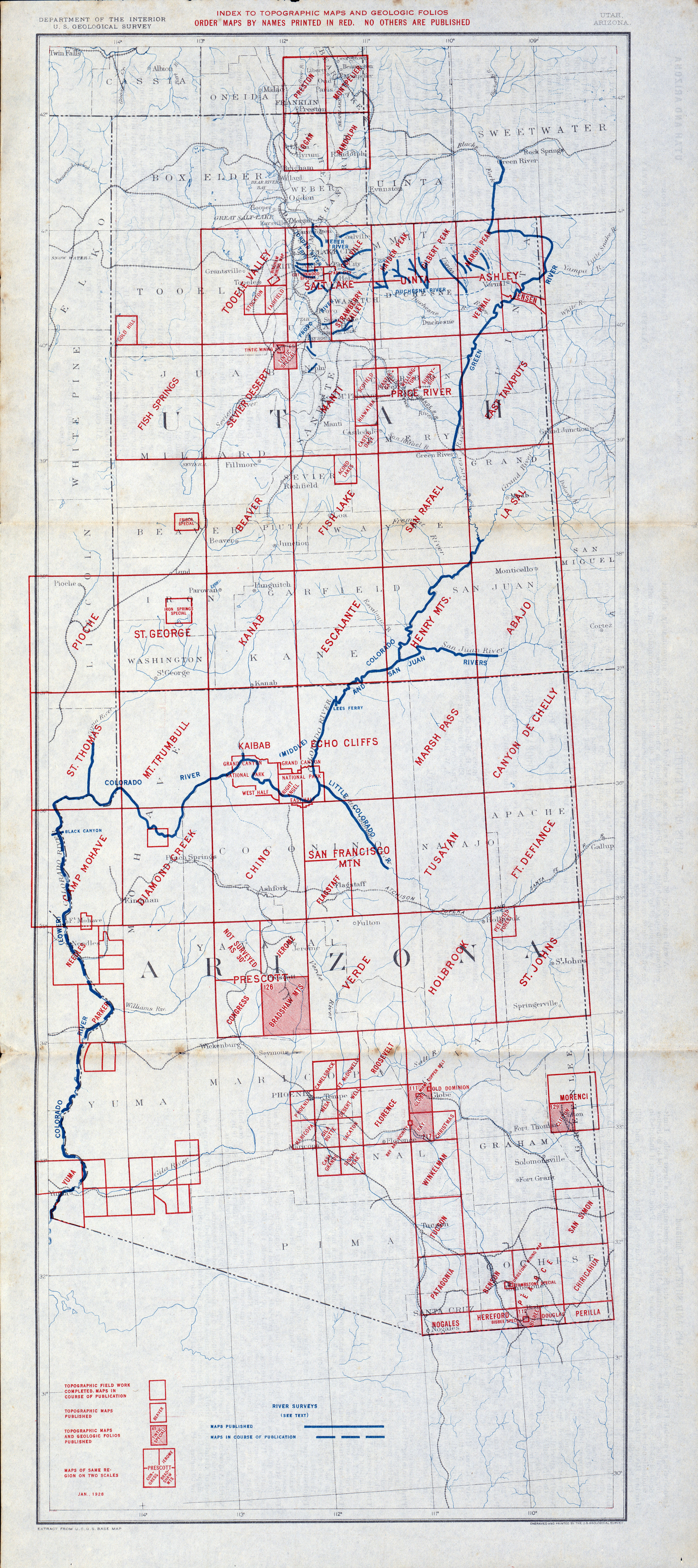
1928 Utah Topographical Map Perry-Castañeda Library Map Collection
http://legacy.lib.utexas.edu/maps/topo/indexes/ txu-pclmaps-topo-ut_az-index-1928.jpg public domain
topography
detailed description or representation on a map of the natural and artificial features of an area
tourmaline
crystalline boron silicate mineral compounded with elements such as aluminium, iron, magnesium, sodium, lithium, or potassium
trachyte
an igneous volcanic rock with an aphanitic to porphyritic texture
transpiration
exhalation of water vapor through the stomata of a plant or leaf
transverse valley
valley which cuts at right angles across a ridge or, in mountainous terrain a valley that generally runs at right angles to the line of the main mountain chain or crest
Triassic
the earliest period of the Mesozoic era, spans 50.6 million years from the end of the Permian Period 251.9 million years ago, to the beginning of the Jurassic Period 201.3 million years ago
tuff
a light, porous rock formed by consolidation of volcanic ash
U ↑
unconformable contact
occurs between two geological units in which the older, underlying rocks dip at an angle different from the younger, overlying strata, usually in which younger sediments rest upon the eroded surface of tilted or folded older rocks
unconformity
geologic gaps in rock formations characterized by missing rock layers where the upper layers are usually much younger than the lower layers
uniformitarianism
the theory that changes in the earth's crust during geological history have resulted from the action of continuous and uniform processes
uplifting
vertical elevation of the Earth's surface in response to natural causes
V ↑
verdure
lush green vegetation
vesicular
refers to rock pitted with many cavities or small holes where gas was trapped during cooling
virus
an infective agent that typically consists of a nucleic acid molecule surrounded by a protein coat, usually too small to be seen by a microscope, and able to multiply only within the living cells of a host
viscous
refers to the measure of resistance of a fluid to deformation under stress
volcanic bomb
a mass of molten rock larger than 64 millimeters in diameter, formed when a volcano ejects viscous fragments of lava during an eruption
W ↑
waterpocket
refers to the potholes that dot sandstone and fill with rainwater
weather
state of the atmosphere at a place and time characterized by wind, humidity, temperature, cloud cover and precipitation
weathering
the breakdown of rocks at the Earth's surface, by the action of rainwater, extremes of temperature, and biological or chemical activity
Window Rock, Arizona B. FrantzDale August 19, 2006 Wikimedia Window Rock
https://commons.wikimedia.org/wiki/File:Window_rock_AZ.jpg
GNU Free Documentation License
window
a structure formed by erosion or normal faulting on a thrust system where the hanging wall block has been transported by movement along a thrust
X ↑
xeriscaping
landscaping requiring little or no irrigation
Y ↑
Z ↑
zoogenic
produced by or originating in animals
zoonotic
relating to diseases that can be transferred from animals
Denise Meeks, dmeeks@email.arizona.edu