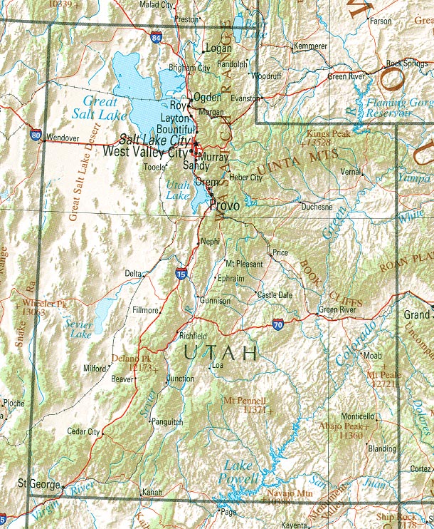
Explore Utah
Utah Map Perry-Castañeda Library, University of Texas Libraries and November 7, 2004 Wikipedia List of Mountain Ranges
https://en.wikipedia.org/wiki/ List_of_mountain_ranges_of_Utah#/media/File:Utah_ref_2001.jpg public domain
Introduction
Utah consists of three primary regions: the Colorado River Basin, which occupies the southeast part of Utah along the Colorado River,
the Great Salt Lake region in the northern part of Utah, and the Great Basin south of the Great Salt Lake region and west of the Colorado River Basin.
The Colorado Plateau is an area of uplifted land located around the Four Corners, where Colorado, Utah, Arizona and New Mexico meet.
The largest sections of the plateau are in Utah and Arizona.
About 60 to 80 million years ago this was a flat, stable formation, then geologic forces began to push the land up, increasing its altitude.
Most of the uplift occurred about 5.5 million years ago, when the plateau rose about 3,000 feet, creating mountains that warped the surrounding landscape.[1]
The National Parks section provides an expandable, clickable Google map of Utah's national parks.
Sources:
[1]
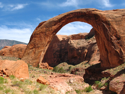
National Park Service. (June 5, 2015). Rainbow Bridge.
https://www.nps.gov/rabr/learn/nature/ geologicformations.htm
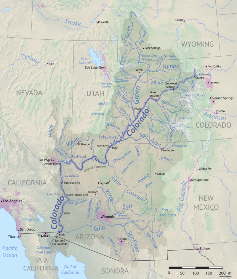
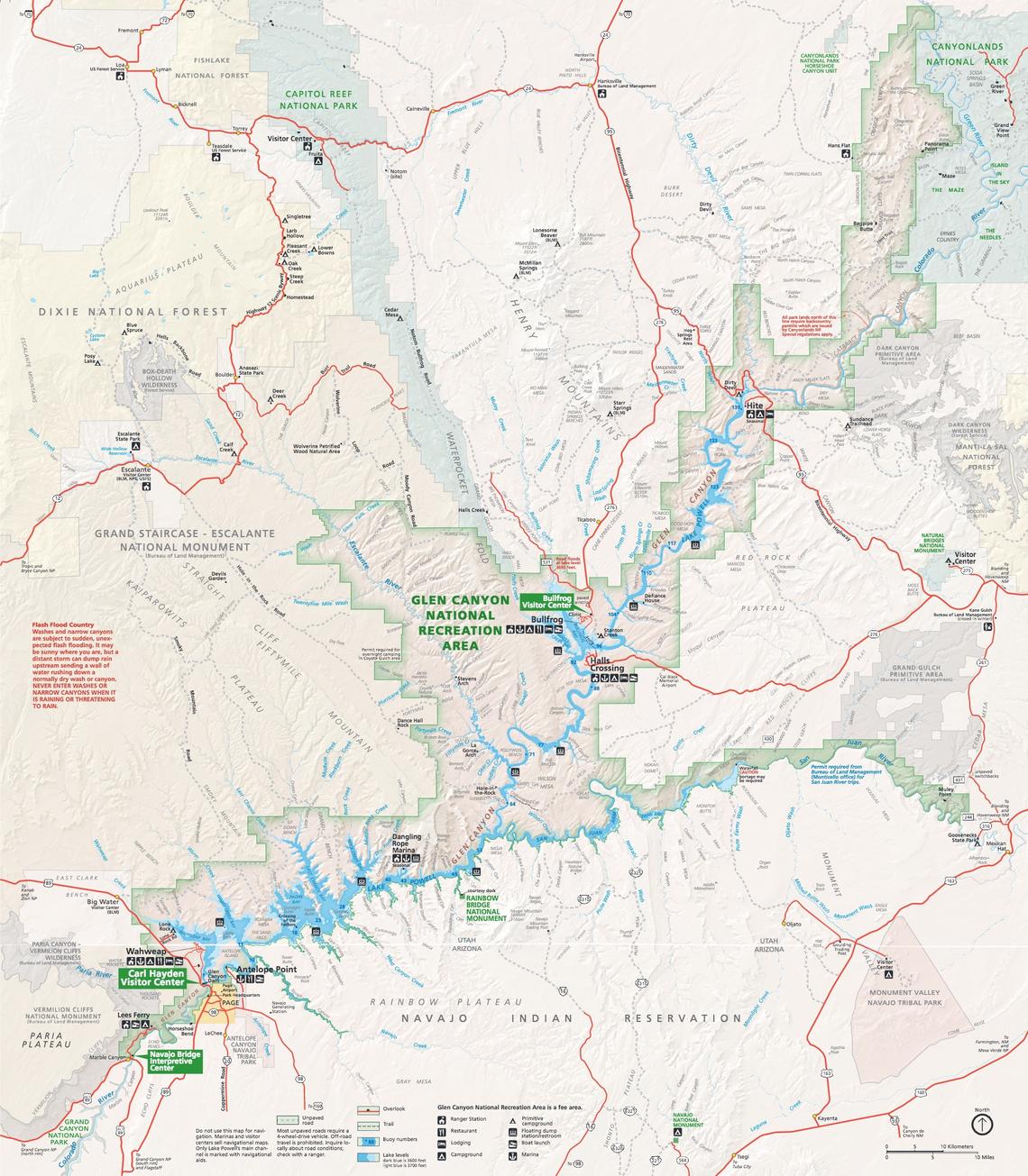
Colorado River Basin
The Colorado River is about 1,450 miles long.
Its headwaters are located in Colorado and Wyoming.
It flows across the international border into Mexico.
The drainage basin area is about 246,000 square miles and includes all of Arizona and parts of California, Colorado, New Mexico, Nevada, Utah, and Wyoming.
[1]
The Colorado River is an important water resource for areas outside of the basin, including Denver, Salt Lake City, Albuquerque, Los Angeles, and San Diego for municipal water,
and the Imperial Valley in California for agricultural water.
The river and its tributaries provide water to the nearly 30 million people, both within and outside of the basin, and it irrigates nearly 4 million acres of agricultural lands.
[1]
Water management is governed by a complex system of international treaties, interstate compacts, and Supreme Court decrees.
The Bureau of Reclamation plays a major role in the control and distribution of surface water within the Colorado River Basin through
management of large Federal water projects like Glen Canyon Dam and Lake Powell and Hoover Dam and Lake Mead.[1]
The major tributaries of the Colorado River (from northeast to southwest) include the Green, Dirty Devil, Escalante, and San Juan Rivers.
The Green River also has several major tributaries (from northeast to southwest) including the Uinta, White, Willow Creek, Price, and San Rafael Rivers.
[2]
The City of Tucson has implemented a water conservation program resulting in a 40-year surplus of recharged groundwater.
Even if Lake Mead's supply drops below critical levels, our city has a Colorado Water Plan to ensure we have sufficient water for our growing population until 2050.
[3]
Sources:
[1]
U.S.G.S. Colorado River Basin Focus Area Study.
https://www.usgs.gov/mission-areas/water-resources/science/colorado-river-basin-focus-area-study?qt-science_center_objects=0#qt-science_center_objects
[2]
Geology.com. Utah Lakes, Rivers and Water Resources.
https://geology.com/lakes-rivers-water/utah.shtml
[3]
American Rivers. Colorado River: Colorado, Wyoming, Utah, New Mexico, Nevada, Arizona, California.
https://www.americanrivers.org/river/colorado-river/
Colorado River Basin Shannon1 January 25, 2018
Wikipedia Colorado River
https://en.wikipedia.org/wiki/Colorado_River#/ media/File:Colorado_River_basin_map.png CC BY-SA 4.0
Colorado River
John Wesley Powell's 1869 expedition made the the 1,450 mile-long river famous.
The sixth largest river in the U.S. begins in Rocky Mountain National Park in Colorado on the Continental Divide where it starts as a small stream.
It grows into an expansive river through gorges and valleys and across plains, ending in the Gulf of California in northwestern Mexico where it
creates 17 miles of the U.S.-Mexico border.[1],[2]
Downstream it runs between the Mojave and the Sonoran Deserts and passes through 11 national parks and monuments, seven states and two countries.
[2]
It provides water for agriculture, industry, and domestic use for cities between Denver and Tijuana and sustains a $1.4 trillion annual economy supported by substantial recreation
that contributes $26 billion.[1]
The Colorado's most beautiful attraction, the Grand Canyon, was recognized as a national monument by President Teddy Roosevelt in 1908 and as a national park in 1919.
On August 19, 1921, Congress approved the Colorado River Compact, an agreement among the states and territories of Arizona, California, Colorado, Nevada, New Mexico,
Utah, and Wyoming.[3]
The Compact was ratified in 1922.[1]
Article I states:
The major purposes of this compact are to provide for the equitable division and apportionment of the use of the waters
of the Colorado River System; to establish the relative importance of different beneficial uses of water, to promote interstate
comity; to remove causes of present and future controversies; and to secure the expeditious agricultural and industrial
development of the Colorado River Basin, the storage of its waters, and the protection of life and property from floods. To
these ends the Colorado River Basin is divided into two Basins, and an apportionment of the use of part of the water of the
Colorado River System is made to each of them with the provision that further equitable apportionments may be made.[3]
Article II defines several important terms:
As used in this compact-
(a) The term "Colorado River System" means that portion of the Colorado River and its tributaries within the United
States of America.
(b) the term "Colorado River Basin" means all of the drainage area of the Colorado River System and all other territory
within the United States of America to which the waters of the Colorado River System shall be beneficially applied.
(c) The term "States of the Upper Division" means the States of Colorado, New Mexico, Utah, and Wyoming.
(d) The term "States of the Lower Division" means the States of Arizona, California, and Nevada.
(e) The term "Lee Ferry" means a point in the main stream of the Colorado River one mile below the
mouth of the Paria River.
(f) The term "Upper Basin" means those parts of the States of Arizona, Colorado, New Mexico, Utah, and Wyoming
within and from which waters naturally drain into the Colorado River System above Lee Ferry, and also all parts of said States
located without the drainage area of the Colorado River System which are now or shall hereafter be beneficially served by
waters diverted from the System above Lee Ferry.
(g) The term "Lower Basin" means those parts of the States of Arizona, California, Nevada, New Mexico, and Utah
within and from which waters naturally drain into the Colorado River System below Lee Ferry, and also all parts of said States
located without the drainage area of the Colorado River System which are now or shall hereafter be beneficially served by
waters diverted from the System below Lee Ferry.
(h) The term "domestic use" shall include the use of water for household, stock, municipal, mining, milling, industrial,
and other like purposes, but shall exclude the generation of electrical power.[3]
The first clauses of Article III define distribution:
(a) There is hereby apportioned from the Colorado River System in perpetuity to the Upper Basin and to the Lower
Basin, respectively, the exclusive beneficial consumptive use of 7,500,000 acre-feet of water per annum, which shall include
all water necessary for the supply of any rights which may now exist.
(b) In addition to the apportionment in paragraph (a), the Lower Basin is hereby given the right to increase its beneficial
consumptive use of such waters by one million acre-feet per annum.[3]
Article VII specifically excludes Native Americans:
Nothing in this compact shall be construed as affecting the obligations of the United States of America to Indian tribes.[3]
The 277 miles of the river passing through the Grand Canyon have been partially tamed by engineering and hydraulic projects which
created its basin that now supports the water needs of 36 million people.
In 2015 that part of the river was identified in American Rivers report on Most Endangered Rivers as the most endangered river in the U.S.
[1]
The river is bracketed by the two largest water storage structures in the U.S., Lake Powell and Lake Mead.
The artificial watershed encompases 8% of the continental U.S.[1]
After decades of poor water management, water demand exceeds supply.
Storage levels at Lake Powell and Lake Mead are critically low.
More dams and diversions are planned in the upper basin in Colorado and 50% of the headwater flows have been diverted east of the Continental Divide.
[1]
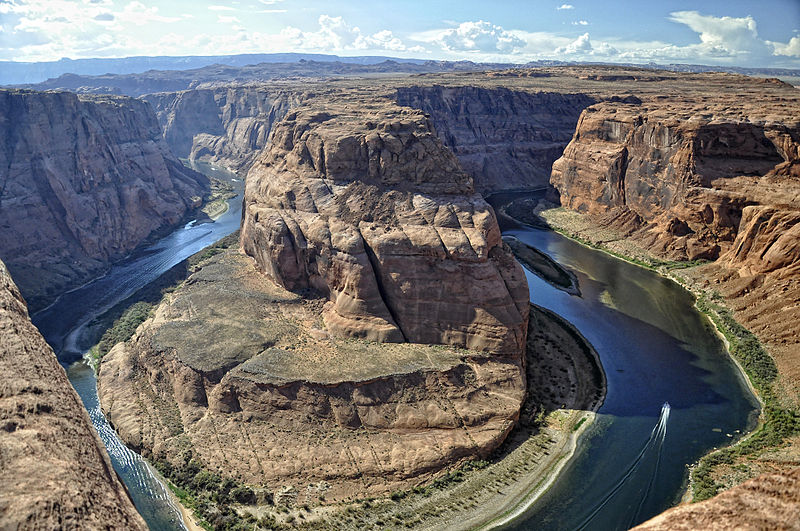
Colorado River at Horseshoe Bend P. Hermans
September 27, 2012 Wikipedia Colorado River CC BY-SA 3.0
The Lower Colorado River provides for Las Vegas, Los Angeles, San Diego, Phoenix, and Tucson.
There is already a one million acre-foot deficit, and the river is in danger of running dry far before it reaches Pacific.
Scientists have predicted that climate change will reduce the river's flow by between 10% and 30% by 2050.
The river is also under attack from construction projects, radioactive mining pollution and groundwater pumping.[1]
Western Resource Advocates have identified several steps humans need to take to save 4.4 million acre-feet of water in the Colorado River
basin while protecting the west's recreational economy, even during droughts:
improving municipal water conservation with xeriscaping and water-saving appliances, increasing municipal water recycling, improving agricultural efficiency,
utilizing more renewable wind, solar and geothermal energy, implementing water saving opportunities by removing invasive plants, reducing dust on snow that increases evaporation,
targeting desalinization of inland groundwater, and determining anticipated water demands for the next 30 years.[1]
Sources:
[1]
American Rivers. Colorado River: Colorado, Wyoming, Utah, New Mexico, Nevada, Arizona, California.
https://www.americanrivers.org/river/colorado-river/
[2]
Wescoat, J. L. & Loeffler, M. J. Colorado River. Encyclopaedia Britannica.
https://www.britannica.com/place/Colorado-River-United-States-Mexico
[3]
Norviel, W. S., McClure, W. F., Carpenter, D. E., Scrugham, J. G., Davis, Jr., S. G., Caldwell, & R. E., Emerson, F. C. (November 24, 1922). Colorado River Compact.
https://www.usbr.gov/lc/region/g1000/pdfiles/crcompct.pdf
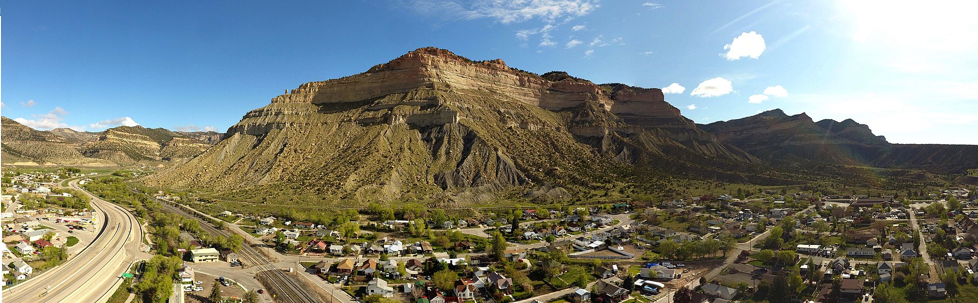
Book Cliffs
Book Cliffs, Helper, Utah C. M. Warnock May 10, 2019 Wikipedia Book Cliffs
https://en.wikipedia.org/wiki/Book_Cliffs#/ media/File:Bookcliffs.helperUT.jpg BY-SA 4.0
Part of the world's longest continuous escarpment, Book Cliffs begin in the east-central part of the state near Helper and extend into Colorado.
The cliffs got their name because in some light they appear like a book lying sideways.
The federal government administers these cliffs which are used primarily as grazing and wilderness.[1]
Powell described the beautiful colors of the cliffs:
The beds of which they are composed are shales and sandstones of many shades of blue, gray, and buff.
In the distance, and softly blended by atmospheric haze, the towering walls have an azure hue.
Everywhere they are elaborately water carved, and the bold battlements above are buttressed with sculptured hills.[2]
These Cretaceous cliffs are marine sandstones and shales.[3]
Sources:
[1]
Editors of Encyclopaedia Britannica. Book Cliffs. Encyclopaedia Britannica.
https://www.britannica.com/place/Book-Cliff
[2]
Powell, J. W. (1879). Chapter VI: The Lands of Utah.
Report on the Lands of the Arid Region of the United States with a More Detailed Account of the Lands of Utah.
https://pubs.usgs.gov/unnumbered/70039240/report.pdf
[3]
Natural History Museum of Utah. Range Creek Geography & Geology.
https://nhmu.utah.edu/range-creek-geography-geology
Roan Cliffs
The Roan Cliffs, higher and north of the Book Cliffs, are composed of river and flood plain deposits from the Paleocene and Eocene.
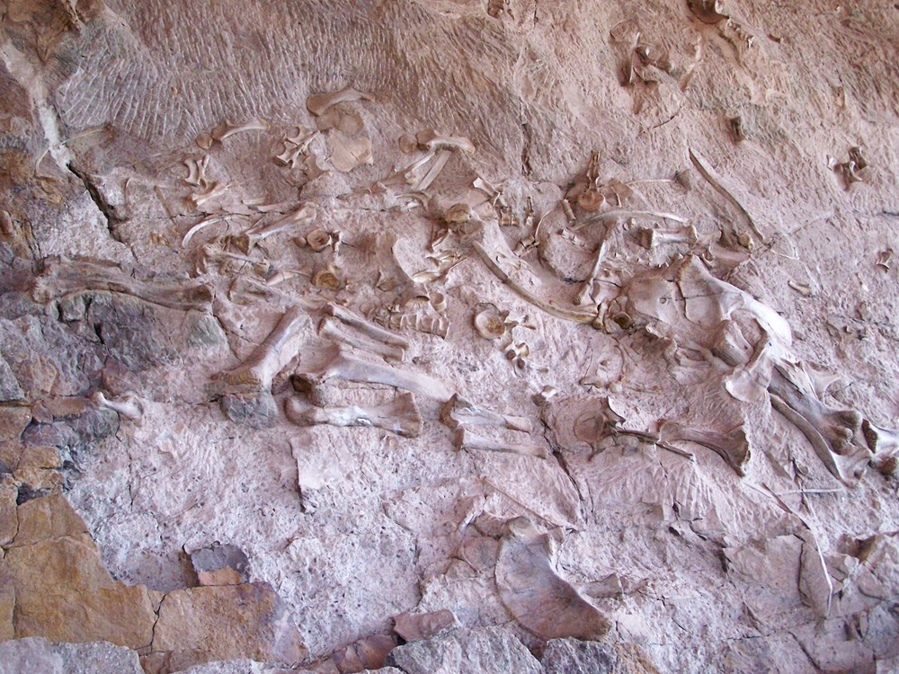
Fossilized shells and reptile bones found in the cliffs provide evidence that millions of years ago there was a large inland sea that covered the area.
[1]
Sources:
[1]
Natural History Museum of Utah. Range Creek Geography & Geology.
https://nhmu.utah.edu/range-creek-geography-geology
Green River
Green River M. Tobin January 28, 2018 Wikipedia Green River
https://commons.wikimedia.org/wiki/ File:Green_River-Utah-Aerial-Photo-2018.jpg CC BY-SA 4.0
Thompson described the meanderings of the Green River, part of which goes into Colorado.
It flowed through a small valley, Brown's Park, where a few small streams joined the river from the mountains on the north and south.
He observed extensive flood plains, many natural meadows and cottonwood groves.[1]
He noted that some of the area was "valueless badlands," but
"when the general industries of the country shall warrant the great expenditure necessary, the Green will be taken out to irrigate the bench lands on either side."[1]
Lying along the Green and between the foot of Split Mountain Canyon and the mouth of the Uinta, were 50 square miles of arable land.
Thompson determined that some of that land was subject to flooding, but most was above the high water mark.
He calculated that Green River carried enough water to irrigate far more land than was currently naturally irrigated and
that the construction cost for suitable dams and canals would be greater than on smaller streams.
He stated neither that, nor the engineering skill required, would be beyond the resources of any ordinary settlement.[1]
In September, 1877, Thompson determined that the Green could irrigate 860 square miles in the Gunnison Valley.
There was not enough arable land to use the Green River surplus, which flowed "unvexed to the sea."[1]
Sources:
[1]
Thompson, A. H. (1879). Chapter IX: Irrigable Lands of that Portion of Utah Drained by the Colorado River and Its Tributaries.
Report on the Lands of the Arid Region of the United States with a More Detailed Account of the Lands of Utah.
https://pubs.usgs.gov/unnumbered/70039240/report.pdf
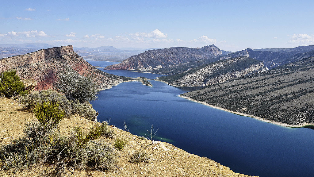
Flaming Gorge Reservoir P. Hermans September 22, 2014 Wikipedia Flaming Gorge Reservoir
https://en.wikipedia.org/wiki/Flaming_Gorge_Reservoir#/ media/File:Flaming_Gorge_(Utah)_23-9-2014_12-49-13.JPG CC BY-SA 3.0
Flaming Gorge Reservoir
Inspired by the sun's reflection off the gorge rocks, Powell named the area Flaming Gorge on May 26, 1896.
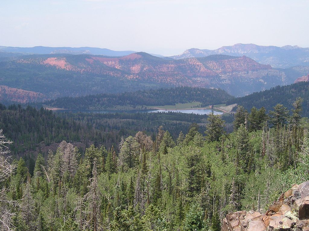
The gorge, at an elevation of 6,040 feet, is located in the Ashley National Forest, which was once the home of Comanche, Shoshoni, and Ute tribes.
[1]
The reservoir helps maintain moderate 80 degree temperatures during the summer.
It is now a popular recreation destination for boating, waterskiing, camping, parasailing, fishing, and swimming.[1]
Sources:
[1]
Utah.com. Flaming Gorge.
https://utah.com/flaming-gorge
Uinta River
This river rises in the Uinta Mountains, and runs to the south for 65 miles.
In 1869, Thompson describe the river in great detail.
It had a drainage basing of 1,300 square miles, and flowed at altitudes between 4,500 and 7,000 feet.[1]
The river, flanked by gently sloping benches, terraces, low cliffs and ridges.
Thompson found it difficult to estimate the amount of arable land, but said that the surrounding land and large meadow tracts could be easily irrigated.
He stated that because of its drainage, the river provided some of the best agricultural valleys in Utah.[1]
He noted that it had no deep canyons, and wherever the soil was fertile there were good sections of farm land.
Its highest flow was in July and lowest in October, with its critical irrigation period in August.[1]
Sources:
[1]
Thompson, A. H. (1879). Chapter IX: Irrigable Lands of that Portion of Utah Drained by the Colorado River and Its Tributaries.
Report on the Lands of the Arid Region of the United States with a More Detailed Account of the Lands of Utah.
https://pubs.usgs.gov/unnumbered/70039240/report.pdf
Duchesne River
The 80 mile Duchesne River begins in the Uintahs Wilderness Area near Mt. Agassiz, at more than 12,000 feet in altitude.
Most of the river lies in the Uintah and Ouray Reservation.[1]
The river flows south along the Wasatch and Duchesne county line, then south at Hanna through Starvation State Park near Duchesne.
From there it turns east and joins the Uintah River, not far from both the Ouray and Green Rivers.
The river then travels through Uintah County.
To the northeast on the Green River is Lodore Canyon.[1]
Sources:
[1]
McCord, M. W. (March 4, 2003). Duchesne River. Southwest Paddler.
http://southwestpaddler.com/docs/greenut7.html
Price River
The river runs easterly for about 100 miles.
It rises in the angle formed by the intersection of the Wasatch and Western Tavaputs Plateau, and gets water from the tributaries of these elevated lands.
[1]
The river crosses northern end of Castle Valley, then flows through a broken country near the foot of the Book Cliffs,
forming the southern boundary of the Tavaputs Plateau within 20 miles of the Green River.
Then it cuts through an escarpment into the plateau and joins the Green a few miles above the foot of the Gray Canyon.[1]
Thompson noted that it had about 50 square miles of arable land, most located in the Castle Valley.
He observed that this area was greater than the river's irrigation capacity, and that the soil was highly absorbant.[1]
Sources:
[1]
Thompson, A. H. (1879). Chapter IX: Irrigable Lands of that Portion of Utah Drained by the Colorado River and Its Tributaries.
Report on the Lands of the Arid Region of the United States with a More Detailed Account of the Lands of Utah.
https://pubs.usgs.gov/unnumbered/70039240/report.pdf
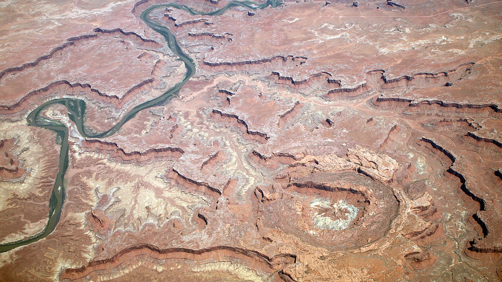
San Rafael River Gorge G. Thomas Wikipedia San Rafael River
https://en.wikipedia.org/wiki/San_Rafael_River#/ media/File:SanRafaelRiverUT2.jpg public domain
San Rafael River
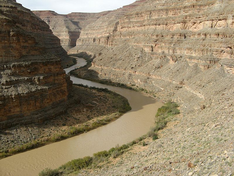
The San Rafael flows in an easterly direction, entering the Green 32 miles above the junction of that stream with the Grand.
Its three main branches are Ferron, Cottonwood and Huntington Creeks, all rising in the Wasatch Plateau at an altitude of about 10,000 feet.
These streams fall rapidly, leaving the plateau through very narrow canyons in the eastern wall overlooking Castle Valley.
They flow across the valley a few miles apart, then join together to create the San Rafael Swell.[1]
Thompson observed that the river flowed across low, broken country until it joined the Green.
He determined that the largest body of arable land within the San Rafael was in Castle Valley,
a long, narrow depression lying between the eastern escarpment of the Wasatch Plateau and San Rafael Swell.
Its southern end is drained by the tributaries of the Curtis Creek.[1]
At the time of Powell's explorations, there were no permanent settlements in the valley,
which was used as a winter herding ground for stock owned by settlers in other Utah locations.[1]
Near the branches of the San Rafael there were 200 square miles of arable land.
East of the San Rafael Swell and lying on both sides of the river at 4,000 feet, there were 20 square miles of arable land that could be easily irrigated.
Thompson reported that the river was measured in July, near the time of high water because even by July, there is still snow melting on the mountains.
Water flow could be maintained even during critical irrigation periods.
The river reached its lowest levels in October.[1]
Sources:
[1]
Thompson, A. H. (1879). Chapter IX: Irrigable Lands of that Portion of Utah Drained by the Colorado River and Its Tributaries.
Report on the Lands of the Arid Region of the United States with a More Detailed Account of the Lands of Utah.
https://pubs.usgs.gov/unnumbered/70039240/report.pdf
Dirty Devil River U.S.G.S
https://waterdata.usgs.gov/nwis/uv?09333500 public domain
Dirty Devil River
The 80 mile-long Dirty Devil River is located in southeast and central Utah.
It formed from the joining of Muddy Creek and Fremont River, 2 miles west of Hanksville.
The river then flows southeast and south through Wayne and Garfield counties to the Colorado River, 17 miles east of Mt. Hillers.[1]
A member of Powell's expedition is responsible for this river's colorful name.
As the party neared the river's mouth, one of the crew shouted, "How is she, Jack?" and Jack replied, "Oh, she's a dirty devil!"[2]
When the river was first named by the Powell and his group, they didn't distinguish how far that name would apply to this river or any of its branches.
The court system later resolved the issue.
Later, Powell changed the river's name to Fremont in honor of John Charles Fremont, cartographer and pathfinder.
The colorful name stuck, however, so Fremeont applies only to the river's upper fork.[2]
To balance the name Dirty Devil, Powell's party later named Bright Angel Creek in the Grand Canyon.[2]
Sources:
[1]
The Columbia Gazetteer of North America. (2000). Dirty Devil River. Bureau of Land Management Internet Archive Wayback Machine.
https://web.archive.org/web/20060319055556/http://www.bartleby.com/69/27/D03027.html
[2]
Van Cott, J. W. (2000). History of the Dirty Devil River in Utah. Online Utah.com.
https://onlineutah.us/dirtydevil_river.shtml
Henry Mountains S. Mahoney September 30, 2005 Wikipedia Henry Mountains
https://commons.wikimedia.org/wiki/ File:Henry_Mountains,_Utah,_2005-06-01.jpg CC BY-SA 2.5
Henry Mountains
The geology of the Henry Mountains formed over millions of years.
Erupting diorite created high domes that are now the range's five largest peaks.
The mountains have eroded, exposing the diorite, and have created arched sedimentary rocks.[1]
The Water Pocket Fold runs 909 miles on the west side of the Henry Mountains.[1]
At Lake Powell's shore the mountains are at their lowest, 3,700 feet.
At their highest at Mt. Ellen they rise to 11,600 feet.[1]
This range is the home of some spectacular geologic formations, including The Horn, near Mt. Pennell, where technical climbers test their skills.
Little Egypt, a collection of sphinx-shaped rocks, formed from Entrada sandstone, are part of this range.
Horseshoe Basin, between Bull Mountain and Mt. Ellen, displays the transition zone between the intrusive bodies and sedimentary rocks above them.
Pink Cliffs shows how igneous intrusion and uplift created nearly vertical layers of pink sandstone.[1]
In 1875 and 1876 G. K. Gilbert studied the Blue Hills south of Caineville and local stream processes.
These badlands are visible from Lost Springs and form the top of South Caineville Mesa.
Entrada sandstone spires rise from Cathedral Valley between Capitol Reef National Park and Caineville.
In some areas, black volcanic basalt pushed between sandstone and filled rock fractures rocks.[1]
One of Utah's richest uranium deposits is located in Shitamaring Canyon in this range.
The town of Ticaboo and its mill were constructed to process the uranium.[1]
More than 30% of the range's precipitation falls in July and August, during heavy thunderstorms.
The torrents sometimes melt snow, wash out roads and create rockslides that block local roads.[1]
In 1941, 18 head of bison were transplanted from Yellowstone National Park to the Henry Mountains.
Today more than 200 of them roam the lower areas in the winter and higher areas in the summer.
The bison can often be seen along the South Summit Ridge of Mt. Ellen during the warmer months.[1]
Sources:
[1]
Utah.com. Henry Mountains Utah.
https://utah.com/henry-mountains
The Chute at Muddy Creek G. Thomas May 5, 2006 Wikipedia Muddy Creek
https://en.wikipedia.org/wiki/Muddy_Creek_(central_Utah)#/ media/File:MuddyCreekChuteUT.jpg public domain
Muddy Creek
Muddy Creek starts in the hills of the Wasatch Plateau, flows across the southwest corner of the San Rafael Swell, then into the desert.
It joins the Fremont River at Hanksville where it becomes the Dirty Devil River.[1]
It has created two magnificent, narrow canyons though vertical rock.
The Chute, the narrowest part of the creek, eroded a deep, winding path through Cedar Mesa sandstone.
This is the same type of rock that forms the cliffs and buttes around Sedona, and at other locations on the Colorado Plateau.[1]
Sources:
[1]
The American Southwest. Slot Canyons: Muddy Creek.
https://www.americansouthwest.net/slot_canyons/muddy_creek/canyon.html
Fremont River
The largest branch of this river rises in the Un-ca-pa-ga Mountains.
After flowing in an easterly direction for 125 miles it enters the Colorado about 40 miles below the junction of the Grand and Green Rivers.
It is joined by Curtis Creek from the north, and smaller Tantalus Creek from the south.[1]
Its lower half flows through two deep canyons separated by Graves Valley, an area of 10 square miles of arable land, at an altitude of 4,500 feet.
Thompson observed that on the upper waters, at Rabbit Valley at 7,000 feet, there were 25 square miles of arable land.
He noted that land should be subject to late and early frosts, but the warm sandy soil and southeast valley slope prevented some damage.[1]
When Thompson was exploring, the valley was being used as a herd ground for cattle belonging to the Sevier Valley settlements.
The water volume flowing through Rabbit Valley in July 1875 was 175 cubic feet per second.[1]
Tantalus Creek drains in the northern portion of the eastern slope of the Aquarius Plateau.
It enters a close canyon at 8,000 feet, and continues in canyons until it passes through Water Pocket Fold, then flows along a desolate valley at the fold's foot when it
joins the Fremont River.
During warmer months the water in the creek is usually absorbed and evaporated before reaching its mouth.
In the valley at the foot of Water Pocket Fold Thompson noted that there were about 10 square miles of arable land.[1]
Sources:
[1]
Thompson, A. H. (1879). Chapter IX: Irrigable Lands of that Portion of Utah Drained by the Colorado River and Its Tributaries.
Report on the Lands of the Arid Region of the United States with a More Detailed Account of the Lands of Utah.
https://pubs.usgs.gov/unnumbered/70039240/report.pdf
Curtis Creek
Curtis Creek, the northern tributary of the Fremont River is formed by the union of several smaller streams that rise in the Wasatch Plateau.
Those branches flow across the Castle Valley at an altitude of 6,000 feet where there was 25 square miles of arable land.
The aggregated stream flow measured in September of 1876 was 47 cubic feet per second, with most of the water coming from melted snows on the surrounding plateaus.
Thompson estimated that during irrigation season the flow was about 94 cubic feet per second.[1]
The Curtis Creek then flows in a deep canyon near its junction with the Fremont in Graves Valley.
Both Curtis Creek and the Fremont receive additions to their volume from water in the canyons.
Thompson said that if all the water in the upper courses of these rivers was used to irrigate lands in the Castle and Rabbit Valleys,
a sufficient amount would be returned to their channels by percolation for irrigation.
With the addition of the accessions in the canyons, there would be more arable land in Graves Valley.[1]
Sources:
[1]
Thompson, A. H. (1879). Chapter IX: Irrigable Lands of that Portion of Utah Drained by the Colorado River and Its Tributaries.
Report on the Lands of the Arid Region of the United States with a More Detailed Account of the Lands of Utah.
https://pubs.usgs.gov/unnumbered/70039240/report.pdf
Escalante River Near Escalante, Utah U.S.G.S March 23, 2010 Wikipedia Escalante River
https://en.wikipedia.org/wiki/Escalante_River#/ media/File:Escalanteriver.jpg public domain
Escalante River
The Escalante River joins the Colorado north of the Paria River, rising under the wall forming the eastern face of the Aquarius Plateau.
It flows northeast, then east, and then southwest before reaching the Colorado.[1]
The river is 90 miles long.
The lower three-fourths of the river is in a narrow canyon with vertical sides from 900 to 1,200 feet high.[1]
Thompson noted that the river could fill the canyon, and that it would from side-to-side in a sand flood plain, frequently shifting its route.
He found no accessible arable land in the canyon because ts depth prevented its water from being used on the lands above.[1]
The head of the southwestern branch is located in Potato Valley, at an elevation of 5,000 feet, where there was 6 square miles of arable land.
Thompson calculated the July 1875 water flow at 90 cubic feet per second, observing that some of that area was being cultivated and producing good crops.[1]
Part of the east side of the Aquarius Plateau is drained by several creeks that join the Escalante in a deep gorge below Potato Valley
Each enters a narrow canyon where there was no arable land.
Thompson concluded that some of the water in those creeks could be used to irrigate grass lands at an altitude of about 8,000 feet,
but that the conditions for pasturage in the region were minimal.[1]
Sources:
[1]
Thompson, A. H. (1879). Chapter IX: Irrigable Lands of that Portion of Utah Drained by the Colorado River and Its Tributaries.
Report on the Lands of the Arid Region of the United States with a More Detailed Account of the Lands of Utah.
https://pubs.usgs.gov/unnumbered/70039240/report.pdf
San Juan River Near Honaker Trail Mostly Deserts October 23, 2010 Wikipedia San Juan Riverk
https://en.wikipedia.org/wiki/San_Juan_River_ (Colorado_River_tributary)#/media/ File:Lower_San_Juan_River.jpg CC BY-SA 3.0
San Juan River
The San Juan River begins on the slopes of the San Juan Mountains of southwest Colorado River.
The river flows through northwest New Mexico and southeast Utah before joining the Colorado River at Lake Powell.[1]
Thompson said that little was known about the river's arable lands or volume of water in its canyons and valleys.
He observed that all of the arable land flooded when the river overflowed, making cultivation impractical.[2]
Sources:
[1]
Bluff Uta. San Juan River.
https://bluffutah.org/san-juan-river/
[2]
Thompson, A. H. (1879). Chapter IX: Irrigable Lands of that Portion of Utah Drained by the Colorado River and Its Tributaries.
Report on the Lands of the Arid Region of the United States with a More Detailed Account of the Lands of Utah.
https://pubs.usgs.gov/unnumbered/70039240/report.pdf
Paria River
This river rises under the escarpment of the Pauns-a-gunt Plateau at about the same altitude as Kanab Creek and flows southwesterly for 100 miles.
It joins the Colorado River in Arizona.
Near its head at 6,000 feet it flows into an expanding canyon.
At 4,500 feet the canyon widens into a valley.
These are the only arable lands, about 25 square miles, in this river's drainage basin in Utah.[1]
Thompson observed high waters occurs in April or early May, when the volume is three times greater than in August.
In August 1874, the river flowed 30 cubic feet per second in the upper canyon, and about 40 feet per second in the lower valley.
He found settlements in both, with excellent soil.[1]
The critical irrigation period was in late June or early July.
The land in the lower valley was subject to flooding from heavy showers on the mesas in the upper part of the drainage basin, which overflowed the river.
These floods caused damage, swept away dams, broke through ditches and damaged growing crops.
As a result, the site first settled in this region was abandoned after three years.[1]
The lower valley experienced vast amounts of argillaceous sediment deposits.
During floods the ground became coated with an impervious soil layer, and growing crops was difficult because water could not be absorbed.
To store water from earlier in the year, Thompson proposed building reservoirs in upper canyons.[1]
Sources:
[1]
Thompson, A. H. (1879). Chapter IX: Irrigable Lands of that Portion of Utah Drained by the Colorado River and Its Tributaries.
Report on the Lands of the Arid Region of the United States with a More Detailed Account of the Lands of Utah.
https://pubs.usgs.gov/unnumbered/70039240/report.pdf
Uinta Mountains and Kings Peak H. K. Wright August 25, 2004 Wikipedia Uinta Mountains
https://en.wikipedia.org/wiki/Uinta_Mountains#/ media/File:Kings_Peak_with_Henry's_Fork_Basin.jpg CC BY-SA 3.0
Uinta Mountains
The Uinta Mountains, running eastward from the middle of the Wasatch Mountains and the Western Tavaputs[1],
have high mesas with many tall peaks from 12,000 to 14,000 feet.
These are the highest mountain peaks in Utah.[2]
The range was created by a single massive uplift 200 miles long and 40 to 50 miles wide.
They are steep, with sides that descend rapidly on both sides of the uplift.
The range consists of valleys and canyons eroded by rivers, rain and wind.[2]
There are many limestone ridges interspersed with mesas, covered with forests and grasses
In this region summers are short and winters are long.[2]
The Uinta Mountains form the northern edge of a great basin drained by the Colorado and its tributaries.
The west side of the basin is formed by high mesas that separate Colorado drainage from the drainage of the Great Salt Lake.[1]
Sources:
[1]
Thompson, A. H. (1879). Chapter IX: Irrigable Lands of that Portion of Utah Drained by the Colorado River and Its Tributaries.
Report on the Lands of the Arid Region of the United States with a More Detailed Account of the Lands of Utah.
https://pubs.usgs.gov/unnumbered/70039240/report.pdf
[2]
Powell, J. W. (1879). Chapter VI: The Lands of Utah.
Report on the Lands of the Arid Region of the United States with a More Detailed Account of the Lands of Utah.
https://pubs.usgs.gov/unnumbered/70039240/report.pdf
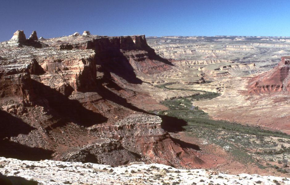
Tavaputs Plateau
The Book Cliffs border the western and southern sides of the rugged West Tavaputs Plateau, which rises to more than 10,000 feet.
The layered Cretaceous and Tertiary rock rises from the south upward from the Uinta Basin.[1]
Time has created step-like cliffs that descend to the valley below.[2]
Travel to this region is severely restricted to a few narrow, difficult trails.
Until about 1950 everything brought to this area was carried by pack animals up steep slopes.[1]
Sources:
[1]
Natural History Museum of Utah. Range Creek Geography & Geology.
https://nhmu.utah.edu/range-creek-geography-geology
[2]
United States Forest Service. Chapter 49 Ecological Subregions of the United States: Nevada-Utah Mountains Semi-Desert - Coniferous Forest - Alpine Meadow.
https://www.fs.fed.us/land/pubs/ecoregions/ch49.html#M341B
White River
The White River enters the Green River from the east, about two miles below the mouth ofthe Uinta River.
Only a small part of this river is located in Utah, but in that area there are about 75 square miles of arable land that can be irrigated.[1]
In 1877, Thompson measure the river's flow rate in October at 734 cubic feet per second.
The river's critical irrigation period was August, when it should flow at least double.
Thompson said that flow was more than sufficient to provide the needed water for irrigation.[1]
Sources:
[1]
Thompson, A. H. (1879). Chapter IX: Irrigable Lands of that Portion of Utah Drained by the Colorado River and Its Tributaries.
Report on the Lands of the Arid Region of the United States with a More Detailed Account of the Lands of Utah.
https://pubs.usgs.gov/unnumbered/70039240/report.pdf
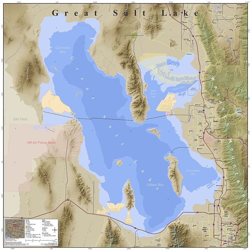
Great Salt Lake
J. Morris December 15, 2008 Wikipedia Great Salt Lake
https://en.wikipedia.org/wiki/Great_Salt_Lake#/ media/File:Great_Salt_Lake_Map.jpg CC BY-SA 3.0
Great Salt Lake
in 1874, Professor Joseph Henry of the Smithsonian Institution began a correspondence with Dr. John R. Park of Salt Lake City.
They began a systematic study of the lake's height fluctuations.
Dr. Park erected a graduated pillar at Black Rock, a popular resort on the lake's southern shore.
A local resident, Mr. John T. Mitchell read the height indicated on the pillar at frequent intervals between September 1875 and October 1876
and made two more in 1877.[1]
The beach later shifted, and the obelisk with it.
From the collected data, Park calculated that the lake rose 13 inches between 1875 and 1876 and fell 6.5 inches in 1877.[1]
The Hon. Brigham Young donated a large stone that was transported to Black Rock.
The stone was installed in a small limestone knoll, with the zero point established at 36.5 feet below the beach.[1]
A second observation station was established at a sheltered inlet at Farmington on the eastern shore.
The Farmington and Black Rock pillars were 23 miles apart.
Park determined that the Farmington zero point was approximately 16 inches lower than Black Rock zero point.[1]
A lake with an outlet has a level determined by the height of the outlet.
The height of the Great Salt Lake is determined by the relation of evaporation to inflow.
The Great Salt Lake's inflow is greatest in the spring while mountain snows are melting, and lowest in autumn before cooling has prevented evaporation in the uplands.
In late summer and the loss is greater than the gain, and the lake falls, with the maximum height in June or July, and minimum height in November.
Park calculated the difference between the two, the height of the annual tide, was about 20 inches.[1]
Annual evaporation is rarley equal to annual inflow.
Each year the lake gains or loses an amount that "depends upon the climate of the year."[1]
If the air crossing the drainage basin is moist there is a twofold tendency to raise the mean level.
Greater precipitation leads to increased inflow and less evaporation.
If the air crossing the drainage basin is dry the inflow is small.
The loss by evaporation is large, and the lake lowers.[1]
Several dry years cause the lake to drop, and several wet years cause it to rise.
Gilbert stated that this limited oscillation "depends on an oscillation of climate which is universally experienced,
but which has not been found to exhibit either periodicity, or synchrony over large areas, or other features of regularity."[1]
He noted that the lake also exhibited abnormal change attributed to the tributary streams.[1]
Sources:
[1]
Gilbert, J. K. (1879). Chapter IV: Water Supply.
Report on the Lands of the Arid Region of the United States with a More Detailed Account of the Lands of Utah.
https://pubs.usgs.gov/unnumbered/70039240/report.pdf
Wasatch Mountains and Ancient Shoreline of Lake Bonneville U.S.G.S October 23, 2010 Wikipedia Utah Lake
https://en.wikipedia.org/wiki/Utah_Lake#/media/ File:American_Fork_Canyon_and_view _of_Bonneville_terrace.jpg public domain
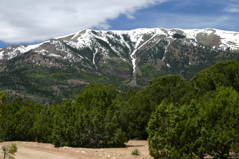
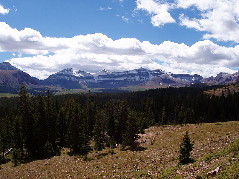
Wasatch Mountains
The Wasatch Mountains were created between 12 and 17 million years ago, when they were forced upward, creating some of Utah's most spectacular northern peaks.
They provide space for alpine lakes formed from Pleistocene glaciers.
Today the range is an important watershed and recreational area.[1]
The range begins at the Utah-Idaho border and extends into central Utah 160 miles.
Most of the range's population lives between Brigham City and Provo, a distance of about 80 miles.
Utah's capital, Salt Lake City lies at the center.[1]
They are now far more accessible than they were in 1869 when John Wesley Powell and his crew visited.
In 2002 these mountains hosted the Winter Olympics.[1]
The Wasatch Mountains contain seven U-shaped canyons that feed into the Salt Lake Valley from the range to the east.
Little Cottonwood is a 15-mile-long glacier-carved recreation area popular with climbers.
The mountains are the home to a national forest, a diverse mixture of flora and fauna and well-developed ski slopes.[1]
Big Cottonwood, a 15 mile-long canyon, is north of Little Cottonwood, is a popular climbing, skiing and cycling destination.[1]
Sources:
[1]
Utah Life Elevated. Wasatch Mountains.
https://www.visitutah.com/places-to-go/parks-outdoors/wasatch-mountains/
Bear River
The 500-mile-long Bear River, entirely enclosed by mountains, is the largest tributary of the Great Salt Lake.
The river crosses state boundaries five times, beginning and ending in Utah.
It forms a huge basin without drainage outlets.
It is the largest U.S. river on the North American continent that doesn't empty into an ocean.
[1],[2]
Gilbert described its sinuous course:
The Bear River runs northward at first, and a little beyond the foot of the mountains enters the Territory of Wyoming.
Swerving to the left, it passes again into Utah, and swerving again to the right returns to Wyoming.
From Wyoming it runs northward into Idaho, and after making a great detour to the north returns on a more westerly line to Utah.
It reenters in Cache Valley, and passes thence by a short canon to its delta plain- on the northwestern border of Great Salt Lake.[3]
Gilbert added:
For the irrigation of this amount the river is sufficient, but if the necessary water were thus appropriated, too little would remain for the use of the lands which border the contiguous
portions of the river in Wyoming. These have equal claim to the use of the river, and a proper distribution of the water would assign it to the
reclamation of the best selection of land in the two Territories.[3]
Unlike many other water sources in the U.S., today this river is harmoniously managed by three states, without adversarial water wars.[1]
Sources:
[1]
O'Donoghue, A. J. (September 30, 2017). The Bear River: A Tale of 3 States, 1 River. Deseret News.
https://www.deseret.com/2017/9/30/20620713/the-bear-river-a-tale-of-3-states-1-river#the-hydroelectric-facility-at-the-cutler-dam-and-the-bear-river-near-garland-box-elder-county-are-pictured-on-friday-sept-29-2017
[2]
Utah Department of Natural Water Resources. (2010). Great Salt Lake Information System: Bear River Watershed.
http://www.greatsaltlakeinfo.org/Background/BearRiver
[3]
Gilbert, J. K. (1879). Chapter VII: Irrigable Lands of the Salt Lake Drainage System.
Report on the Lands of the Arid Region of the United States with a More Detailed Account of the Lands of Utah.
https://pubs.usgs.gov/unnumbered/70039240/report.pdf
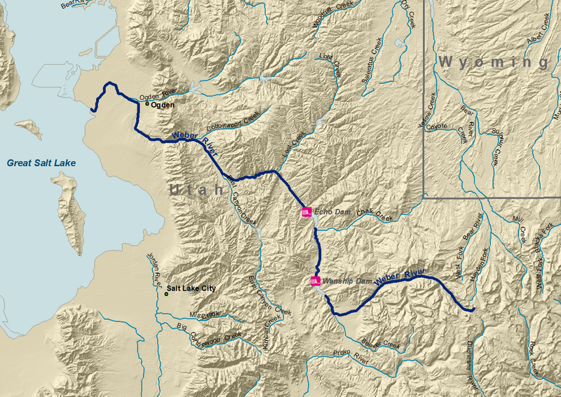
Weber River J. Morris March 25, 2006 Wikipedia Weber Rivert
https://en.wikipedia.org/wiki/Weber_River#/ media/File:Weber_River.png CC BY-SA 3.0
Weber River
The Weber River, approximately 125 miles long, begins at 11,708 feet in Summit County, near Reids Peak.
It flows west to Oakley, then turns northwesterly into the Great Salt Lake.
Its major tributaries are East Canyon Creek, Lost Creek, Chalk Creek, and Beaver Creek.[1]
The river flows into three different counties.
Half of the river is in Summit County, 25 miles is in Morgan County, and 30 miles is in Weber County.[1]
Gilbert described the river:
At the foot of the mountains it enters Kamas Prairie, in which it can be made to irrigate
a few square miles.
Thence to Hennefer, a distance of 30 miles, it is continuously bordered by a strip of farming land about one-third of a mile
broad. Then it passes a series of three close canons in the intervals of which are Round Valley, with a few acres of land, and Morgan Valley,
with 7 square miles and emerges upon its delta plain.
Within this plain are no less than 219 square miles of farming land, of which about two-fifths are now in use.[2]
Sources:
[1]
Utah Department of Natural Water Resources. (2010). Great Salt Lake Information System: Weber River Watershed.
http://www.greatsaltlakeinfo.org/Background/WeberRiver
[2]
Gilbert, J. K. (1879). Chapter VII: Irrigable Lands of the Salt Lake Drainage System.
Report on the Lands of the Arid Region of the United States with a More Detailed Account of the Lands of Utah.
https://pubs.usgs.gov/unnumbered/70039240/report.pdf
Utah Lake
Utah Lake, about 15 square miles, is the largest freshwater lake in the U.S. west of the Mississippi River, containing about 900,000 acre-feet of water.
It covers about a fourth of the Utah Valley floor.[1]
The largest tributary of Utah Lake is the Provo River, rising in the Uinta Mountains near the headwaters of the Weber and Bear Rivers.[2]
Prehistoric Lake Bonneville, which covered nearly half of Utah between between approximately 750,000 and 7250 B.C., left Lake Utah behind.
From north to south, the streams feeding into the lake are the American Fork River, Provo River, Hobble Creek, and Spanish Fork River.
The Jordan River empties out of the lake, and flows north into the Great Salt Lake.[1]
The lake and its plains were once inhabited by native Great Basin cultures from about 10,000 B.C. to A.D. 300 t0 500.
Members of the Fremont culture lived by the lake between A.D. 800 to 1600.
They grew corn, squash and beans, and used the lake and surrounding area for fishing and hunting.[1]
In A.D. 1400 there was a great drought.
The influence of the Fremont people declined, and They were replaced by three other native groups:
the Paiutes resided on the west side of the lake, the Utes on the east and the Shoshone on the north.[1]
Gilbert looked to the future of Utah Lake:
Below the reservoir the whole of the annual supply can be controlled, but above it I have assumed that irrigation will merely make use for the irrigating season of
the quantity which flows at the critical period. If artificial reservoirs can be constructed so as to store water for use in Utah Valley, a greater area can be cultivated.
With adequate storage facilities the streams tributary to the lake can irrigate in Kamas Prairie 28 miles; in Provo Valley and vicinity 40 miles;
in Thistle Valley 6 miles; on Salt Creek 16 miles, and in Utah Valley '225 miles, making a total of 315 miles ; and there will still escape to the Jordan enough
water to serve all the land assigned to that stream.[2]
Sources:
[1]
Jackson, R. H. (1994). Utah Lake. Utah History Encyclopedia.
https://www.uen.org/utah_history_encyclopedia/u/UTAH_LAKE.shtml
[2]
Gilbert, J. K. (1879). Chapter VII: Irrigable Lands of the Salt Lake Drainage System.
Report on the Lands of the Arid Region of the United States with a More Detailed Account of the Lands of Utah.
https://pubs.usgs.gov/unnumbered/70039240/report.pdf
Provo River
The Provo River is the largest tributary of Utah Lake.
The river rises in the Uinta Mountains close to the Weber and Bear Rivers, then flows in the Kamas Prairie and along the south margin of the prarie's plain.
[1]
Gilbert said that the Provo had once flowed north and joined itself to the Weber, when the prairie surface was lower,
but sand and gravel accumulated and the Provo's alluvium became so massive that the river found a new passage over the valley wall.
This new channel provided more rapid descent, quickly carving the new channel.
The sediment covered the plain, which was then abandoned.
Gilbert noted that the river then flowed in a narrow valley, 150 feet below the surface of the plain.[1]
The Kamas Prairie slopes uniformly from the Provo to the Weber, and it would be difficult to irrigate the prairie with the Weber.
Gilbert thought that the Provo could be returned to its "ancient duty with comparative ease."
He said that a canal should be built that would carry its water to the upper edge of the plain.[1]
p />
The Provo follows a rock-bound valley for 7 miles, then enters Provo Valley and then flows into Utah Valley.
Gilbert calculated that its volume was sufficient to water about 100 square miles.
He proposed that the minor streams of the American Fork, Spanish Fork, Hobble Creek and Payson Creek and the river itself could irrigate a total of 152 square miles.
Additional water mitigating efforts, including new canals, could expand the irrigation area to 225 miles.[1]
Sources:
[1]
Gilbert, J. K. (1879). Chapter VII: Irrigable Lands of the Salt Lake Drainage System.
Report on the Lands of the Arid Region of the United States with a More Detailed Account of the Lands of Utah.
https://pubs.usgs.gov/unnumbered/70039240/report.pdf
Great Basin Drainage in Utah and Nevada K. Musser November 16, 201o Wikipedia Great Basin
https://en.wikipedia.org/wiki/Great_Basin#/ media/File:Greatbasinmap.png CC BY-SA 3.0
Great Basin
The Great Basin is a 200,000 square mile drainage area, that consists of several small basins.
All precipitation in the region evaporates, sinks underground or flows into saline lakes.
There are no outlets for creeks, streams or rivers into the Pacific Ocean or the Gulf of Mexico.[1]
The region is bounded on the east by the Wasatch Mountains, on the west by the Sierra Nevada, and on the north by the Snake River Plain.
The south rim has a less distinct boundary.
The Great Basin includes most of Nevada, half of Utah and sections of Idaho, Wyoming, Oregon, and California.
The Great Salt Lake, Pyramid Lake and the Humboldt Sink serve as drains for the basins.[1]
The Basin and Range region is the product of geological forces that stretched Earth's crust.
This created a series of north-south mountain ranges separated by flat valleys and basins.[1]
The Great Basin Desert, defined by unique plant and animal communities, has a climate shaped by the rain shadows of the Sierra Nevada and Cascade Mountains.
It is hot and dry in the summer and snows in the winter.
Its valleys are dominated by sagebrush and shadescale.
Biologic communities are shaped by altitude, and individual mountain ranges act like islands with isolated vegetation.[1]
The Great Basin has a huge elevation difference between its valleys and peaks.
It supports diverse species, from those adapted to desert climates to those that live at cold, high forest altitudes.[1]
Sources:
[1]
National Park Service. (January 29, 2017). The Great Basin.
https://www.nps.gov/grba/planyourvisit/the-great-basin.htm
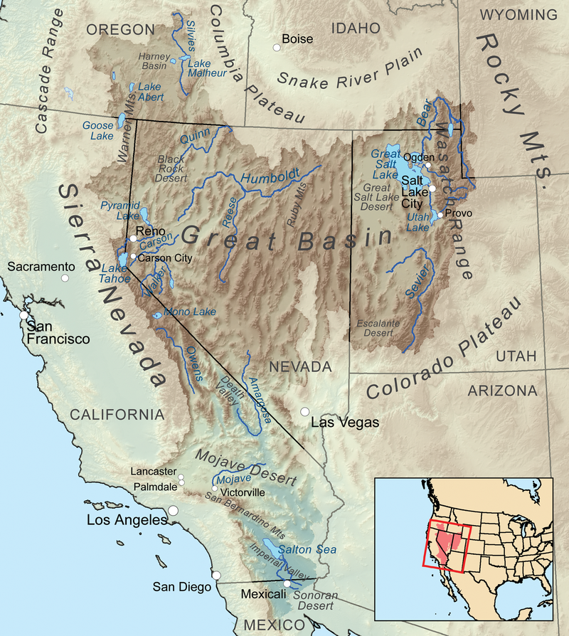
Sevier Lake Basin
This basin includes all of the land drained by waters flowing into Sevier Lake.
The arable land exceeds the irrigable land, which is already being farmed.
Powell estimated that there were 101,700 acres of irrigable land.[1]
Most of the irrigable land in this district is located along long, narrow valleys walled by plateaus along the Sevier, Otter Creek, and San Pete Rivers.
Grasses grow in the valleys and on the plateaus, where there is an abundant water supply, but little timber.[1]
Sources:
[1]
Powell, J. W. (1879). Chapter VI: The Lands of Utah.
Report on the Lands of the Arid Region of the United States with a More Detailed Account of the Lands of Utah.
https://pubs.usgs.gov/unnumbered/70039240/report.pdf
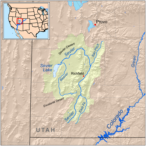
Sevier River
The river runs along the southeastern border of the Great in the west and its upper streams go into the divide separating the Colorado on the south and east
from the drainage system of the Great Basin on the north and west.
It runs in a primarily north-south direction, beginning about 270 miles nearly due south of the Great Salt Lake, and continuing north for 170 miles.
Its tributaries meander in many directions.[1]
The lower stream breaks through the Basin Ranges on the west, then dumps into Sevier Lake.
The lowest fork, called the San Pete, is located at Gunnison, 140 miles south of Salt Lake City.
That fork waters a valley about 75 miles long, which was one of the most important agricultural districts in Utah.[1]
The surrounding area consists of tabular blocks cut by faults lifted above 2,000 to nearly 6,000 feet so that absolute altitudes above sea level are 9,000 to 11,500 feet.
There are vast stretches of unbroken walls covered with precipices 10, 20, and 40 miles in length.
The the valleys are 5,000 to 7,500 feet above sea level.
Plateaus range from 400 to 1,800 square miles and with the lowlands within the drainage system have an area of about 5,400 square miles.[1]
Dutton stated that lands along the upper Sevier forks could be easily irrigated, but that they were not cultivable for grain because of short summers and danger of frosts during growth.
The amount of water carried by the Servier varied significantly during the year.
Crops would require different amounts of water, and most in July and August, when river shrinkage was at its greatest.
Dutton recommended building artificial reservoirs.
He claimed that there was no region in the world more admirably suited to easy, cheap, and efficient application of reservoir construction than in the Sevier River region.
There were also mesas with large basins broad enough for great ponds that were drained by narrow gorges cut through volcanic sheets leading to lower levels.
[1]
Sources:
[1]
Dutton, C. E. (1879). Chapter VIII: Irrigable Lands of the Valley of the Sevier River.
Report on the Lands of the Arid Region of the United States with a More Detailed Account of the Lands of Utah.
https://pubs.usgs.gov/unnumbered/70039240/report.pdf
The San Pitch and Sevier Rivers K. Musser July 29, 2008 Wikipedia San Pitch River
https://en.wikipedia.org/wiki/San_Pitch_River#/ media/File:Sevierrivermap.png CC BY-SA 3.0
San Pitch River
The San Pitch River flows north to south through the San Pete valley.
Today it is diverted along river corridors in several locations for agricultural use.
The river and its tributaries also provide recreation and a home for many fish species.[1]
The State Division of Water Quality (DWQ) has labeled the San Pitch River as a "water body of concern" based on water samples indicating excess salinity and nutrient runoff.
The river is also being subjected to wetland loss, population growth and agricultural and stormwater runoff, while in need of water and sensitive species protection.
The DWQ identified high phosphorus levels and stream erosion in the upper river, and high salinity values and stream erosion in the middle section.
High salinity negatively affect flora and fauna.[1]
The river's second major problem is unstable stream banks producing substantial sediment.
High water events cause significant stream bank erosion, dumping soil into the river.
Water quality researchers estimated that 93 tons of sediment per year enters the San Pitch.[1]
In 1983 the entire San Pitch River flooded, causing massive bank erosion. and massive
After the flood stream channel changes and erosion continued.[1]
To reduce erosion, researchers determined that it would be necessary to restore the river.
The San Pete County Soil Conservation District and the San Pitch Watershed Steward Group created a multifacited plan to reseed growth along stream banks, monitor soil, control weeds,
educate land owners, protect water, manage groundwater recharge, work with local officials and obtain funding to mitigate Twelve Mile Canyon degradation.
[1]
Sources:
[1]
Utah Department of Environmental Quality. (August 8, 2015). San Pitch River Watershed: Water Quality Management Plan.
https://deq.utah.gov/legacy/programs/water-quality/watersheds/docs/2015/08Aug/SanPitchRiver.pdf
Sevier River East and South Forks
At Circle Valley the Sevier River divides into two very nearly equal branches, the South and East Forks.
The South Fork's principal sources are on the surface of the Panguiteh Plateau, a broad expanse drained by streams.[1]
The East Fork receives waters of a valley to the east and parallel to the valley of the Sevier and separated from it by a plateau 90 miles in length, the Sevier Plateau.
The river has cut a wide gorge 4,000 feet deep and 10 miles long called the East Fork Canyon.[1]
Sources:
[1]
Dutton, C. E. (1879). Chapter VIII: Irrigable Lands of the Valley of the Sevier River.
Report on the Lands of the Arid Region of the United States with a More Detailed Account of the Lands of Utah.
https://pubs.usgs.gov/unnumbered/70039240/report.pdf
Kanab Creek
This creek rises in springs coming from underneath cliffs forming the southern boundary of the Pauns-a-gunt Plateau.
It flows southward until it joins the Colorado in Arizona.
Thompson found small areas of arable land along it after it descends to 7,500 feet, and then passes beyond Utah's boundaries.[1]
The largest connected area along the creek is the Kanab Valley at the foot of the Vermillion Cliffs, at an altitude of 5,000 feet.
It has fertile soil and requires little irrigation.
In 1877 about 700 acres were being cultivated.[1]
The creek's critical cultivation period is June, when the stream falls rapidly and water volume was estimated at 15 cubic feet per second.
Thompson said that some attempts had been made to increase the water supply by ponding the canyon above through the Vermillion Cliffs.
He believed that the amount of water available at the critical period could be doubled.[1]
A settlement was established at the foot of the Pink Cliffs on the headwater of the Kanab, but the townsite was abandoned because of deep winter snows and summer frosts.
[1]
Sources:
[1]
Thompson, A. H. (1879). Chapter IX: Irrigable Lands of that Portion of Utah Drained by the Colorado River and Its Tributaries.
Report on the Lands of the Arid Region of the United States with a More Detailed Account of the Lands of Utah.
https://pubs.usgs.gov/unnumbered/70039240/report.pdf
Virgin-Muddy River watershed in Utah, Nevada and Arizona Shannon April 2, 2010 Wikipedia Virgin River
https://en.wikipedia.org/wiki/Virgin_River#/ media/File:Virginrivermap.jpg CC BY-SA 4.0
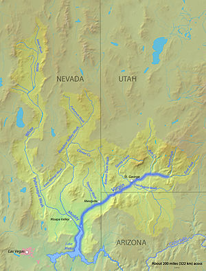
Virgin River
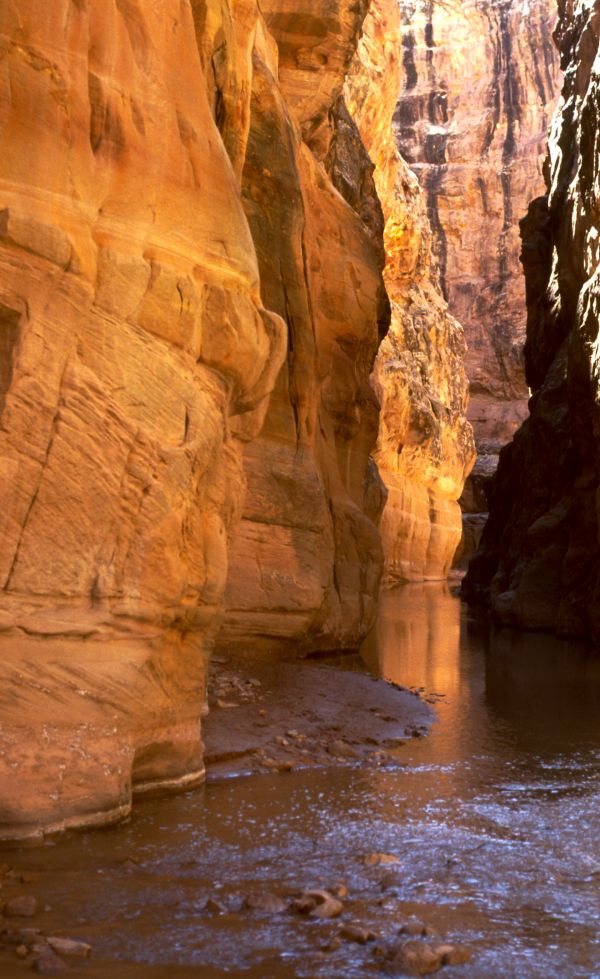
The Virgin River begins in the Colob Plateau at an altitude of about 8,000 feet.
It flows southwesterly and joins the Colorado River outside of Utah.[1]
Smaller creeks draining in the eastern portion of the plateau come together at an altitude of 5,500 feet to form the Pa-ru-nu-weap Fork of the Virgin.
The Virgin's canyon forms Long Valley, which had excellent soil.
It then enters Pa-ru-nu-weap Canyon, a series of cascades that extend for 15 miles, descending from 5,000 to 3,500 feet.
It passes through the 44 mile-long Valley of the Virgin, whose upper portion is an enlargement of the canyon, and whose lower portion is
a broader valley broken by basaltic masses and tilted sedimentary rock.[1]
The river then joins with the Little Zion, North Fork, La Verkin and Ash Creeks.
Thompson stated, with the exception of the Ash, there was little cultivable land found in these areas.
The valley of the Virgin has a lower altitude than any other part of Utah, a warmer climate and good soil that could produce abundant crops.[1]
Thompson noted that there was some difficulty when settlers began farming due to excess soil alkalinity, but over time, runoff water could remove it, allowing the land to be productive.
He also stated that ther was no reliable data concerning the amount of arable land in the drainage basin or the amount of water carried by the Virgin and its tributaries.
The Deseret Agricultural and Manufacturing Society estimated that in 1875 there was 11 square miles of irrigated land in the area.
Most of the tributary water was used, but there was a surplus of river water.[1]
Thompson stated that a portion of the Virgin River could be used below the Beaver Dam Mountains in Nevada, providing a sufficient amount to irrigate 25 square miles of land in Utah.
He calculated that the time when available water volume furnished by any stream bears the least ratio to the demands of growing crops defined the most critical perion of
soil cultivation.
During those times, artificial irrigation might be necessary.
He determined that flood height for the Virgin River occurred in April, when snow melted rapidly from the Colob Plateau.[1]
Sources:
[1]
Thompson, A. H. (1879). Chapter IX: Irrigable Lands of that Portion of Utah Drained by the Colorado River and Its Tributaries.
Report on the Lands of the Arid Region of the United States with a More Detailed Account of the Lands of Utah.
https://pubs.usgs.gov/unnumbered/70039240/report.pdf
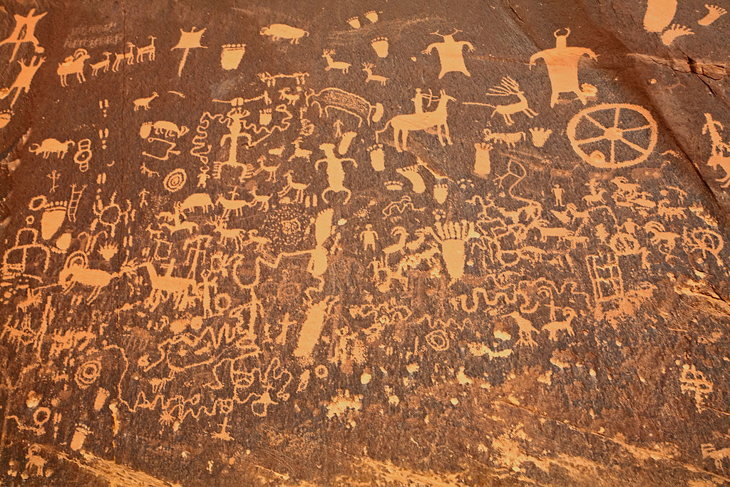
Newspaper Rock Petroglyphs Jim from Calgary May 4, 2009 Wikipedia Newspaper Rock State Historic Monument
https://en.wikipedia.org/wiki/Newspaper_Rock_State _Historic_Monument#/media/File: Newspaper_Rock_closeup.jpg CC BY-SA 2.0
National and Native American Lands
About 63% of Utah's land is owned and operated by the federal government.
These spaces include national parks, national monuments, national forests and Bureau of Land Management spaces.
Utah's national parks and five monuments are located in southern Utah.
Two monuments are in the northern part of the state.[1]
Utah has five major tribes with strong cultural legacies: Ute, Dine' (Navajo), Paiute, Goshute, and Shoshone.[2]
Rock art created by the Fremont Culture has been found on islands in the Great Salt Lake, as well as in the state's northwestern deserts.
Range Creek Canyon shelters pristine Fremont Indian rock art and ruins can also be found in Range Creek Canyon and Book Cliffs.
In 2004, the federal government purchased this area, which now has limited public visitation.
Archaeologists consider this find one of the most significant sites discovered in th last 50 years, and they are studying these sites to learn more about ancient Fremont culture.
[2]
Rock panels in Uintah County are Cockleburr Wash Petroglyphs, Little Brush Creek Petroglyphs, and the Whiterocks Village Site.
These sites are restricted from the public access to protect the petroglyphs.[3]
About 50 miles south of Moab, Newspaper Rock State Historic Monument has one of the largest petroglyph collections.
The carvings include deer, buffalo, pronghorn antelope images, horse riders and events.
These images were carefully inscribed into the dark desert varnish, manganese-iron coating that forms on sandstone cliff created by rainfall and bacteria.
The older figures are themselves becoming darker in color as new varnish slowly develops.[4]
Petroglyphs in Zion National Park were left by the Anasazi, Archaic, Basketmaker, Fremont and Piaute cultures.[5]
Sources:
[1]
Fletcher, J. USA Today.
https://traveltips.usatoday.com/national-monuments-utah-5134.html
[2]
Utah.com. Utah Native American Tribes.
https://utah.com/culture/native-american-tribes
[3]
Utah National Park Trips. (July 13, 2017). Petroglyphs in Northeast Utah.
https://www.myutahparks.com/things-to-do/petroglyphs-uintah
[4]
Utah National Park Trips. (July 13, 2017). Petroglyphs Near Moab Utah.
https://www.myutahparks.com/things-to-do/petroglyphs-moab
[5]
Utah National Park Trips. (July 10, 2017). Petroglyphs in Zion National Park.
https://www.myutahparks.com/things-to-do/zion-petroglyphs
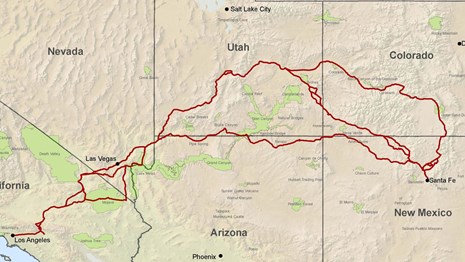
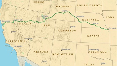
National Parks
Utah is the home national parks that are among the most beautiful, fragile, rugged, remote and historically sacred places on Earth.
One route, starting and ending in Salt Lake City, is a 7-day, 1275 mile experience to the northern Arizona border, back to central Utah,
then west, and north to Salt Lake City.[1]
You can plan your own route using the Google Map.[2]
Sources:
[1]
Utah Life Elevated. The Best Week of Your Life. Utah Office of Tourism.
https://www.visitutah.com/plan-your-trip/recommended-itineraries/the-best-week-of-your-life/
[2]
Google Maps. (February 14, 2020). Used with permission under Google Fair Use Guidelines.
https://policies.google.com/terms
Arches National Park
Arches National Park is a 73,234-acre sandstone marvel northwest of Moab.
The park has more than 2,000 natural arches, more than anywhere else in the planet.[1]
Natural bridges are formed by flowing water that cuts through sandstone.
Natural arches are formed by weathering processes but not flowing water.[2]
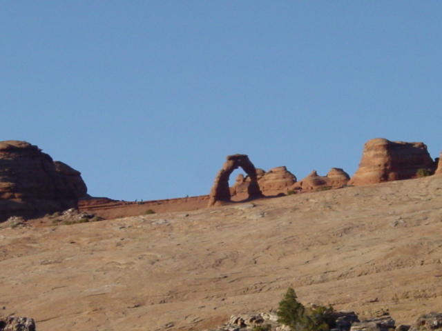
Delicate Arch in Arches National ParK D. Meeks March 14, 2006
Used with permission of the photographer
Three hundred million years ago a sea flowed into the Paradox Basin near the Colorado Plateau.
During the next million years, It left behind a salt bed thousands of feet thick that was covered by sand and rock from the Uncompahgre Uplift to the northeast of the park.
[3]
About 210 million years ago the region experienced a climatic change, and became a desert.
Navajo sandstone dominated.
About 140 million years ago Entrada sandstone, the layer in which most of today's arches can be seen, was deposited on the Navajo sandstone.
Another 5,000 feet of younger sediments were deposited on the Entrada sandstone, but most of the recent deposit has been eroded.[3]
Landscape Arch is a fragile and spectacular wonder. It spans 306 feet and the second-longest on Earth.[1]
Park elevations range from 3,960 feet at the Colorado to 5,653 feet at Elephant Butte.
Half the park is is a forest of pygmy piñon pine and juniper.
The rest is naked sandstone and short, scrubby bushes and grasses.
With only 8.5 inches of annual rainfall, extreme temperature ranges and high elevation only species that can adapt to a harsh environment life here.
[1]
Sources:
[1]
Utah Life Elevated. Arches National Park.
https://www.visitutah.com/places-to-go/parks-outdoors/arches/
[2]
Lawley, R. (January 12, 2018). Earth Science Picture of the Day: Natural Bridge Versus Natural Arch.
https://epod.usra.edu/blog/2018/01/natural-bridge-versus-natural-arch.html
[3]
GeologyPage. (May 9, 2016). Arches National Park. http://www.geologypage.com/2016/05/arches-national-park.html
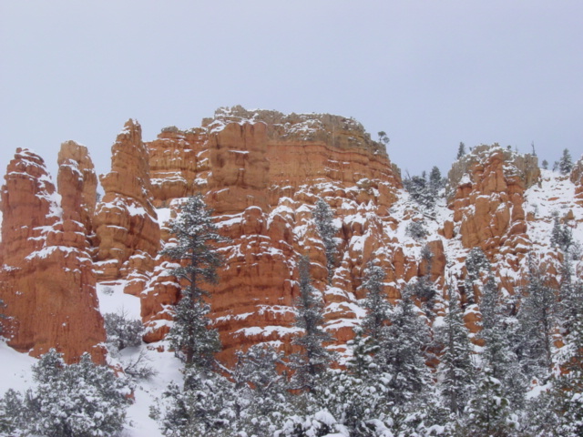
Bryce Canyon in the Winter D. Meeks March 13, 2006
Used with permission of the photographer
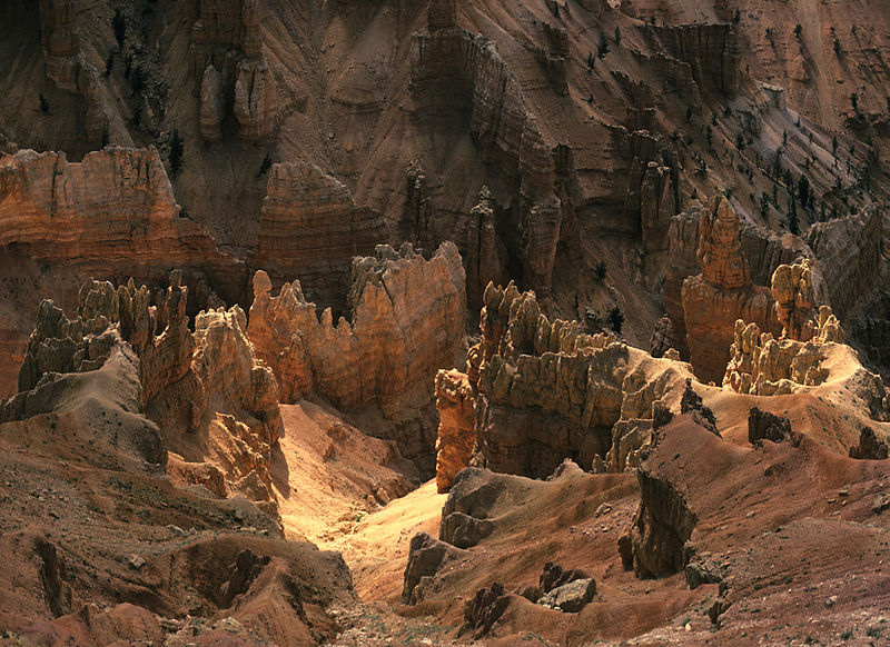
Bryce Canyon National Park
When Dutton and Powell were exploring the Colorado, the Paiutes were living in the Bryce Canyon area.
Their language provided the names of rivers and geologic features.
Paunsaugunt means home of the beavers, Paria means muddy water or elk water, Panguitch means water or fish and Yovimpa means point of pines.
[1]
Bryce Canyon is at an elevation of 8,000 to 9,000 feet.[2]
Approximately 100 inches of snow fall on the Paunsaugunt Plateau each year.[1]
This is one of the few national parks where a visitor can cross-country ski in the winter.[2]
The park's elevation is due to the uplift of the Paunsaugunt Plateau about ten million years ago.
Joints, fractures in rocks that allow them to separate, formed in the plateau during the uplift.
Water flowed in spaces between rocks, creating deep canyons.[1]
Its spectacular geology is replete with hoodoos and natural bridges.
Hoodoos are formed when rainwater seeps into rock cracks.
At night, when the temperature drops, the water freezes, expands, and fractures the rocks creating fins, which eventually erode to form holes, called windows.
When the windows grow, they fall apart, creating the mudstone hoodoos.[2]
Because mudstone is soft, it erodes easily, but new mudstone coatings replace the old during rainstorms.[1]
Limestone, siltstone, dolomite and mudstone are the four rock types of the Claron Formation.
Because each rock erodes at a different rate, hoodoos develop their unusual wavy shapes.[1]
Most spires are composed of limestone, siltstone and dolomite, which form spires' protective and more weather-resistant coverings.[1]
In 1923 President Warren G. Harding proclaimed part of the area as Bryce Canyon National Monument under what is now the Dixie National Forest.
[1]
In 2019, Bryce was designated as an International Dark Sky Park Gold Tier designation because of its exceptionally clear dark skies.[3]
Sources:
[1]
BryceCanyon.com. Bryce Canyon National Park.
https://www.brycecanyon.com/bryce-canyon-geology/
[2]
Utah Life Elevated. Bryce Canyon National Park.
https://www.visitutah.com/places-to-go/parks-outdoors/bryce-canyon/
[3]
International Dark Sky Association. Bryce Canyon National Park.
https://www.darksky.org/our-work/conservation/idsp/parks/bryce-canyon-national-park-u-s/
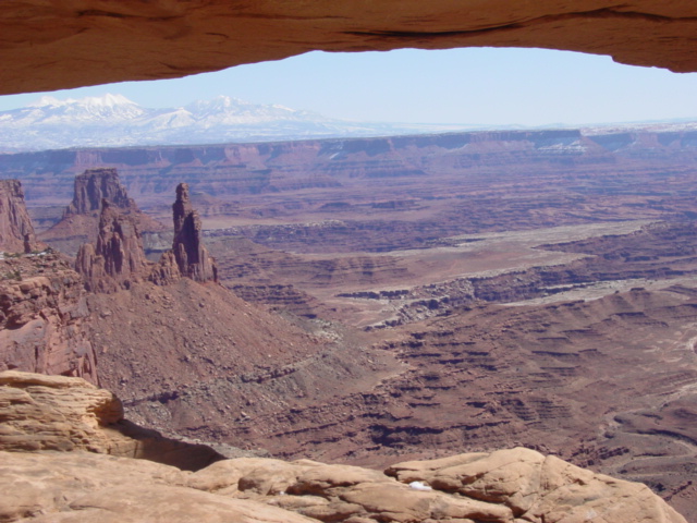
The View Through Mesa Arch in Canyonlands National Park D. Meeks March 14, 2006
Used with permission of the photographer
Canyonlands National Park
Canyonlands National Park, west of Moab, is 527 square miles of magnificent canyons, mesas, spires and cliffs formed by the Green and Colorado Rivers.
[1]
The park is divided into four districts: Island in the Sky, Needles, Maze and Horseshoe Canyon.
One of the largest and most famous features is Mesa Arch.[2]
The climate was once tropical, but it is now a desert, and home to a variety of rugged plants and animals,[3]
including mountain lions, mule deer, bobcats, cottontails and piñon pines growing in red and orange sedimentary rock.[1]
The Colorado and Green rivers wind through Canyonlands, creating deep canyons.
Below where these rivers join they flow down Cataract Canyon, creating challenging rapids.[3]
Southeast Utah was covered by oceans and rivers and mudflats and sands.
Each sedimentary layer contains information about its origins.
Red and white layers of Cedar Mesa Sandstone occur where material high in iron eroded from mountains and mixed with white sand.[3]
Like Arches National Park, Canyonlands was shaped by the events that formed the Paradox Basin.
But Canyonlands also contains a unique structure called Upheaval Dome
In an area about three miles in diameter, a serices of rock layers are deformed into a dome whose center is pushed up into a dome.
It is surrounded by a syncline, a trough of stratfied rock sloping upward.[3]
Sources:
[1]
Utah Life Elevated. Canyonlands National Park.
https://www.visitutah.com/places-to-go/parks-outdoors/canyonlands/
[2]
National Parks Traveler. (January 12, 2015). The Geology Of Canyonlands National Park.
https://www.nationalparkstraveler.org/2015/01/geology-canyonlands-national-park26119
[3]
Eisenberg, L. Canyonlands National Park. OhRanger.
http://www.ohranger.com/canyonlands/geology
Waterpocket Fold Johnleeinslc May 11, 2006 Wikipedia Waterpocket Fold
https://en.wikipedia.org/wiki/Waterpocket_Fold#/media/File:Waterpocketfold.jpg public domain
Capitol Reef National Park
Capitol Reef National Park is an 245,000 acre expanse of enormouse cliffs, huge domes and canyons.
Because of its size, it is usually quieter than Bryce and Zion Canyons.[1]
It got its name from the park's white Navajo sandstone, which evokes images of the nation's Capitol Building,
and many of its formations are shaped like ocean reefs.[2]
Nearly 10,000 feet of sedimentary strata were deposited in the area during the Permian, about 270 million years ago through the Cretaceous, 80 million years ago.
Existing formations like the red Wingate and white Navajo Sandstones form rugged cliffs.
The Chinle Formation is a soft shale that formed slopes and hills.
Slopes made of betonitic clay and shale are poor environments for plants, and remain barren.[3]
The park contains the 100-mile Waterpocket Fold, a monocline, where Earth's surface has bent.[2]
It formed between 50 and 70 million years ago when the Laramide Orogeny moved an ancient fault and started a series of mountain-building events.
Fault displacement caused the west side of the fault to move more than 7,000 feet higher than the eastern side.[3]
Capitol Reef contains scattered black boulders made of volcanic rock transported from 20 to 30 million year old lava flows from Boulder and Thousand Lake Mountains.
The boulders arrived during the Ice Age when glaciers and landslides moved these rocks from their mountain ranges.[3]
Sources:
[1]
Randall, L. (October 17, 2019). Utah's Capitol Reef National Park is like Zion Without the Crowds. Washington Post.
https://www.washingtonpost.com/lifestyle/travel/utahs-capitol-reef-national-park-is-like-zion-without-the-crowds/2019/10/16/667877a4-e930-11e9-9c6d-436a0df4f31d_story.html
[2]
Utah Life Elevated. Capitol Reef National Park.
https://www.visitutah.com/places-to-go/parks-outdoors/capitol-reef/
[3]
National Park Service. Capitol Reef.
https://www.nps.gov/care/learn/nature/geology.htm
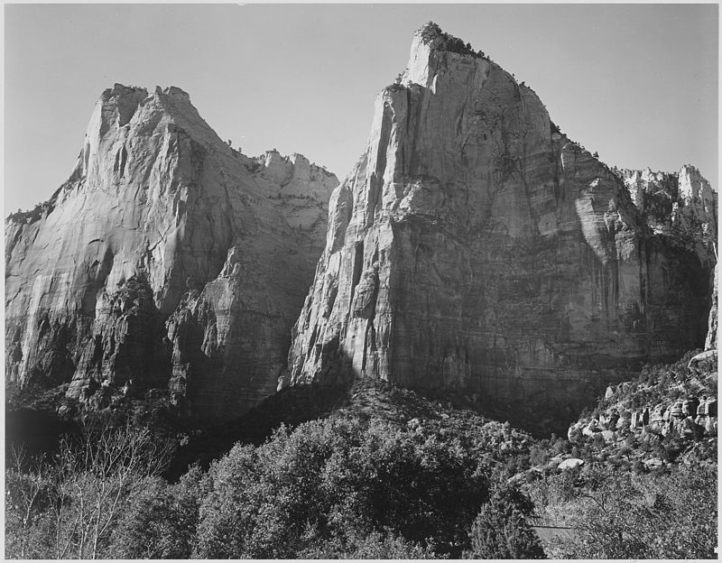
Court of the Patriarchs A. Adams
March 31, 1933 Wikipedia Zion National Park
public domain
Zion National Park
Zion is one of the most visited national parks in the United States.[1]
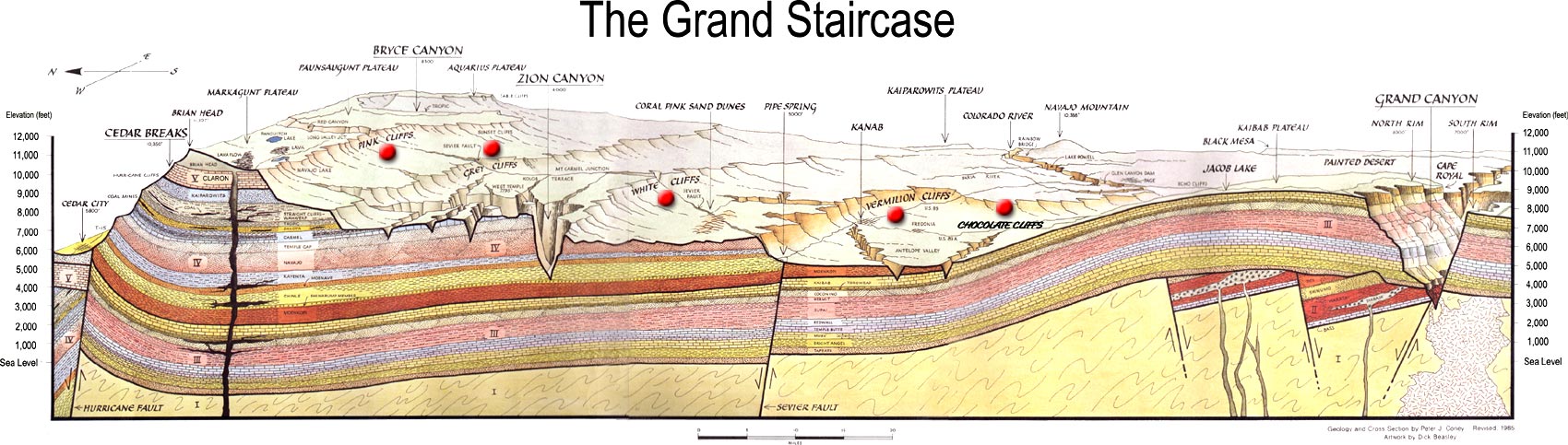
It is located at the edge of the Colorado Plateau, where the Earth has been uplifted, tilted, and weathered into the Grand Staircase,
an expanse of cliffs that stretch from the Grand Canyon to Bryce Canyon.
The bottom layer of rock at Bryce Canyon is Zion's top layer, and the top layer at Bryce is the bottom layer at Zion.[2]
About 240 million years ago Zion was nearly at sea level.
Streams deposited sand, mud and rocks carried from mountains and deposited layers that caused the basin to sink.
As more material was moved by water, the top deposits remained at sea level.
Over millions of years the land rose and fell.
As streams flowed off higher structures they cut deep erosional fissures into the existing rock.[2]
The climate changed, as seas turned into plains then into a sandstone desert, leaving more than 10,000 feet of beautiful sedimentary rock, composed of
limestone, shale, mudstone and sandstone.
Each rock has its own distinctive color.[2]
Zion's massive rocks are still being shaped by Earth.
In 1992 a 5.8 earthquake caused a landslide near Sprindale.[2]
Sources:
[1]
Utah Life Elevated. Zion National Park.
https://www.visitutah.com/places-to-go/parks-outdoors/zion/
[2]
National Park Service. Zion National Park.
https://www.nps.gov/zion/learn/nature/geology.htm
National and Native American Monuments
A U.S. national park is established by an action of Congress.
A U.S. national monument is declared by a U.S. president.
Utah contains several national monuments maintained by the National Park Service and/or by the Bureau of Land Management.
These sites are spread throughout Utah, and a wide variety of biomes, terrains and altitudes.[1]
In 1959, Monument Valley becamee a Navajo Tribal Park.
Park Headquarters and Visitors Center educate visitors about Navajo archaeology, art and crafts.
Visitors can take a self-guided scenic drive to some of the park's most famous rock formations, but others require hiring a Navajo guide.
[2]
Sources:
[1]
Guthrie, B. Utah.com. National Monuments in Utah. USA Today.
https://traveltips.usatoday.com/national-monuments-utah-5134.html
[2]
Utah.com. Utah Native American Tribes.
https://utah.com/culture/native-american-tribes
Cliff Formations at Bears Ears
United States Department of Agriculture Bears Ears National Monument
https://www.fs.usda.gov/visit/bears-ears-national-monument public domain
Bears Ears National Monument
Bears Ears, located in San Juan County in southern Utah, administered by both the Bureau of Land Management and the U.S. Forest Service,
was 1.35 million acres of sandstone canyons, mesas and forested buttes.[1],[2]
It was created by President Barack Obama in 2016.[3]
In December, 2017, the Trump administration shrank Bears Ears to 228,784 acres, just a little more than a fifth of its former size.
This action was the result of a uranium firm's lobbying, led by Andrew Wheeler, head of the Environmental Protection Agency.
Many sites sacred to Native American tribes are now unprotected outside of the significantly-reduced monument boundaries.
Trump's executive order was immediately challenged in ongoing lawsuits filed on behalf of archaeologists, conservationists and tribes.[4]
Bears Ears' name is derived from twin peaks that look like bears' ears.[2]
The Monument is made up of the Shash Jáa Unit to the south and the Indian Creek Unit to north.[1]
Bears Ears has a rich cultural heritage.
It is a sacred to several Native American tribes who use Bears Ears land for ceremonies.[2]
A lot of the land is used for livestock grazing, firewood collection, rock climbing, camping, exploration, and photography.[1]
Sources:
[1]
United States Department of the Interior Bureau of Land Management. Bears Ears National Monument.
https://www.blm.gov/node/9857
[2]
Utah.com. Bears Ears National Monument.
https://utah.com/bears-ears-national-monument
[3]
Fox, J., Tierney, L., Blanchard, S. & Gabriel Florit, G. (April 2, 2019). What Remains of Bears Ears. The Washington Post.
https://www.washingtonpost.com/graphics/2019/national/bears-ears/
[4]
Schneider, K. (December 4, 2017). In an Unprecedented Action, Trump Dramatically Shrinks Two National Monuments in Utah. Los Angeles Times.
https://www.latimes.com/nation/la-fg-trump-national-monuments-20171204-story.html
Cedar Breaks Hoodoos M. Gäbler June 30, 1988
Wikipedia Cedar Breaks National Monument.
https://en.wikipedia.org/wiki/Cedar_Breaks _National_Monument#/media/ File:Cedar_Breaks_National_Monument_partially.jpg CC BY 3.0
Cedar Breaks National Monument
Cedar Breaks is located between the Colorado Plateau and the Basin and Range province of western Utah and Nevada.
About 90 million years ago, in the late-Cretaceous period, southwestern Utah was home to a shallow sea.
Between the mountains in the west and the sea there were thousands of feet of sediment deposited by the eroding mountains.
These sediments are now the shale and brown sandstones of Straight Cliffs and Wahweap Formations of shales and brown sandstones.[1]
The sea later retreated, the Rocky Mountains rose in the east by the end of the Creataceous.
About 60 million years ago the closed basin became ancient Lake Claron, which trapped the skeletons of small ocean life in its sand and silt.
Small amounts of iron turned the sediment into red and orange layers that filled the basin.
When the climate was wet, the lake rose, and when it was dry the lake fell, leaving behind the Claron Formation, also visible in Bryce Canyon.
[1]
The Brian Head formation was created about 65 million years ago when a volcano more than 60 miles away erupted near the Utah and Nevada border.
The volcanic material preserved oysters and gastropod fossils in some of the older rocks in the Cedar Breaks amphitheater.
This rock, once under water, is now 10,000 feet above sea level.[1]
During the past 10 milliion years, earthquakes along the Hurricane Fault, located in southwestern Utah, have been lowering the land in the west, creating a valley.
The east side of the fault, moving upwards, raised Cedar Breaks and the Markagunt Plateau.
The volcanic eruptions were some of the most violent in Earth's history.
They created huge pyroclastic flows of ash, volcanic gasses and molten rock pieces, as well as tuff, visible at Leach Canyon and in the Isom Formation.
[1]
Before Markagunt Plateau uplifted, Cedar Breaks rock layers were were buried.
After exposure they were eroded, shaped by wind and water, developing joints.
Summer rains and atmospheric carbon dioxide formed a mild acid that dissolved Claron Formation limestone and enlarged the fissures between the rocks.
In the winter, water freezes in and expands the rock spaces through frost wedging.[1]
Now fins remain protected by harder rock above them, but weathering due to wind, water, erosion and gravity persist, leaving hoodoos behind.
As the fins continue to wear away they may form caves and arches.[1]
Rocks continue to fall down steep slopes, as melted snow and rains bring sediments to the valley.
Slumps, like the one at Alpine Pond, are created when landslides pile saturated rock.[1]
Sources:
[1]
National Park Service. (November 13, 2017). Cedar Breaks.
https://www.nps.gov/cebr/learn/nature/geologicformations.htm
150-Million-Year-Old Dinosaur Fossils National Park Service June 30, 1988
https://www.nps.gov/media/photo/gallery-item.htm ?pg=1826956&id=67608876-155D-451F-6711B2D2C1FCE9F2 &gid=F070B44A-155D-451F-67971A4C09C75E70 public domain
Dinosaur National Monument
Dinosaur National Monument, located on the eastern end of the Uinta Mountains, was established in 1915 to preserve paleontological discoveries of Earl Douglass and J. W. Holland.
Its rocks formed during the Laramide Orogeny about 70 to 40 million years ago.
The Canyon of Lodore, Yampa Canyon, Split Mountain Canyon, Whirlpool Canyon and Jones Hole reside in the monument.
They have been carved by the Green and Yampa Rivers.[1]
The monument has at least five caves and it is home to 14 bat species.
Its geologic units begin with Mississipian from 259 million years ago to Upper Cretaceious at 100 million years ago.[1]
Dinosaur Quarry has three layers of fossil bones.
The first layer was excavated and removed in the early 1900s.
Most of those specimens are now in museums.
The second layer of bones was uncovered and stabilized so that visitors can see them where they were found.
They comprise one of the largest Jurassic fossil discoveries with more than 1,500 specimens.
Most of the third layer has not yet been exposed.[1]
Sources:
[1]
National Park Service. (October 25, 2019). NPS Geodiversity Atlas-Dinosaur National Monument, Colorado and Utah.
https://www.nps.gov/articles/nps-geodiversity-atlas-dinosaur-national-monument-colorado-and-utah.htm
Grand Staircase-Escalante National Monument
Grand Staircase National Park Service September 8, 2005 Wikipedia Paunsaugunt Plateau
https://en.wikipedia.org/wiki/Paunsaugunt_Plateau#/media/File:Grand_Staircase-big.jpg public domain
Grand Staircase-Escalante National Monument used to cover about 1.9 million acres, but in December, 2017, the Trump administration cut it to half that size.
[1]
It consists of three distinct areas: Grand Staircase, Kaiparowits, and Escalante Canyon.
From the Kaiparowits Plateau to Escalante River Canyons, the Monument displays beautiful monoliths, slot canyons, natural bridges and arches.
This remote monument was one of the last places in the continental United States to be mapped because of its rugged landscapes.[2]
The Monument also includes five life-zones, from low-lying desert to coniferous forests.[2]
Between 950 and 1100 AD, the Anasazi and Fremont cultures lived on these lands.
They left behind rock art, home sites, campsites and granaries.[2]
Excavated fossils have provided evidence of ecosystems during an even more distant past, when dinosaurs roamed the Earth.
The Monument has proven to be an excellent research site for geologists, paleontologists, biologists, archeologists and historians.[2]
Sources:
[1]
Schneider, K. (December 4, 2017). In an Unprecedented Action, Trump Dramatically Shrinks Two National Monuments in Utah. Los Angeles Times.
https://www.latimes.com/nation/la-fg-trump-national-monuments-20171204-story.html
[2]
United States Department of the Interior Bureau of Land Management. Grand Staircase-Escalante National Monument.
https://www.blm.gov/programs/national-conservation-lands/utah/grand-staircase-escalante-national-monument
Hovenweep at Night National Park Service April 5, 2017 National Park Getaway: Hovenweep National Monument
https://www.nps.gov/articles/getaway-hove.htm public domain
Hovenweep National Monument
Petrified wood and dinosaur bone have been found at the monument.
Hovenweep includes an exposed Jurassic Morrison formation and three fossiliferous units in the Morrison, Burro Canyon, and Dakota formations.
[1]
National Park Service fossil resources are protected under the Paleontological Resources Preservation Act of 2009, Public Law 111-11, Title VI,
Subtitle D; 16 U.S.C. §§ 470aaa - 470aaa-11.[1]
This law requires that the Secretary of the Interior will create fossil management, curation processes, permit procedures, education plans and civil and criminal penalties for
illegal fossil excavation, removal, damage and sales.[2]
Hovenweep has six ancient, unique Pueblo villages that have lasted centuries because of their solid construction.
Groups built homes near canyons, where shade from cottonwood trees and cooler temperatures provided water and shade.[3]
Sources:
[1]
National Park Service. NPS Geodiversity Atlas-Hovenweep National Monument, Colorado and Utah.
https://www.nps.gov/articles/nps-geodiversity-atlas-hovenweep-national-monument-colorado-and-utah.htm
[2]
Society of Vertebrate Paleontology. (2009). Paleontological Resources Preservation Act.
http://vertpaleo.org/The-Society/Advocacy/Paleontological-Resources-Preservation-Act.aspx
[3]
Coon, S. (April 5, 20017). National Park Getaway: Hovenweep National Monument. National Park Service.
https://www.nps.gov/articles/getaway-hove.htm
Monument Valley from Ford's Point Taewangkorea March 26, 2019
Wikipedia Monument Valley
https://en.wikipedia.org/wiki/Monument_Valley#/media/File:Panoramic_view_of_Monument_Valley_from_John_Ford's_Point.jpg CC BY-SA 4.0
Monument Valley Tribal Park
At an official height of 5,564 feet above sea level, the Navajo Nation's Monument Valley Park is one of the most photographed locations on Earth.
Its Navajo name is Tse'Bii'Ndzisgaii.
It spans 91,696 acres of southern Utah and northern Arizona.[1]
This valley is the home of towers between 400 and 1,000 feet tall.
These sandstone pinnacles are surrounded by mesas and buttes, which give the valley its amazing colors, changing during the day as the sun moves across the sky.
[1]
Long before humans, the Park was a lowland basin.
For hundreds of millions of years, materials eroding from nearby mountains, built up vast sediments, cemented by pressure from the layers above.
Pressure from below uplifted the area between one and three miles above sea level
The sediment-covered basin because a spectacular plateau.[1]
Over the last 50 million years, wind and water shaped this land, exposing the harder rock and removing the softer sandstone, leaving behind Mitten Buttes and Merrick Butte.
[1]
Sources:
[1]
Navajo Nation Parks and Recreation. Monument Valley Tribal Park.
https://navajonationparks.org/tribal-parks/monument-valley/
Horse Collar Run Historical Site J. W. Frank National Park Getaway: Natural Bridges National Monument
https://www.nps.gov/articles/getaway-nabr.htm public domain
Natural Bridges National Monument
In 1908 President Theodore Roosevelt designated National Bridges National Monument the first National Park Service site in Utah.
The presidential proclamation states: "a number of natural bridges situated in southeastern Utah, having heights more lofty and spans far greater than any heretofore known to exist,
are of the greatest scientific interest."[1]
The monument provides a 9-mile loop drive past the monument's three largest stone bridges: Sipapu Bridge, Kachina Bridge, and Owachomo Bridge.
There is no other park on Earth where three large natural bridges of this size can be found so close to each other.[1]
Hundreds of years ago, as at Hovenweep, ancestral Puebloan families spent hot summers in cool wet canyons.
These ancient people left behind pictographs, petroglyphs and artifacts that have been found at Kachina Bridge.[1]
The canyons provide riparian environments with cottonwoods and coyote willows.
Canyon walls also create a great habitat for ferns, Douglas firs and other plants that thrive in canyons.[1]
In 2007, Natural Bridges National Monument was designated the world's first International Dark Sky park.
Rangers present summer night sky programs. To help share our amazing night skies, rangers present star programs many summer nights.[1]
Sources:
[1]
Coon, S. (April 2, 2018). National Park Getaway: Natural Bridges National Monument. National Park Service.
https://www.nps.gov/articles/getaway-nabr.htm
Rainbow Bridge Anthropogenic Sources Amplify
Vibration of Iconic Rainbow Bridge National Park Service https://www.nps.gov/articles/ vibration-of-rainbow-bridge.htm public domain
Rainbow Bridge National Monument
Rainbow Bridge National Monument is a part of the Colorado Plateau's Physiographic Province.[1]
Natural bridges form differently than natural arches becausee natural bridges form when a river or stream breaks through rock.
Arches are more common in the Colorado Plateau, although both are shaped by the same erosional processes.[2]
Rainbow Bridge's rocks are hundreds of millions of years old.
Its base is reddish-brown Kayenta Sandstone and mud that was deposited by an ancient inland sea more than 200 million years ago.
Above its base, the bridge is composed of Navajo Sandstone that formed about 200 million years ago when was sand dunes were deposited during a dry, desert period
that lasted several million years.
The sands and winds formed dunes more than 1,000 feet high.
Over the next 100 million years, the base and the eventual bridge rock were covered by 5,000 additional feet of other material whose weight hardened the rock below.
[2]
Colorado Plateau uplift steepened rivers, creating canyons in the plateau which were assisted by heavy rains.
The steeply flowing water easily cut through loosely-bound sandstone that dissolved like calcium carbonate bonds between the sand particles.
The Bridge Canyon stream flowed in a tight curve around a soft sandstone fin, forming a hole.
Rainbow Bridge formed when the stream changed course, running through and expanding the hole.[2]
At 290 feet high and 275 feet wide Rainbow Bridge is one of the largest natural bridges in the world.
It is a sacred site for five Native American nations: the Navajo, Hopi, San Juan, Southern Paiute, Kaibab Paiute, and White Mesa Ute.
Each year, more than 85,000 visitors from around the world come to see this spectacular formation.[3]
All rock structures vibrate in response to natural phenomena.
In Utah's monuments, the wind is the most significant source of natural vibration.
Natural bridges, arches and towers formed for millions of years in harmony with these winds.
But these delicate structures can be subjected to vibrations that amplify their natural motion.
This amplification, called resonance, can be created by earthquakes and in the last 100 years by human activity.[3]
Researchers in the University of Utah Geology & Geophysics Department are studying the effects natural events and anthropogenic activities have on these spectacular structures.
The research team set up four seismic sensors to determine what the vibrational modes were for Rainbow Bridge,
and to identify what vibrations would cause resonance in the bridge.
Two seismometers were placed on Rainbow Bridge, one was placed on a rock 25 meters away,
and one was placed on the canyon bottom, 220 meters away.[3]
How Rainbow Bridge Formed National Park Service June 5, 2015
Rainbow Bridge Geologic Formations https://www.nps.gov/rabr/learn/nature/geologicformations.htm public domain
The team discovered that Rainbow Bridge has eight vibrational modes:
vibrating up and down, side to side, and in a twisting motion, which can be seen at the video located at
Anthropogenic Sources Amplify Vibration of Iconic Rainbow Bridge.
The seismometers detected vibrations affecting the bridge caused by the waves in Lake Powell.
The team is also trying to estimate the long-term effect that helicopters, used by tour companies, have on these bridges.[3]
Rainbow Bridge and the rest of the arches, bridges and structures on the Colorado Plateau will not live forever and will be replaced by
other spectacular geologic structures carved from Utah's sandstones.[2]
Sources:
[1]
National Park Service. NPS Geodiversity Atlas-Rainbow Bridge National Monument, Utah.
https://www.nps.gov/articles/nps-geodiversity-atlas-rainbow-bridge-national-monument-utah.htm
[2]
National Park Service. (June 5, 2015). Rainbow Bridge.
https://www.nps.gov/rabr/learn/nature/geologicformations.htm
[3]
Moore, J. R., M. S. Thorne, K. D. Koper, J. R. Wood, K. Goddard, R. Burlacu, S. Doyle, E. Stanfield & B. White (2016).
Anthropogenic Sources Stimulate Resonance of a Natural Rock Bridge. Geophysical Research Letters, 43, 9669-9676. doi:10.1002/2016GL070088.
https://www.nps.gov/articles/vibration-of-rainbow-bridge.htm
Timpanogos Cave National Monument
This remote alpine cave was established as a National Monument to preserve its features of unusual scientific interest and importance.
The cave is open only about six months each year, and closed the remaining six months due to snow accumulation.
The cold winters and warm summers maintain a stable 45 degree cave temperature throughout the year.[1]
It is known for its helictites, spiral-shaped stalactites that resemble twigs.
The cave's Chimes Chamber has hundreds of six- to ten-inch long helictites, created by capillary attraction and hydrostatic pressure.
The cave also contains rare green and yellow formations, colored by nickel, included in the cave's calcite and aragonite crystals.[1]
There are many parallel cave passages along faults, which were followed by water, which carved the cave.
The Imagination Room provides an excellent demonstration of these geologic processes in action.[1]
Sources:
[1]
National Park Service. (October 17, 2018). Timpanogos Cave: Cave and Karst System.
https://www.nps.gov/tica/learn/nature/cave.htm
United States Forest Service June 12, 2011
https://en.wikipedia.org/wiki/ United_States_Forest_Service#/media/ File:Logo_of_the_United_States_Forest_Service.svg
public domain
National Forests
Most U. S. national forests are managed by the U. S. Forest Service, part of the U. S. Department of Agriculture.
They manage forests, grasslands, natural resources, trails, creeks and rivers and invasive species.[1]
The Forest Service protects, maintains and restores water, air and soil resources, but water is the most important, and the Forest Service manages the largest single source of U. S. water.
About one-fifth comes from 193 million acres of land which provides drinking water to 180 million people each day.[2]
Soil provides nutrients, water, oxygen and heat to forests.
Soils also contain delicate ecosystems.[2]
Clean air is needed by the plants, animals and humans living in and visiting forests.
The Forest Service monitors air pollution levels from wild fires, human activities at ski areas and mining that could harm tress,
streams and lakes, soils and archaeological sites.
[2]
Sources:
[1]
United States Department of Agriculture U. S. Forest Service. Managing the Land.
https://www.fs.usda.gov/#block-menu-service-footer-four-id
[2]
United States Department of Agriculture U. S. Forest Service. Water, Air, and Soil.
https://www.fs.usda.gov/science-technology/water-air-soil
Aspen in Ashley National Forest U.S. Department of Agriculture September 22, 2011
Wikipedia Ashley National Forest public domain
Ashley National Forest
The nearly 1.4 million acre Ashley National Forest is located in northeastern Utah and Wyoming.
Of the total acres, 276,175 are High Uintas Wilderness.
Forest elevations range from 6,000 feet to more than 13,500 feet at Kings Peak.[1],[2]
The forest is bordered by the Uintah and Ouray Ute Indian Reservation, Green River, Flaming Gorge National Recreatio Area, the Uinta and Wasatch-Cache National Forests,
private property, and Bureau of Land Management and State of Utah lands.
Dinosaur National Monument is about ten miles east of the forest.[1],[2]
The forest was established by President Theodore Roosevelt in 1908 to protect and manage grazing, minerals, water, timber and recreation.
Sheep, cattle, and horses are allowed to graze in the forest if their owners have permits.
The forest serves the recreational needs of more than 2.5 million visitors who engage in water and hiking activities.[2]
Sources:
[1]
United States Department of Agriculture U. S. Forest Service. Ashley National Forest.
https://www.fs.usda.gov/ashley
[2]
United States Department of Agriculture U. S. Forest Service. About the Forest.
https://www.fs.usda.gov/main/ashley/about-forest
Dixie National Forest from Yankee Meadow Overlook
March 19, 2009 https://en.wikipedia.org/wiki/ Dixie_National_Forest#/media/ File:Dixie_NF.JPG public domain
Dixie National Forest
Dixie National Forest occupies almost two million acres, 170 miles across southern Utah and sits on the divide between the Great Basin and the Colorado River.
In St. George its elevation is about 2,800 feet and at Blue Bell Knoll on Boulder Mountain it is 11,322 feet.[1]
The forest has four geographic areas and 83,000 acres of wilderness in Pine Valley, Box-Death Hollow, and Ashdown Gorge.
Boulder Mountain, one of the largest plateaus in the United States, is dotted with hundreds of small lakes 10,000 to 11,000 feet above sea level.
Some of the most rugged and remote forest terrain is even too rough for horses, while rolling hills are found at the Markagunt, Pansaugunt, and Aquarius Plateaus.
[1]
Precipitation ranges from 10 inches in the lower elevations to more than 40 inches per year near Brian Head Peak.
In higher elevations most of the precipitation falls as snow.
In July and August heavy rains make those months the wettest of the year.[1]
The forest has extreme temperatures.
St. George summer temperatures are often more than 100 degrees.
Winter temperatures at high plateaus are as low as -30 degrees.[1]
Not all of the forest is covered by trees.
There are desert plants at lower elevations, piñ pines and junipers at mid-elevations and aspen, pine, spruce and fir trees at higher elevations.
[1]
Sources:
[1]
United States Department of Agriculture U. S. Forest Service. Welcome to the Dixie National Forest.
https://www.fs.usda.gov/detailfull/dixie/home/?cid=fswdev3_006645&width=full
Fishlake National Forest
The Fishlake National Forest is located in central Utah.
Fish Lake, from which the forest gets its name, is the largest natural mountain lake in Utah.[1]
The mountains of the Fishlake provide water for neighboring communities and agricultural valleys.[2]
The forest is replete with aspens and grasses, and as a "working forest," it is managed for livestock grazing and timber management.
[1],[2]
Elk, deer, black bear, cougar moose, wild turkeys and mountain goats live in the forest.[1]
Sources:
[1]
United States Department of Agriculture U. S. Forest Service. Fishlake National Forest.
https://www.fs.usda.gov/fishlake
[2]
National Forest Foundation. Fishlake National Forest.
https://www.nationalforests.org/our-forests/find-a-forest/fishlake-national-forest
Snow in Manti-La Sal National Forest October 17, 2005 Wikipedia Manti-La Sal National Forest
https://en.wikipedia.org/wiki/Manti%E2%80%93 La_Sal_National_Forest#/ media/File:Lasalfall.jpg CC BY-SA 3.0
Manti-La Sal National Forest
The Manti-La Sal National Forest is composed of three mountain blocks in central and southeastern Utah.
The La Sal and Abajo mountain ranges provide excellent opportunities for hiking and mountain climbing.[1]
The Abajo Mountains rise 11,360 feet above sea level.
West of Monticello, Utah, roads on their red plateaus lead to Deadman Point, Babylon Pasture, and Chippean Rocks.
Exploerers can find pictographs, petroglyphs, cliff dwellings, arrowheads and pottery left by Anasazi Indains.[1]
The La Sal Mountains, where forest roads wind through mountain passes and canyons, rise to 12,721 feet above sea level.
One of these is Dark Canyon, where explorers can find crystalline rock structures.[1]
The Wasatch Plateau on the north includes Skyline Drive, a haven for bird watchers, and Arapeen Off-Highway Vehicle Trail System.
It provides access to Huntington and Eccles Canyons National Scenic Byways, at altitudes for 5,000 to 11,000 feet.
There are also foot, horse and mountain biking trails, high elevation lakes and streams and information on the discovery site of the "Huntington Mammoth."
[1]
The forest includes a power plant, coal mine, and gas exploration wells.
Forest vegetation consists of conifers, aspen and flowers that bloom in the fall.[1]
Sources:
[1]
Utah.com. Manti-La Sal Natioal Forest.
https://utah.com/manti-la-sal
Uinta-Wasatch-Cache National Forest
The Uinta-Wasatch-Cache National Forest covers parts of north-central Utah and southwestern Wyoming.
The combined forests have eight unique districts that reflect their local communities: Evanston-Mountain View, Heber-Kamas, Logan, Ogden, Pleasant Grove, Salt Lake and Spanish Fork.
Each is named for a nearby town, except the Salt Lake district, whose office is in Cottonwood Heights.[1]
The popular Tri-Canyons are located in the Salt Lake district and Kings Peak, Utah's highest mountain at 13,584 feet, in the Mountain View District.
[1]
Districts manage their own recreation facilities and activities, handle special permits, and sponsor interpretive education programs.[1]
Sources:
[1]
United States Department of Agriculture U. S. Forest Service. Uinta-Wasatch-Cache National Forest Districts.
https://www.fs.usda.gov/main/uwcnf/about-forest/districts
Recreation and Trails
Parts of three famous pioneer trails pass through Utah.
These historical routes saw thousands of settlers on their way to new lives in the west.
Lake Powell, named after the Colorado's persistent explorer, is unlike these other areas.
Nearly 150 years after those trails were established, the lake and its dam are far more modern inventions that provide water and recreation for the descendants of the settlers
who traveled west.
Glen Canyon National Recreation Area Map U.S.G.S
https://www.usgs.gov/media/images/glen-canyon-national-recreation-area-map public domain
Glen Canyon National Recreation Area and Lake Powell
Glen Canyon National Recreation Area is more than 1.25 million acres, from Lees Ferry, Arizona to the Orange Cliffs of southern Utah.
It is a geological paradise at the center of the Colorado Plateau, with fantasic vistas and ancient petroglyphs, preserving more than 10,000 years of
human interaction with and exploration of these vast lands.[1],[2]
Below Glen Canyon Dam is a deep 15 mile canyon surrounded by high walls, ancient rock art and the geology observed by Powell's expedition.
[2]
The Bureau of Reclamation began planning the Colorado River Storage Project following the 1922 Colorado River Compact.
The Bureau spent several years researching possible dam locations, and had chosen Echo Park as the dam site.
Conservationists objected because the subsequent flooding would have destroyed a national park.[3]
The conservationists won their battle, but also objected to building the dam in Glen Canyon.
Archivist Gary Topping wrote,
Glen Canyon was lost through a choice by the Sierra Club and other conservation organizations to put their efforts into saving Echo Park,
which they regarded as savable from a similar doom and to ignore (and thus sacrifice) Glen Canyon, which they thought they could not effectively defend...
The sacrifice of Glen Canyon in other words was a sin of omission by conservationists rather than a sin of commission by the Bureau of Reclamation.
[3],[4]
On April 11, 1956, the Colorado River Storage Project authorized the building of Glen Canyon Dam, which created Lake Powell, the largest human-made lake in North America.
Seven years and $300 million later, a dam 710 feet high was built.
In 1963, the Glen Canyon was closed and Lake Powell was created.
Since the building of the Glen Canyon Dam, the Sierra Club and other conservationist groups have strongly fought against the dam and have argued that Lake Powell should be drained.
[3]
Sources:
[1]
National Park Service. Lake Powell and So Much More!
https://www.nps.gov/glca/index.htm
[2]
National Park Service. Foundation Document Overview Glen Canyon National Recreation Area Rainbow Bridge National Monument.
https://www.nps.gov/glca/learn/upload/GLCA-RABR_OV_SP.pdf
[3]
Siddall, S. E. and Team. (1998). The Need for Glen Canyon Dam.
https://www2.kenyon.edu/projects/Dams/glp01smi.html
[4]
Topping, G. (1997). Glen Canyon and the San Juan Country. University of Idaho Press.
https://academic.oup.com/jah/article-abstract/85/3/1095/703840?redirectedFrom=fulltext
An American Exodus Mormon Pioneer National Historic Trail National Park Service
https://www.nps.gov/mopi/index.htm public domain
Mormon Pioneer National Historic Trail
In 1827, 21-year-old Joseph Smith claimed to have found a set of golden plates of "God's true church."
He said that an angel told him where the plates were, and had given him the ability to translate the plates into the Book of Mormon.
In 1830, in western New York, he organized the beginnings of The Church of Jesus Christ of Latter-Day Saints, whose followers are known as Mormons.
[1]
In 1838, the Mormons were driven out of Missouri and settled along a bend of the Mississippi River in Illinois.
They called their new town Nauvoo, the Hebrew word for "beautiful place."
There Smith began preaching about the Old Testament practice of polygamy.[1]
Smith gained thousands of converts, making Nauvoo Illinois' largest town.
WHen the Mormons first settled in Nauvoo, neighbors welcomed the new settlers, but disagreements soon arose.
When an opposition newspaper accused Smith and other Mormon leaders of polygamy, Smith and the Nauvoo city council ordered destruction of the paper's press.
He was then jailed in Carthage, Illinois.[1]
On June 27, 1844, Smith and his brother Hyrum were murdered in jail.
Vigilantes who opposed Mormon practices attacked Mormons, hoping that they would leave.
Brigham Young became Smith’s successor.[1]
On February 4, 1846 the first Mormon wagon trains began their trek, and stopped in Sugar Creek, Iowa to wait for Young.
On March 1, 1846, nearly 3,000 Mormons traveled across Iowa prairie, beginning their journey to Salt Lake City. toward the Missouri River.[1]
Sources:
[1]
National Park Service. Mormon Pioneer: History and Culture.
https://www.nps.gov/mopi/learn/historyculture/index.htm
Old Spanish Trail An Arduous Adventure of Rich Trade National Park Service
https://www.nps.gov/olsp/index.htm public domain
Old Spanish National Historic Trail
In 1829 Mexican trader Antonio Armijo lead the first commercial caravan from Abiquiú, New Mexico to Los Angeles.
During the next 20 years traders continued to use similar trade and exploration and horse and mule routes that became known as the Old Spanish Trail.
[1]
Santa Fe became a trading hub linking Mexico and United States markets, along with the Santa Fe Trail and El Camino Real de Tierra Adentro.[1]
Woven products from Mexico were sent from New Mexico and delivered to California, where there were few sheep.
Californians exchanged horses and mules for Mexican goods, which were then sent to New Mexico.
Mule trains traveled over the Cajon Pass, west through Rancho Cucamonga to El Monte, to Mission San Gabriel and Los Angeles.[2]
The United States government took control of the southwest in 1848 and new routes to California were created.
and use of the Old Spanish Trail sharply declined.[1]
In 2002 Congress unanimously passed an act signed by President George W. Bush that designated the trail as the Old Spanish National Historic Trail under the supervision of
the National Park Service.[2]
Sources:
[1]
National Park Service. Old Spanish: History and Culture.
https://www.nps.gov/olsp/learn/historyculture/index.htm
[2]
Masters, N. (May 26, 2011). New Mexico to Southern California: The Old Spanish Trail, Explained. KCET.
https://www.kcet.org/shows/lost-la/new-mexico-to-southern-california-the-old-spanish-trail-explained
Pony Express National Historic Trail National Park Service
https://www.nps.gov/poex/index.htm public domain
Pony Express National Historic Trail
As settlers moved west in the 1847 Mormon exodus, the 1849 Gold Rush, and on the Oregon Trail fast mail service became a necessity.
For many years cross-country mail was transported by private carriers.[1]
In 1858 postmaster general Joseph Holt limited central U.S. state and territory mail service, including to California.
William H. Russell, Alexander Majors and William B. Waddell started the Leavenworth & Pike's Peak Express Company, more commonly known as the Pony Express.
[1]
The Pony Express Trail, which operated between April 1860 and October 1861, stretched more than 1,800 miles between St. Joseph, Missouri and Sacramento, California.
It had about 190 stations and required about 10 days for several riders to cover.[2]
An ad in the Sacramento Union on March 19, 1860 looked for the adventurous to apply:
"The undersigned wishes to hire ten or a dozen men, familiar with the management of horses, as hostlers, or riders on the Overland Express Route via Salt Lake City.
Wages $50 per month and found."[1]
On June 16, 1860 Congress authorized a bill directing the Secretary of the Treasury to subsidize construction of a transcontinental telegraph line to connect
the Missouri River and the Pacific Coast.
As a result, the Overland Telegraph Company of California and the Pacific Telegraph Company of Nebraska incorporated.
During telegraph line construction the Pony Express continued mail delivery.[1]
The Pony Express ceased operating on October 26, 1861, and its last letters arrive in California in early November.
Most of the trail has disappeared, and the west the trail has been converted into dirt roads.
Clearly identifiable parts of the original trail are visible only in Utah and California.
Fifty Pony Express station ruins still exist.[1]
Sources:
[1]
National Park Service. Pony Express.
https://www.nps.gov/poex/learn/historyculture/index.htm
[2]
Wallenfelt, J. & Di Certo, J. J. Pony Express. Encyclopedia Britannica.
https://www.britannica.com/topic/Pony-Express
Denise Meeks, dmeeks@email.arizona.edu